For the last 10 days or so, most of us have been able to enjoy warm temperatures for this time of year, with many of us in the 50s and 60s. As April 1st approaches, you expect temperatures to go up. Well, unfortunately this year, temperatures will drop off significantly between this upcoming Friday, through next Tuesday. And no this is no April fools joke.
April Fools Day, this Friday, is the biggest wildcard day out of this cold snap. The GFS and Canadian models suggest temperatures will begin on the warmer side Friday Morning, in the upper 40s/low 50s for most, with 60 degrees for far Eastern PA. Then temperatures drop off as a cold front sweeps through the region, bringing with it rain showers. After the cold front passes through, everyone drops into the lower 40s by the afternoon and evening hours. If this is the case, our high temps on Friday will actually occur in the morning hours, not the afternoon.
The European Model delays the cold front until late Friday Night, so many of us actually have a rather nice Friday with temps in the upper 50s and lower 60s for Western and Central areas of PA, with temps nearing the 70 degree mark in Eastern PA. Quite the drastic difference between guidance right now.
So yes, Friday is a bit up in the air right now, however all guidance agrees that Saturday through at least Tuesday will be on the cold side.
GFS high temps for Saturday: 
Areas to the North and West, as well as higher elevations over the mountains will have high temps in the 30s, while the rest of us are sitting in the 40s.
Sunday’s temps drop off even more: 
20s for highs in Northern PA…30s for Central PA and low 40s for Southern PA. Very impressive for this time of year.
Temperatures when you head off to work and school Monday Morning will be brutal: 
Teens and twenties for low temps early Monday Morning for all of Pennsylvania…
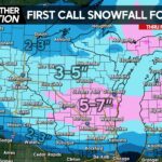
Now guidance is trending so cold, the chances for snow showers is increasing for areas in Northwest PA and the Laurel Highlands between Saturday (4/2) and Sunday (4/3). The potential is there for some of these snow showers to accumulate, especially if these snow showers occur overnight. Much of the snowfall will have a hard time accumulating on paved surfaces.
Here is the Canadian snowfall map suggesting this snowfall potential:  The afternoon’s run of the European model is not only suggesting this snowfall for these areas, but also suggests a disturbance that passes just south of PA next Tuesday (4/5), that puts PA on the wintry side of the low pressure. Verbatim delivers snow to all of PA. Can it happen? Yes, is it likely? No. For all you snow lovers out there, do not get excited over one run of the European Model. Here at PA Weather Action, we believe the snowfall is done for most locations with the exceptions of NW PA and the Laurel Highlands. Now if guidance continues to suggest the threat for snowfall next Tuesday over the next several days, we will take it a bit more serious. As for now, it is simply just eye candy for the snow lovers out there.
If you haven’t already, be sure to follow us on Facebook by simply clicking “like”. Just follow this link>>>>>>> Pennsylvania Weather Action Facebook Page!


You must be logged in to post a comment.