


A system pushing through Ohio right now, will be crossing Pennsylvania during the overnight hours and into the day on Sunday. Due to cloud coverage, Western PA will be in for a chance of showers and downpours, but nothing severe. However, skies will be more clear to the East, which will lead to increased instability and the potential for Severe Weather.
The Storm Prediction Center states the potential exists for isolated bowing-line segments capable of producing damaging winds. Tornado risk seems to be rather limited this time around, but the threat for straight-line wind damage is a concern.
Timing: Showers/downpours will arrive in Western PA in the Morning hours. For Central PA, the main threat for thunderstorms will be between 10 AM and 4 PM. Eastern PA, the main threat for thunderstorms will arrive between 4 PM and 10 PM.
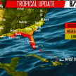
Below is the latest forecast from the Storm Prediction Center as of Saturday Afternoon.
Area A – Best chance for Severe Weather, the SPC has placed this areas under a MARGINAL RISK for Severe Weather. This is the area to watch for some of these bowing-line segments to form, which may lead to damaging winds. Straight line-winds are possible.
Area B – This area is at risk for Thunderstorms, but for the most part, the storms will remain below Severe Criteria. For Western areas in this zone, cloud coverage should prohibit storms to strengthen to severe limits and for Eastern areas in this zone, by the time these storms reach your location, sunlight will be lost leading to less instability.
For more updates “like” our page on Facebook>>>>PA Weather Action on Facebook!

[facebook_share url=”https://paweatheraction.com/bowing-line-segments-capable-of-producing-damaging-winds-possible-sunday” width=”” layout=”button_count”]
You must be logged in to post a comment.