Several days ago all models consistently indicated a snow event for the middle of this week, so what happened? A wave of energy in the Northcentral US that was originally expected to push the storm farther east into our area ended up being much weaker than expected which will allow the system to cut into the Ohio region. This will result in PA seeing primarily rain, however some front end snow will be possible Tuesday in Central and Eastern parts of Pennsylvania.
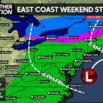
A weak low pressure system will come up the coast Tuesday, spreading rain from the Carolinas into Virginia with snow possible in Pennsylvania. We are not talking about anything significant, but likely a coating to two inches of snow in Central and Eastern PA Tuesday PM before turning to rain.
This piece of energy will actually act as a broom, sweeping the cold air straight out of our area making way for rain Wednesday. In areas outlined in white are where we expect anywhere from a coating to two inches of snow before turning over to rain Tuesday Night. There is the potential parts of Somerset and Cambria Counties see as much as four inches of snow due to higher elevation.

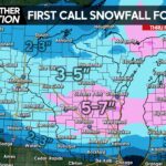
If you think this is the end of winter, you will be disappointed. Moderate to heavy lake effect snowfall will be possible in usual areas such as Erie, Meadville and Bradford from Thursday to Saturday.
Very cold air will return by the upcoming weekend which will last into Early March. We are talking daytime highs 10-15 degrees below average with nighttime lows as far as 20 degrees below average. Along with this cold, and active pattern will continue and we would not be surprised to see a few more winter storms before the season is done.
As mentioned by next weekend highs will be in the 20s and 30s with lows in the single digits and teens across the state. Also, with the Arctic Oscillation going negative and the MJO moving into the most favorable phase for cold air and winter storms in our area, winter is far from over.

We will have two more updates regarding this storm over the next several days on our Facebook Page and will go more in detail on the front end snow as it will likely occur during Tuesday’s PM Commute. Don’t forget to give us a like!>>>>>>>Pennsylvania Weather Action Facebook Page!
– Josh Adams
Share this weather update with family and friends!


You must be logged in to post a comment.