


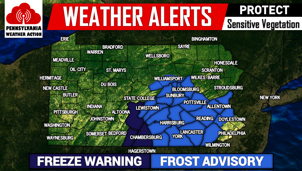
Before we talk about the nor’easter impacting our weather the second half of this weekend, tonight many areas are under Frost Advisories and Freeze Warnings. Those with gardens should protect sensitive vegetation if you wish to extend the growing season.
FROST ADVISORIES AND FREEZE WARNINGS
A strong nor’easter is expected to impact the area beginning late Saturday night and last through early Monday. A frontal passage will be passing through the area late Saturday night bringing with it moderate to heavy rainfall. This frontal passage will merge with a strong low pressure system off the coast on Sunday, leading to enhanced rainfall especially over central and eastern Pennsylvania and strong winds.
Significant differences within models still exist. Currently, the American Model (GFS), is the least aggressive with the nor’easter. However, even in this solution, the GFS produces a 979mb low pressure over Southern New England. This solution would still lead to a widespread 1 to 2 inches of rainfall and winds in the 20-30 mph range. 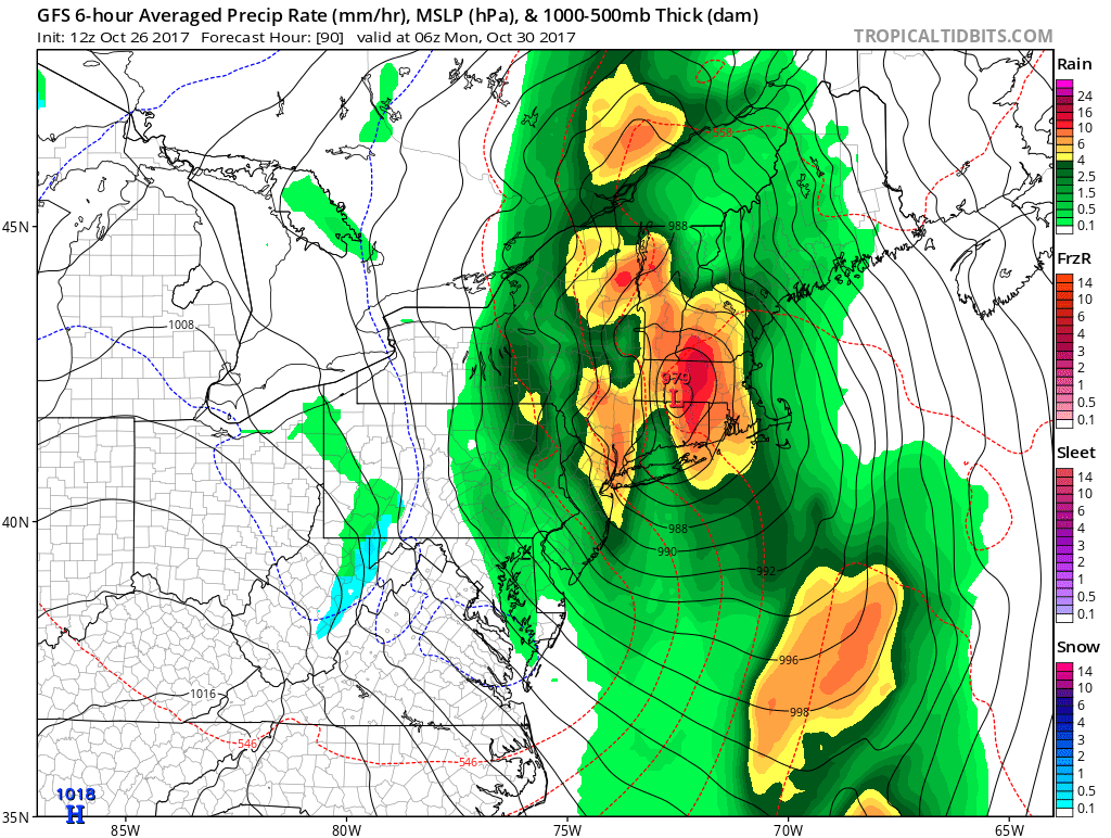
Although we cannot share the image, the most aggressive solution, the European Model, merges the front and coastal storm farther south. This leads to a stronger low pressure system and closer to the coast. In this scenario, central and eastern Pennsylvania would be hit hard with 2 to 5 inches of rainfall and winds gusting over 50 mph at times.
Western Pennsylvania would still see plenty of rainfall, in the 1 to 2 inch range. However being farther away from the low pressure, winds would be significantly weaker. The European Model is so strong, it creates enough cold air to change rain to snow for some of the higher elevations in central and eastern Pennsylvania.
We are not confident enough yet to say expect a changeover to snow for these areas, but if the European Model scenario plays out, a changeover to snowflakes for some locations is not out of the question. We are still a few days away from impact and with the current model disagreement, we expect changes.
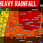
NOR’EASTER RAINFALL MAP
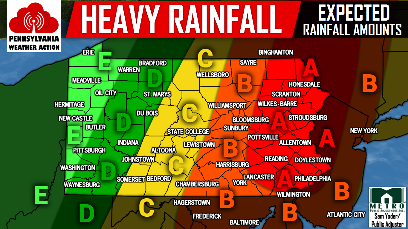
Area A – Rainfall amounts of 3-4″ are expected. Minor flooding will be possible in locations that experience prolonged heavy rain bands.
Area B – Rainfall amounts of 2-3″ are expected. Minor flooding will be possible in locations that experience prolonged heavy rain bands.
Area C – Rainfall amounts of 1-2″ are expected.
Area D – Rainfall amounts of 1″ are expected.
Area E – Rainfall amounts of .5-1″ are expected.
For a fast and easy way to track this weekend’s nor’easter and more, download our app by clicking here>>>Pennsylvania Weather Action’s App
And for those that don’t already, be sure to like our Facebook page for the latest information by clicking here>>>Pennsylvania Weather Action’s Facebook Page
Be sure to share the news of the season’s first nor’easter with your family and friends by using the button below!
You must be logged in to post a comment.