
With temperatures plunging tonight, wind chills in the teens are likely Friday Morning. Well below average temperatures will continue into the weekend with highs only in the 20s and 30s expected both Saturday and Sunday. At the same time, a low pressure system will develop in the Great Plains, moving east through the weekend. There continues to be some model disagreement. With that said, one solution appears to be emerging.
Impacts across the state will undoubted vary. However, much more of the state will get in on the winter weather action. This time, we don’t just a few hours of sleet. Some areas could see over a half foot of snow, while others will encounter much less. Snowfall amounts remain unknown at this time.
MAP FORECAST FOR WINTER STORM SUNDAY INTO MONDAY
(Category details below graphic)
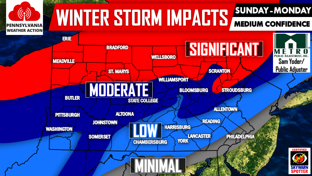
SIGNIFICANT: This area can expect mainly snowfall. Travel disruptions likely Monday Morning. Significant snowfall accumulation possible.
MODERATE: This area can expect snowfall for the majority of the storm, however the event will likely end with a few hours of rain. Travel disruptions likely Monday Morning. Moderate snowfall accumulation possible. A slight glaze of ice cannot be ruled out as upper levels warm but surface temperatures hover around freezing Late Monday Morning.
LOW: This area can expect snowfall Sunday Night, with a changeover to rain Mid Monday Morning. A slight glaze of ice cannot be ruled out with warming upper levels and ground temperatures hovering around freezing until noon Monday. Light snowfall accumulation possible. Travel disruptions possible Monday Morning.
MINIMAL: This area can expect snowfall for a few hours Sunday Night before changing over to all rain Monday Morning. Minimal snowfall accumulation possible. Slight travel is possible early Monday Morning.
We will have a First Call Forecast featuring snowfall amounts, timing, and more Friday Evening. Be sure to like us on facebook >>> PA Weather Action on facebook! Finally, don’t forget to share this forecast below with your friends and family. Stay safe!
You must be logged in to post a comment.