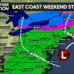
While the potential of a plowable snow Monday Night into Tuesday is growing, there is still much to be worked out especially regarding what areas will see the most snow. It all starts with a low pressure off the Carolina Coastline Sunday.
A low pressure will move northeast, likely staying far enough away from the coast, we will not have to worry about major snow. That’s the first piece of the puzzle. The second piece is how far that storm is off the coast and how strong it gets, this would affect how much energy is leftover for our main system.
Our snow will come from an Alberta Clipper, transferring its energy to a secondary low pressure south of us. Here is where the most uncertainty still lies. How far south of us will the low pressure form and in what direction will it move? Either way, if we had to select an area that most likely will get moderate snow accumulations no-matter what occurs, it would be across Southcentral PA between Somerset County to Huntingdon County to Adams County down into the Winchester, VA area.
If the secondary low pressure forms in Virginia and moves right off the coast directly east-northeast, then it’s likely East Central and Northeastern PA will receive little to no impacts from this system. However, if the low pressure forms in Virginia and moves northeast, then it’s likely nearly all of Southern PA up through East Central PA will see a moderate to even heavy snowfall.
For those interested in timing, snow will start Monday Evening across Western and Central PA, and continue through the night. The snow will actually last a fairly long duration due to the original clipper system not giving up even after it transfers most of its energy. By Tuesday Morning light snow could move into Eastern PA but the best snow looks to be back in Central PA. Heading into Tuesday Evening, snow will likely have ended in the Western Half of PA with snow still possible in Central and Eastern PA. We are confident that by Wednesday Morning snow will be done falling in all areas, with some flurries left over in the Laurel Highlands to the NW PA Mountains.

Share this weather update with family and friends!


You must be logged in to post a comment.