


It’s that time of year again! With the leaves changing and Halloween coming soon, Fall is in the air! Cooler temperatures in the air have many wondering what’s to come this upcoming winter. Will it be a repeat of last winter? Will this winter be a repeat of 2013-14 and 2014-15? Well, that’s why you’re here! It’s time for the Preliminary 2016-2017 Winter Outlook.
Featured in this outlook will be our temperature, precipitation, and snowfall predictions. But of course, we have to back-up our forecast as well. If you’re not interested in hearing he driving factors of our forecast, feel free to scroll down!
As you may have heard, the Historic El Nino we had last year that made December 2015 feel like October 2015 is gone. In fact, it’s beyond gone. We are now situated in a very weak La Nina. What does all this mean? It’s simple, sea surface temperatures in the Equatorial Pacific cooled significantly, from well above average to now slightly below average. Heading into winter, we expect to be in either a very weak La Nina or a cool Neutral ENSO phase. This of course is the most significant factor in our winter outlook.
What we believe to be the second most important factor sits in the Northeast Pacific Ocean, the Pacific Decadal Oscillation (PDO). Generally a Warm PDO translates to a Western US Ridge, thus often troughs in the East. A Cold PDO is known for influencing the pattern differently, setting a trough the west, and a ridge here in the East. For the past several winters, we have had a Positive PDO. Last year, the Strong El Nino made the PDO meaningless. However, the several snowy winters before that were likely in-part caused by a Positive PDO. This year, the PDO is not as positive as previous winters but will still play a role in the overall pattern especially due to the fact we will be experiencing a Weak La Nina or Neutral ENSO.
There are many more players in the game of a winter outlook such as the QBO, NAO, AO, MJO, EPO, and AMO. However, many of the teleconnections stated fluctuate frequently and/or do not impact the pattern as much as the ENSO and the PDO. With that said, they will definitely be monitored throughout the winter.
So what is our forecast? Let’s start with temperatures, followed by precipitation and last but not last snowfall.
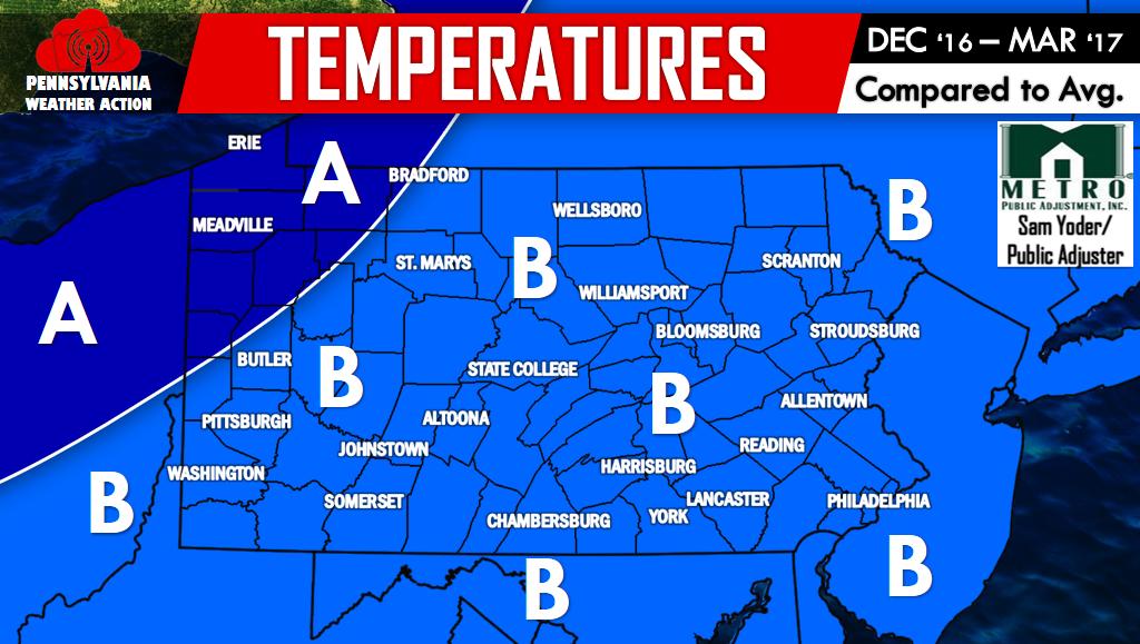
TEMPERATURES
Area A – This area is likely to experience below normal to even well below normal temperatures. Troughs frequently dropping below the area will result in relatively consistent periods of very cold temperatures. Of course there will still be times of above average temperatures, but we believe those occurrences will be limited.
Area B – This region will likely encounter below normal temperatures. However, the more harsh cold will often remain in Area A. Troughs digging south of the area will generate cold snaps often. Periods of above average temperatures will occur, but will likely be short and infrequent.
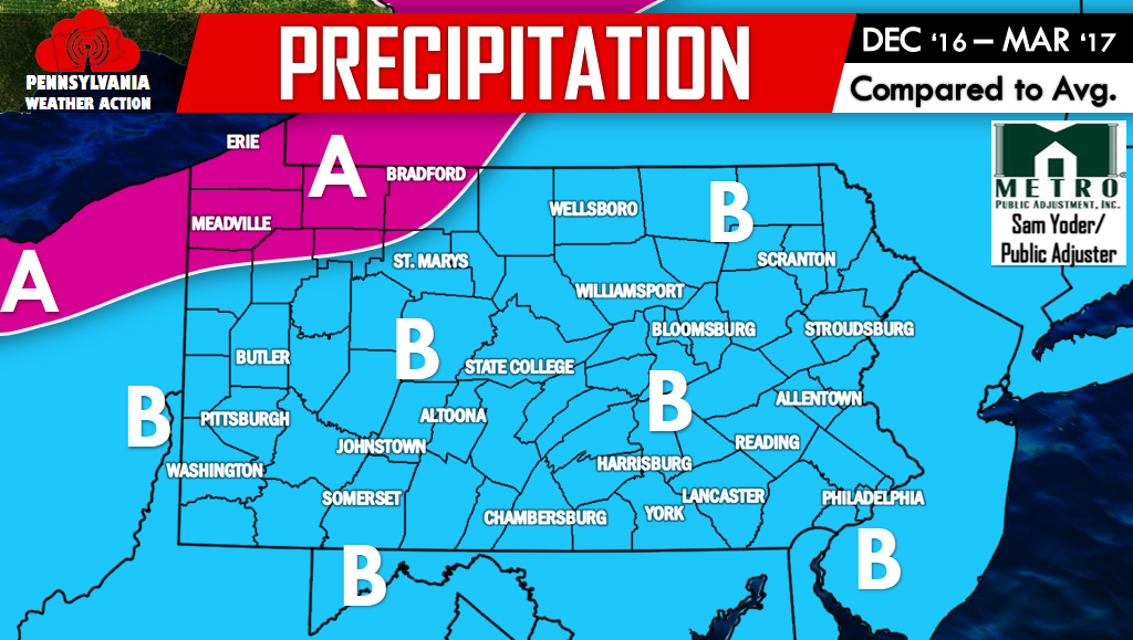
PRECIPITATION
First of all, we would like to mention that precipitation comes in different forms throughout winter, which is why this forecast is different than our snowfall forecast.
Area A – This area has a very good probability of seeing above average lake effect precipitation. Lake Erie is very warm and will take much longer than normal to completely freeze over. This means an extended lake effect season, likely lasting into a good portion of January. Other storm systems will of course impact precipitation in this area as well.
Area B – This region will likely see near normal precipitation. We do believe there will be a variety of storm systems from all different directions that move through this area.
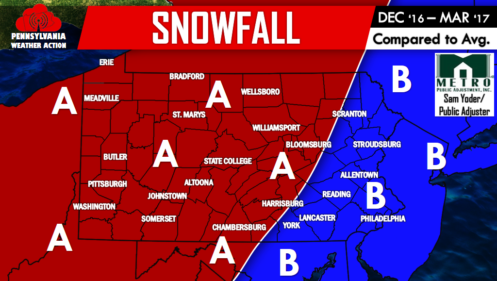
SNOWFALL
Area A – This region is likely to see above average snowfall. How far above average? We predict locations in this area will see anywhere from about 125 – 150% of their normal seasonal snowfall. For example if you average 30″, we are predicting you will see 37.5 – 45″ of snow this season. This Winter will be built on small to moderate winter storms, with a few larger storms possible. There will be many situations where the low pressure slides to the south or east, and this area will be on the cold and wintry side of the storm.
Area B – This area is likely to experience average to slightly above average snowfall. We predict locations within this area will see anywhere from 100-125% of their normal seasonal snowfall. For example if you average 20″, we are predicting you will see 20 – 25″ of snow this season. This Winter will be all about mixed events across the region. Areas on the western side of Area B have a better chance of being on the cold and more wintry side of storms rather than coastal regions.
ANNOUNCEMENT TIME!
For this upcoming winter season, on November 1st, we will be releasing a subscription called Ahead of the Action Text Alerts. This is a text alert service that will provide you with text messages for upcoming winter storms. You will be provided what to expect up to a week in advance, with daily updates regarding that particular Winter Storm and much, much more! The cost is $4.49/a month. If you sign up between November 1st and December 1st, you immediately enter yourself in a drawing to win a $50 visa gift card! The first day you will be able to sign up is November 1st, the same day we will be releasing our official Winter Forecast.
You must be logged in to post a comment.