


A winter storm that will drop all types of precipitation is expected to make a significant impact on Superbowl Sunday. An area of low pressure will begin to develop in Texas Saturday night. This low pressure will then take a track northeast, bringing with it plenty of moisture as it taps into the Gulf of Mexico moisture.
A second area of low pressure will be pushing across the Great Lakes region as the low pressure from the south is moving northeast. This is the wild card factor in this storm. How these two systems interact will determine how much snow vs rain many areas see.
We are going to use the GFS model to show a general idea of how this storm will play out. The GFS begins to develop an area of light snow over Western Pennsylvania as early as Sunday morning. The snow will then overspread much of the state by Sunday afternoon. Below is a look at 1:00 PM Sunday afternoon: 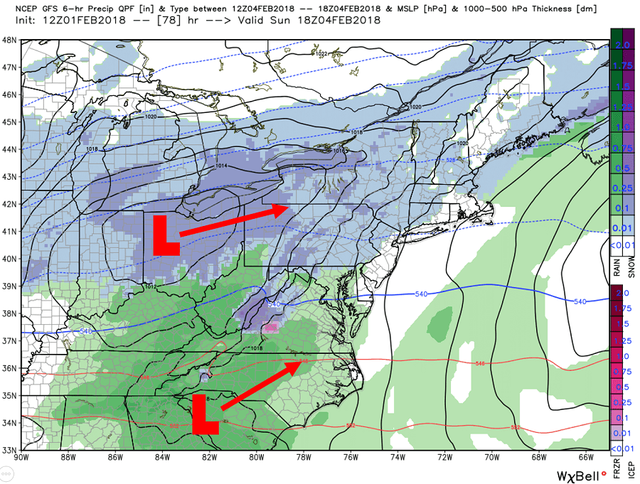
Above you can see the two low pressure systems we are referring to. Exactly how these two interact will play a big role in precipitation types. If the northern low pressure system remains the dominant low, than we have a warmer solution which will lead to a quicker transition from snow to rain in many areas. On the other hand, if the northern low were to remain weaker and merge with the southern low off the coast anywhere between Virginia and Southern New Jersey, then many of us will see a lot more snow.
Take the GFS out to 7:00 PM Sunday, the northern low remains the dominant low which allows for many of our Southern and Eastern counties to change to rain, while the interior experiences moderate to heavy snow: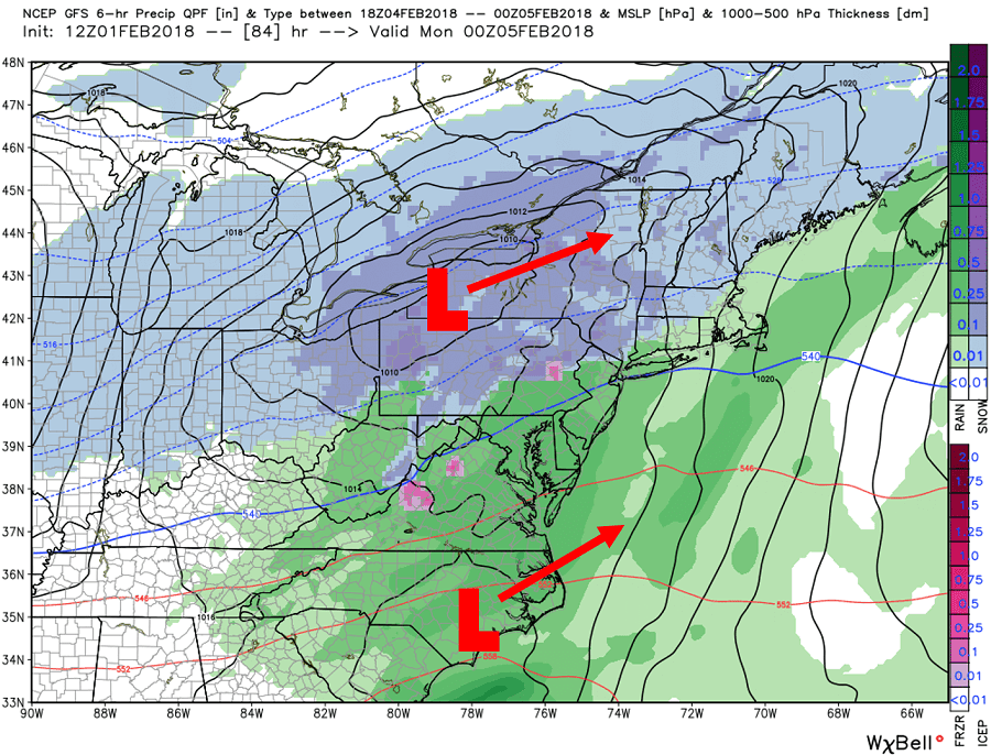
With that being said the GFS is one of multiple solutions right now as you will see with our scenarios at the end of this article. Verbatim the GFS keeps the northern low pressure stronger and separated as both low pressure systems push towards the northeast. The precipitation will likely begin to wrap up late Sunday night into early parts of Monday morning. Below is valid for 1:00 AM Monday: 
A sizable difference regarding precipitation amounts and temperatures still exists within the latest model guidance. Below is our three different scenario maps with keys below each map.
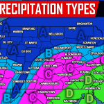
SCENARIOS FOR SUNDAY’S WINTER STORM
SCENARIO 1 – CONFIDENCE 50%:
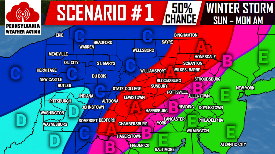
Area A – Snow to start, then mixing with freezing rain and sleet especially in the southern end of this area.
Area B – Snow at the onset, followed by a changeover sleet and then rain.
Area C – Snow for the majority of the storm, possibly mixing with sleet and ending as rain in locations south of i-80 in this area.
Area D – Snow for a few hours, then changing over to plain rain.
Area E – Light snow, then quickly changing over to rain.
SCENARIO 2 – CONFIDENCE 25%:

Area A – Snow for the majority of the storm, possibly mixing with sleet on the southern edge of this area.
Area B – Snow at the onset, followed by sleet and then rain.
Area C – Light snow at the start north of Philadelphia, then plain rain.
SCENARIO 3 – CONFIDENCE 25%:

Area A – Snow for the majority of the storm, possibly mixing with sleet and freezing rain south of State College.
Area B – Snow at the onset, followed by sleet and freezing rain with a period of plain rain at the end.
Area C – Light snow to start north of Philadelphia, then sleet quickly changing to rain.
To stay ahead of this winter storm, be sure to have us liked on Facebook by clicking here>>>Pennsylvania Weather Action’s Facebook Page.
Also, download our app here for interactive radar and the latest forecast and updates >>> PA Weather App
Be sure to share this update regarding the Superbowl Sunday winter storm with your family and friends by using our icon below!
You must be logged in to post a comment.