


OUR FIRST CALL SNOWFALL FORECAST HAS BEEN RELEASED >>> CLICK HERE TO VIEW
On March 14th, 1993, one of the largest winter storms ever recorded decimated much of the Mid-Atlantic and Northeast. Now, 24 years later, a major storm will likely impact many of the same areas late Monday Night into Tuesday.
We are now confident enough to say a storm is likely to hit the area Monday Night into Tuesday. At this point, it simply comes down to the track this storm will take. An area of low pressure will be dropping out of the Midwest and dig just north of the Tennessee Valley Monday Night. From there, alongside this low pressure system, a coastal low looks to form over the Carolina Coastline. These two systems are projected to phase and create a massive storm system Tuesday.
Where these two systems phase, is the big question. The quicker they phase together, the bigger the impact for the state of PA. The slower the phase, the less of an impact.
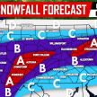
The latest GFS is indicating a quicker phase leading to a widespread major snowstorm, this radar image is valid 8 AM Tuesday: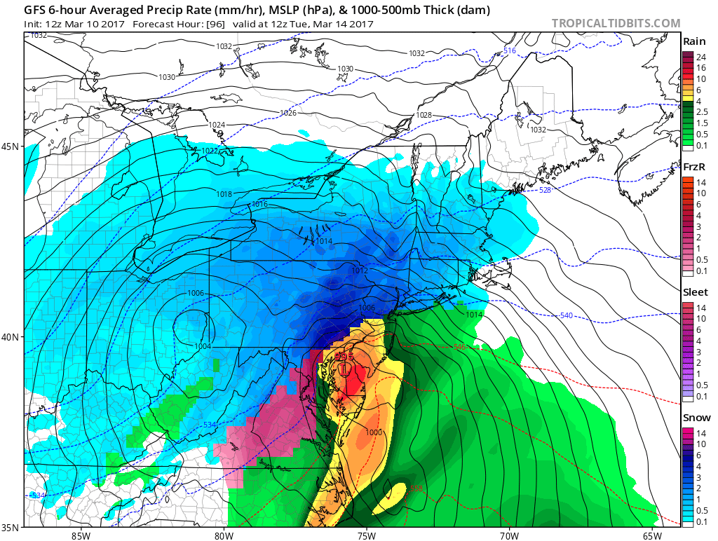
The GFS tracks the low pressure so far west, areas along the I-95 corridor mix and even change to rainfall, while the farther interior locations remain all snow. The GFS is the farthest west solution.
On the other hand, there is still a slim chance that we receive a glancing blow from this storm rather than a major hit. The Canadian model is the only model to indicate this, and odds right now are against it. The Canadian keeps the storm well east, sparing most the region from a major snowfall. We cannot stress enough that we firmly believe this solution will not occur.
The European model, statistically the most accurate model, is much more like the GFS, but colder. Although we cannot share the images publicly, we can tell you that it prints out a major snowstorm for Central and Eastern PA.
This upcoming winter storm has the chance to put down numbers some locations have not witnessed in the month of March. So needless to say, you might want to start looking for your yard stick.
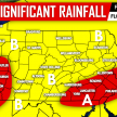
FIRST LOOK SCENARIO MAPS FOR MONDAY NIGHT INTO TUESDAY’S WINTER STORM
Timing: We will narrow the time as we get closer, but right now it looks like late Monday Night (after 8 PM) through all day Tuesday. Map keys are below each map.
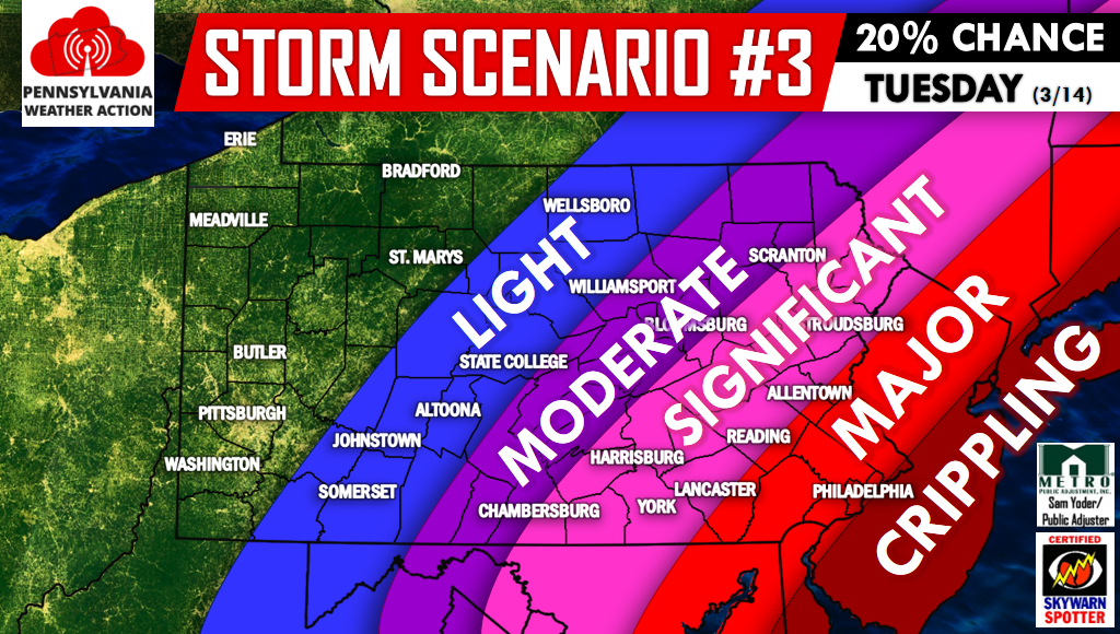
Above is Scenario #3, the least likely scenario. We are giving it a 20% chance due to the fact very little model guidance predicts this type of solution. As you can see, areas mainly across Southeast PA would see significant to major impacts. The rest of the state would be spared from the worst of the storm.
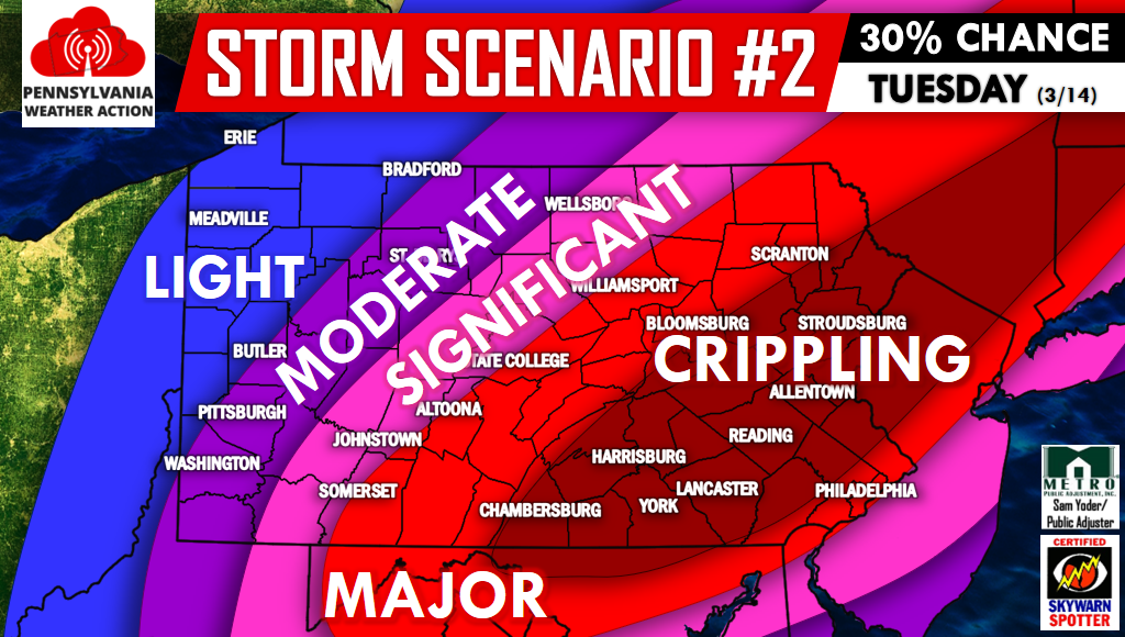
Above is Scenario #2. With this scenario, we would need early phasing to take place and the low pressure to hug the coastline. Much of the state would see major to crippling impacts if this played out.
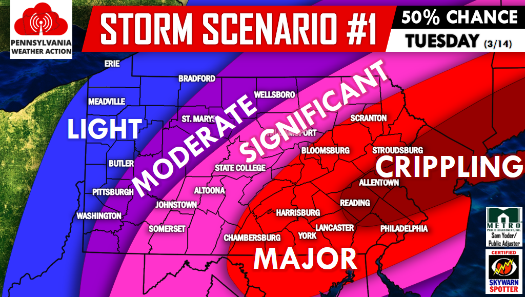
Above is Scenario #1, our most likely scenario. Much of the state will likely either experience significant, major, or crippling snowfall amounts with this storm. Travel could very well be impossible from Southcentral PA all the way up into Northeast PA.
Follow us on our Facebook page for many more updates on this potentially crippling winter storm by clicking here>>>PA Weather Action on Facebook!
Remember to warn your friends and family of this winter storm, as roads will likely be impassible for much of the day Tuesday in a good portion of the state. Our First Call is at 5 PM Saturday, stay tuned!
You must be logged in to post a comment.