
We have good news and we have bad news. The good news is, guidance has dropped snow totals somewhat for nearly the entire state. The bad news is, it now looks like there will be more ice involved especially for Central PA.
Timing: Snow will overspread the state after 8 PM Friday Evening for Western areas, and then after 11 PM for Central and Eastern areas.
As we head into the overnight hours early Saturday Morning, likely after 4 AM for Southwest PA and after 8 AM for areas further to the North and East, a changeover to sleet and freezing rain will occur. This period of sleet and freezing rain will likely last through lunchtime for Central PA and will changeover quicker to rain for areas West of the mountains, likely by mid-morning.
RGEM valid 4 AM:

Much of the area is receiving some snow at this point, but notice the pink shade of freezing rain is not too far away to our southwest.
Advancing this model to 7 AM Saturday Morning:

Now the freezing rain has entered much of the Southwestern third of the state. The freezing rain will continue to push Northeastward throughout the morning hours.
After lunchtime likely after 2 PM Saturday, it is still apparent much of the state ends as brief period of some plain rainfall. Areas in far Northern PA may not even changeover to rain by the time the precipitation ends.
Here are our Second Call Snowfall and Ice Forecast Maps.
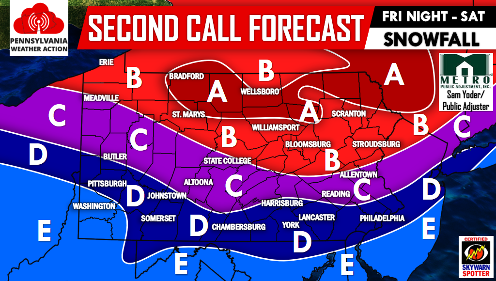
Second Call Snow Map
Area A: 6 to 8 inches of snowfall is expected. Heaviest snow Saturday Morning.
Area B: 4 to 6 inches of snowfall is expected.
Area C: 2 to 4 inches of snowfall is expected.
Area D: 1 to 2 inches of snowfall is expected.
Area E: A coating to 1 inch of snowfall is expected.
For future updates be sure to have us “liked” on Facebook by clicking here>>>>PA Weather Action on Facebook!
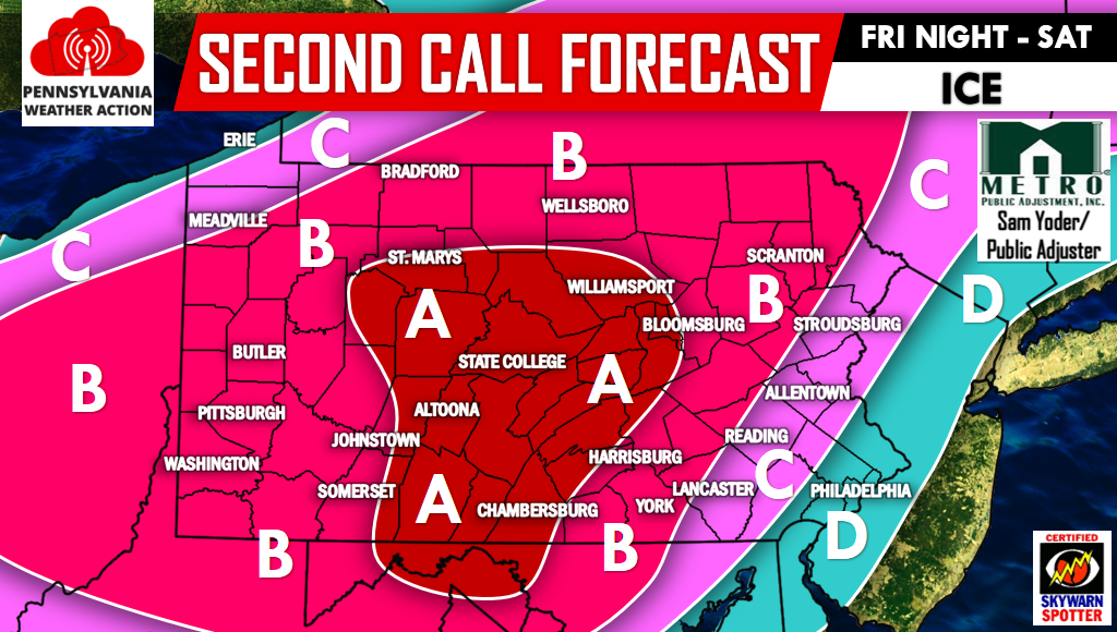
Be sure to scroll down after viewing this map. As stated earlier, significant ice accretion is expected.
Second Call Ice Map
Area A: 0.20-0.30″ of ice accretion on top of the snowfall accumulation. Scattered power outages likely.
Area B: 0.10″-0.20″ of ice accretion on top of the snowfall accumulation. Scattered power outages possible.
Area C: 0.03-0.10″ of ice accretion on top of the snowfall accumulation.
Area D: 0.01″-0.03″ of ice accretion on top of the snowfall accumulation.
Travel Impacts: Dangerous travel conditions likely into Early Saturday Afternoon likely in Areas A and B. State-wide disruptive travel impacts are likely beginning Friday Night and through Early Saturday Afternoon. If you have to travel, prepare for a slow go. Our advice is to have a plan B. This will be a nasty storm to have travel plans due to the combination of snow and ice.
Remember to share the Winter Storm details with your friends and family below, stay safe!
You must be logged in to post a comment.