


We are once again expecting another round of severe weather to pass through the state Tuesday afternoon and evening. A line of strong to severe storms are expected to develop to our west early Tuesday, and will push east hitting our western areas first early Tuesday afternoon and our central areas by the middle of the afternoon.
The line of strong to severe storms is expected to break up and weaken somewhat as it moves into eastern PA and is why many of these areas are not in the SLIGHT risk for severe weather.
Below is a video of our futurecast radar valid 11:00 AM Tuesday through 8:00 PM Tuesday which is as far out our futurecast radar forecasts through at this point. Be sure to click play:
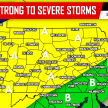
BELOW IS THE STORM PREDICTION CENTER’S FORECAST FOR TUESDAY:

Area A – The Storm Prediction Center has placed this area under a SLIGHT RISK for severe weather. Main impacts include damaging winds in excess of 60 MPH and torrential rainfall. With all the rain that has fallen in many locations this summer, flash flooding is also a serious concern for locations that get impacted by these storms Tuesday.
Area B – The Storm Prediction Center has placed this area under a MARGINAL RISK for severe weather. Main impacts include damaging winds in excess of 60 MPH and torrential rainfall. With all the rain that has fallen in many locations this summer, flash flooding is also a serious concern for locations that get impacted by these storms Tuesday.
Area C – Thunderstorms are possible Tuesday, but are expected to be below severe criteria.
If you do not already, be sure to like and follow our Facebook page for the latest updates regarding Tuesday’s severe weather and much more, click here>>>PA Weather Action on Facebook!
Make sure you share the news to prepare your family and friends about the severe weather using our icons below!

You must be logged in to post a comment.