
After a stretch of mild weather, we are tracking a potent coastal storm that will be impacting our weather in a big way come Sunday Night and into Monday Night. Over the last several days, Josh and I have been tracking this system and even though model guidance continued to show an all rainstorm, we discussed between ourselves the potential for this to turn on somewhat snowy. And sure enough, here we are a couple days later and model guidance has finally caught onto our ideas of a rain and snowstorm.
The current path this system is projected to take is for it to strengthen over the southern states, and then take a path northeastward right off Virginia Beach. As it turns up the coast, some guidance suggest it stalls out near Atlantic City, before moving away northeastward. This is a CLASSIC track for a big time snowstorm for PA in every other pattern. HOWEVER, we simply do not have cold air around as most of you know many of us are currently sitting in the mid 40s to even lower 50s. But, as this system strengthens between Virginia Beach and Atlantic City, a process called Dynamic Cooling will take place. Dynamic Cooling is caused by storm systems that produce their own cold air. And in this case, model guidance projects Dynamic Cooling to turn whatever rain is falling, into a very heavy wet snowfall for some areas of PA. What will also help with the Dynamic Cooling, is an ideal High Pressure placement in Southeastern Canada that will also help funnel in colder air and will create a block, prevent this storm to cut further inland.
Regardless of where you are in PA, precipitation will start off as rain Sunday Night. As the system develops into a strong coastal storm during the day Monday, areas mainly in the interior and/or high elevations will changeover to a heavy, wet snowfall. Based on currently guidance, Central PA through NEPA have the best chance at seeing the changeover occur.
With the strengthening coastal storm, winds will also increase. Winds will be much more of an issue along the coastal areas, however, even in Central and Eastern PA winds are capable of gusting 30 to 40mph..potentially higher. The combination of heavy wet snow on power-lines and trees and wind, could result in power outages.
GFS model valid 7 PM Sunday Night: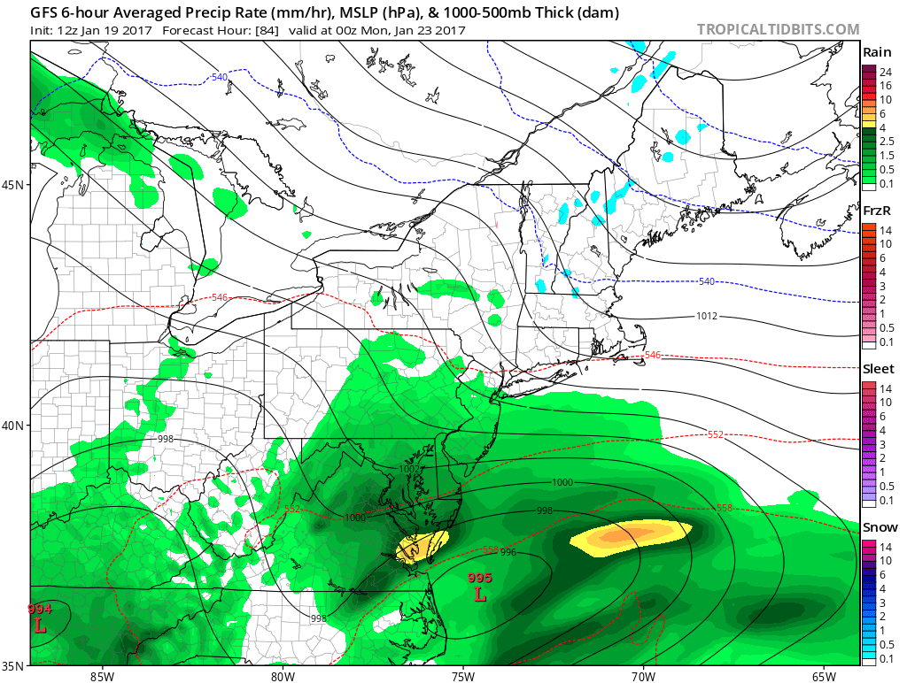 Again Sunday Night we will all start off as rain as shown above.
GFS valid late Monday Night: 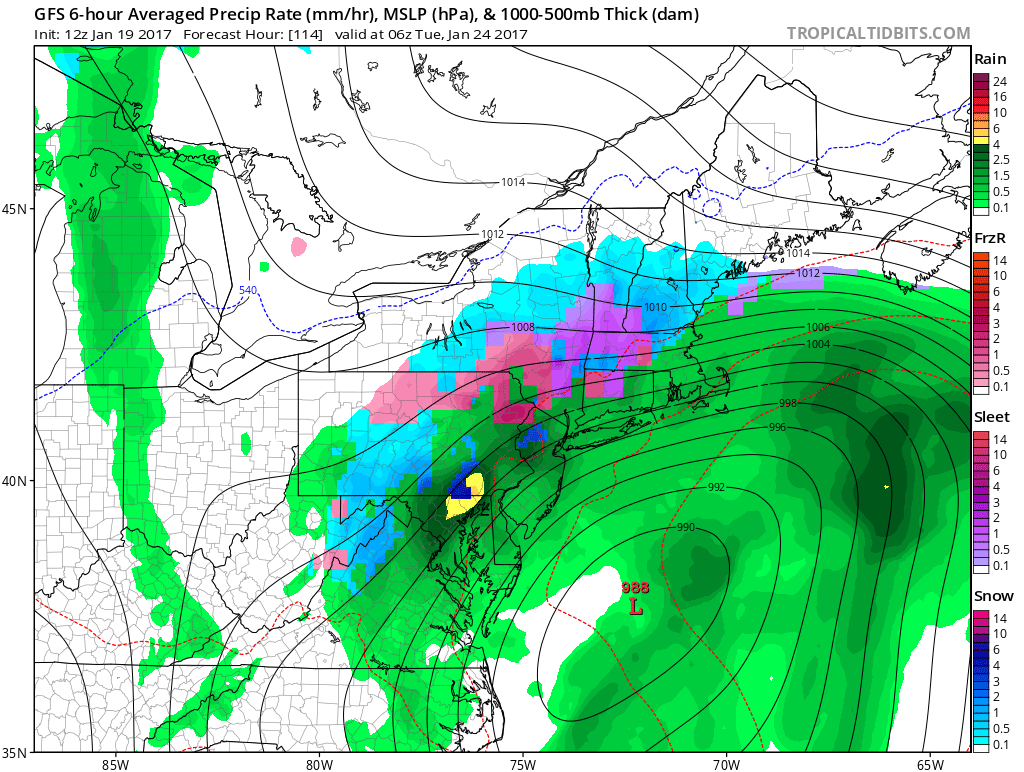
This is an extremely “dynamic” situation because of the Dynamic Cooling that is likely to occur. The reason you are seeing the precip type on this future surface map go from rain to snow to rain to snow to mix back to rain is because of the Dynamic Cooling that is taking place. Typically areas that receive the heaviest precip, will have the best chance of Dynamic Cooling taking place. And as mentioned earlier, the idea High Pressure placement in Southeastern Canada will help prevent this storm from traveling inland. IF that high pressure was not there, Dynamic Cooling would not be a factor and this would be an all rain event.
FIRST LOOK SUNDAY NIGHT INTO MONDAY
Timing: Rain will develop Sunday Night and will potentially changeover to a heavy wet snowfall during the day Monday, mainly for Central and Northeastern areas, before wrapping up perhaps as late as early Tuesday Morning. But the brunt of this storm looks like it will be on Monday.
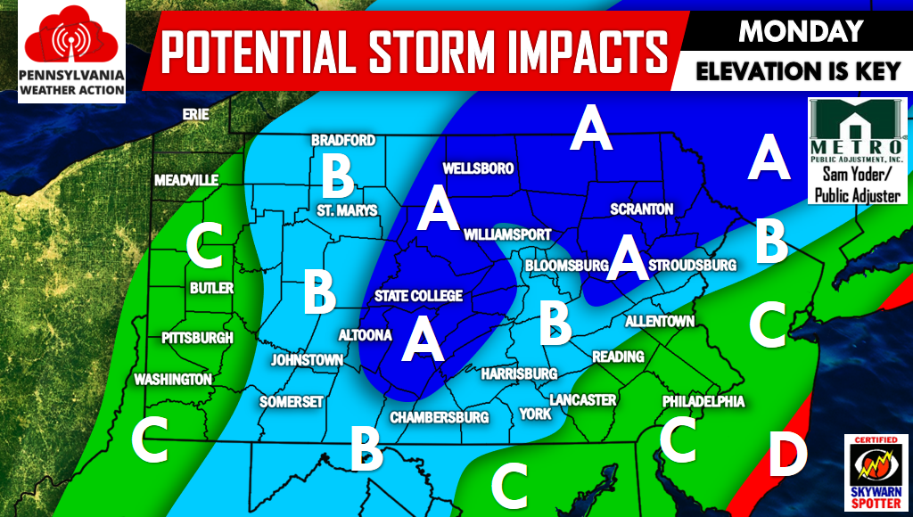
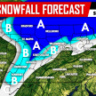
Area A – Significant snowfall possible Monday. Precipitation could start as rain or even possibly snow before changing to all snow especially in areas above 1000′ elevation.
Area B – Precipitation will start as rain Monday Morning and afternoon before potentially changing over to snow in the late afternoon, continuing into the night. There is the possibility for light to moderate snowfall especially in areas above 600′ elevation.
Area C – This area is likely to see mainly rain out of this system. If models continue to trend colder areas like Allentown and Reading could be looking at the chance of snow but for now we’re expecting primarily rainfall in those locations.
Area D – The intensity of this storm is likely to result in beach erosion and coastal flooding. Wind gusts over 60 MPH will be possible.
We will have our First Call Forecast out Friday with snowfall amounts and more.
Make sure to have our Facebook page liked for the latest as we track this powerful coastal storm, click here>>>>PA Weather Action on Facebook! Also share this forecast with the icons below!
You must be logged in to post a comment.