
5:00 PM FRIDAY: Final Call Snowfall Forecast Posted:
Final Call Snowfall Forecast for Saturday’s Quick-Hitting Heavy Snow
March weather is known for throwing curveballs, and it does not get any more textbook than starting a week with severe storms and ending is with a near-blizzard conditions. This is not your typical system where the low pressure passes by and cold air wraps in from behind, but struggles to change low elevations to snow. Instead, a very strong cold front will already be blowing through just as precipitation gets going in many areas, with the low pressure still to our southeast. However it will certainly depend where you are in the state. The two biggest factors right now are whether or not the low pressure is elongated, and exactly when that front pushes in. The European model currently has a more stretched out low pressure, causing broader but weaker precipitation. Almost all other models have a tighter low pressure center.
Yes, this storm is going to come after another warm day. Yes, the snow will fall during the daylight hours for many of us. But neither of those things will really matter. First, when places change from rain to snow and temperatures drop into the low 30s, snowfall rates will be 1-2″ an hour. That will result in accumulation on all surfaces. Afterwards when snow begins to lighten, there will already be snowpack and temperatures will be in the 20s and even 10s in the mountains. Treated roads will likely still see accumulation in areas that see a changeover to heavy snow, which will be most of the state. Areas that see more rain (far SEPA), will see a rapid freeze potentially creating a thin layer of ice.
To make matters worse, winds will be sustained 15-25 MPH, with gusts to 45 MPH for several hours as the front goes through. That will result in very poor visibility and isolated power outages, which crews will have a tough time restoring for a while given the conditions.
TIMING
Rain will change to heavy snow Saturday morning generally from west to east, and this changeover will not be dependent on elevation. Perhaps there could be a 20 minute difference between a mountain and neighboring valley, but this has more to do with the upper levels rather than the surface. Snow will be heaviest directly after the changeover (1-2″/hr rates in Central & Eastern PA), and gradually lighten in the following hours. Just how long that period of snow is after the changeover will depend where in the state you are. Below is future radar for the storm.
FIRST CALL SNOWFALL FORECAST FOR SATURDAY
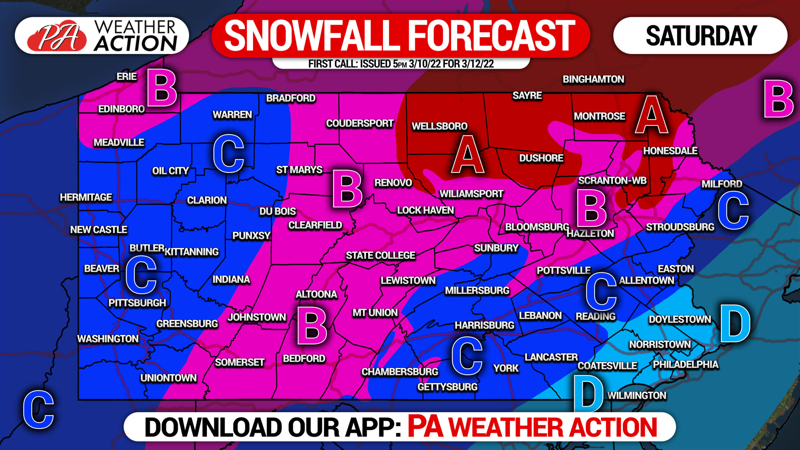
Area A: Snowfall accumulation of 8 – 12″ expected. Snowfall rates of 1-2″/hour likely during the changeover, along with wind gusts of 35-50mph. Travel will be very difficult to near-impossible Saturday morning through late afternoon.
Area B: Snowfall accumulation of 5 – 8″ expected. Snowfall rates of 1-2″/hour likely during the changeover, along with wind gusts of 35-45mph. Travel will very difficult to near-impossible Saturday morning through late afternoon.
Area C: Snowfall accumulation of 3 – 5″ expected. Snowfall rates of up to 1″/hour (western side), 1-2″/hour (eastern side) likely during the changeover, along with wind gusts of 30-40mph. Travel will be very difficult during snowfall (view future radar).
Area D: Snowfall accumulation of 1 – 3″ expected. Snowfall rates of 1″/hour likely during the changeover, along with wind gusts of 30-40mph. Travel will very difficult late Saturday morning through late afternoon.
Our Final Call will be posted Friday afternoon, stay tuned for that. There is a bit of increased uncertainty with this storm currently.
Be sure to share this important forecast with family and friends who may have plans Saturday!
[social_warfare]
Follow the storm and our latest updates, 11 map layers, and more with the PA Weather App!

Follow us on social media:
Facebook: https://www.facebook.com/paweatheraction
Twitter: https://twitter.com/paweatheraction

You must be logged in to post a comment.