Since starting PA Weather Action nine years ago, every single winter has ended with above average temperatures overall. Will we get our tenth consecutive winter of warmth relative to average? To find the answer to that question, we must look at where things stand here in mid November as we near the beginning of meteorological winter.
There are several big indicators around the globe that are correlated with certain weather patterns in North America. Most are correlated with sea surface temperature anomalies in different parts of the Pacific Ocean, as the Pacific Ocean plays a large role in our weather directly downstream.
La Niña Impact on Our Winter
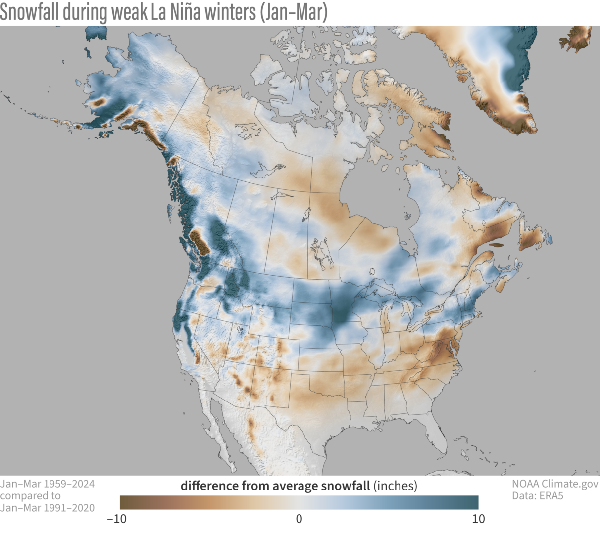
You may have heard that a La Niña is likely for this winter. While that wouldn’t be the best news for snow lovers in most of Pennsylvania, the good news is that it’s likely to be very weak. We continue to struggle to officially reach a La Niña, and it’s not expected to get much stronger.
The less of a La Niña we get, the better things will probably be in terms of snowfall. And when we say better, we mean more. It’s just a natural tendency, so bear with us. Below is a graphic from NOAA showing snowfall compared to average during weak La Niña winters. It’s not a pretty picture for snow lovers south of I-80.
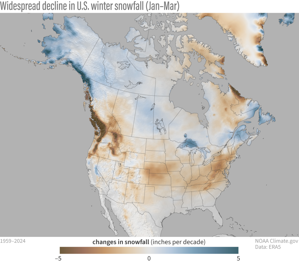
While winters have gotten warmer since the 1980s especially, the share of decreased snowfall hasn’t been equal even around the northeast. The I-95 corridor had many great winters in the 2000s and 2010s, while that wasn’t the case as much in the interior across the Appalachians. But with weaker high pressure to our north and warmer ocean temperatures off the coast, storms recently have been favoring the interior for greater snowfall amounts.
Check out the differences in average winter snowfall in much of Pennsylvania since 1959, per decade. That’s an average loss of 10-20″ of snowfall per winter now versus back then! So when you hear people say, “winters these days aren’t like they used to be”, it’s true!
Meanwhile as Arctic high pressure has lost its grip in Canada over the decades, they are getting more snow in many areas due to more precipitation being available.
PDO Impact on Pennsylvania Winters
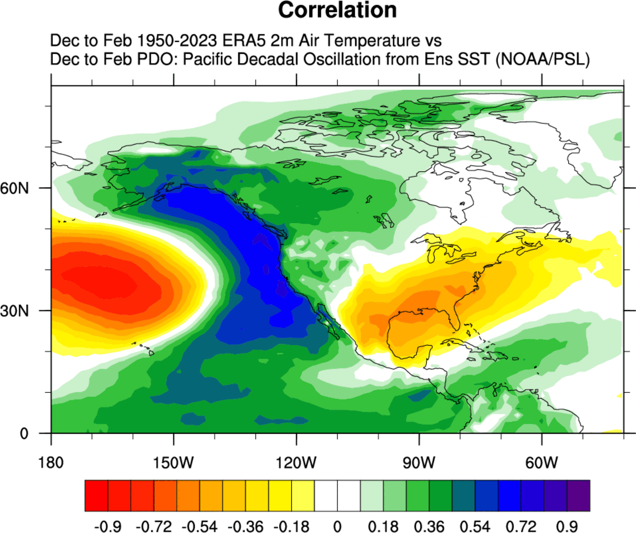
The second most important indicator for winter is the Pacific Decadal Oscillation, or PDO. It’s an area of sea surface temperature anomalies in the North Pacific, and depending on how anomalies are oriented determines if it’s in a positive or negative phase. It’s currently off the charts negative, which is great news if you’re cheering for another dud winter in Pennsylvania.
A negative PDO is correlated with southeast ridging, or high pressure in the Southeast US that also results in warmer than average temperatures and a lack of snowfall in PA. Meanwhile, troughing and colder than normal temperatures typically occur out west and into the Midwest. Below is a graphic showing a typical negative PDO temperature anomaly map for winter. The yellow and orange mean warmer than normal.
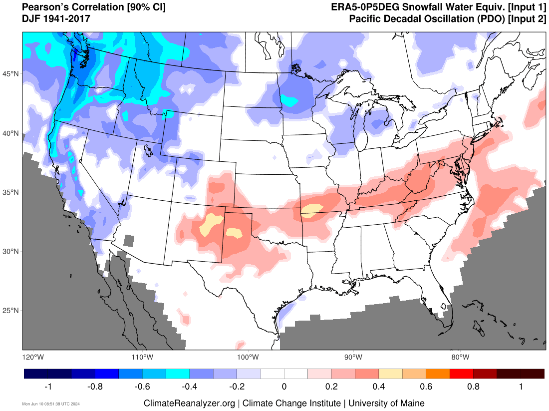
And when you look at snowfall, you do not get a pretty picture in much of the state especially south of I-80 once again. Below is a graphic showing a negative PDO’s impacts on snowfall during winter, with red meaning below average. It’s a great look in the Pacific Northwest and even Northern Great Lakes for snow lovers.
Top Analog for the Upcoming Winter
Analogs, or winters with similar sea surface temperature anomaly setups, play a significant role in our winter outlook. We like to use winters within the last two decades, which factors in a warmer climate now versus the 1900s. By far the season that stands out the most is 2016-2017. It was a weak La Niña winter coming off the heels of a strong El Niño, which is the exact setup for this year.
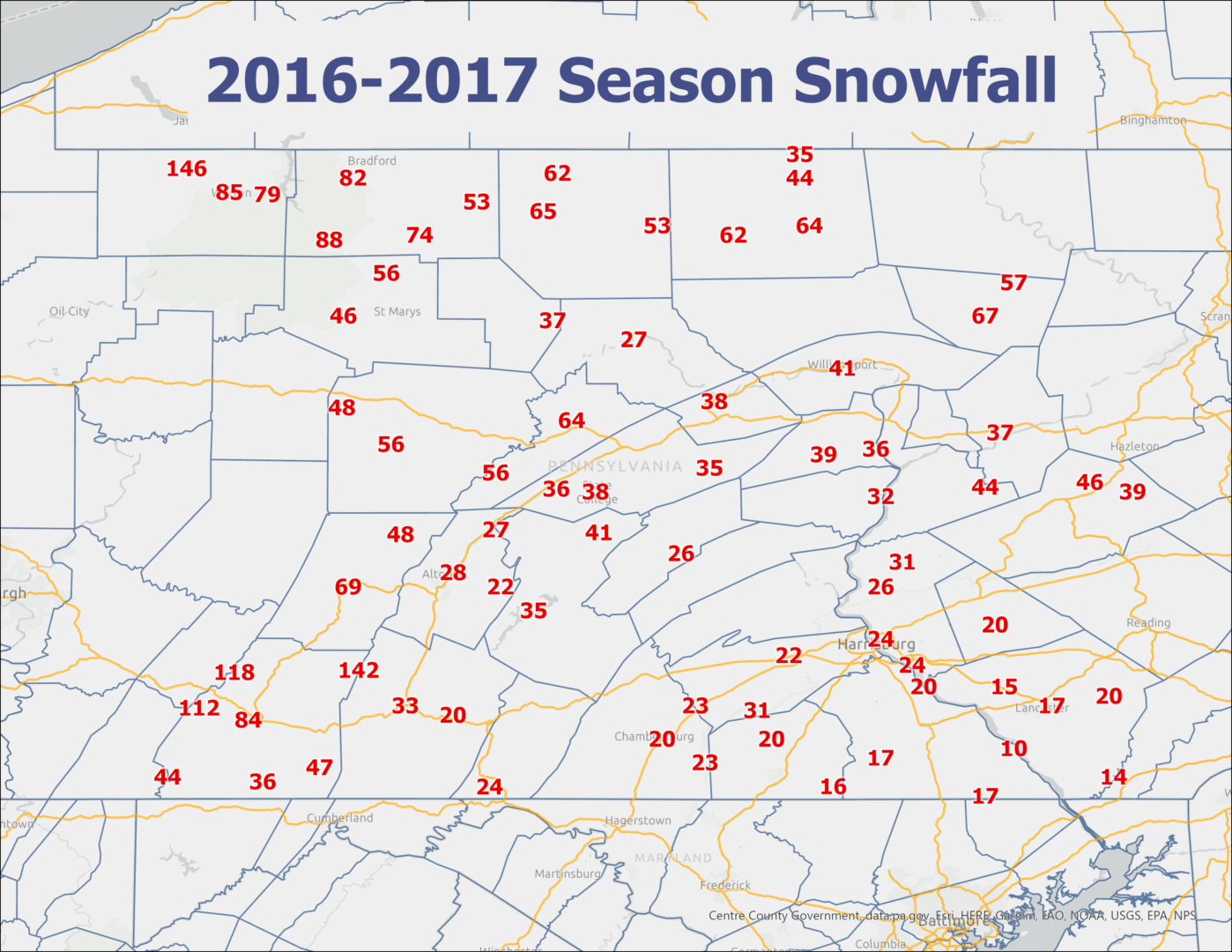
That winter ended up having above average temperatures, but there were well-timed snowfall events especially near and north of I-80, as you will see below. This map shows snow totals in Central PA for the 2016-17 winter, with most places seeing near average snowfall.
2024-2025 Winter Outlook
It’s a bit difficult to be optimistic in the face of so many worrisome indicators that signal we are likely in for another lackluster winter.
The big question is whether this is the new normal, and to that I would say I don’t think so. Western North America has done well the last 5 years in terms of snowfall, even in lower elevations. While the maximum potential of our winters may not be what it was in the 1960s and 70s, I do think we will break this streak soon and return to snowier winters for a time.
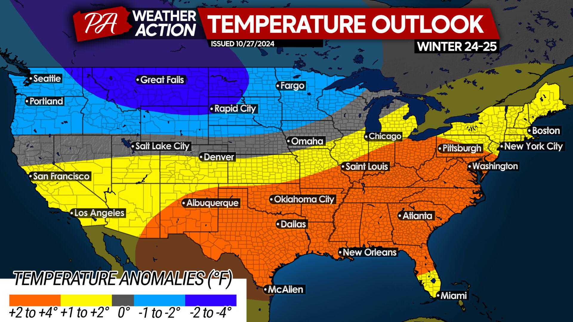
2024-25 Winter Temperature Outlook
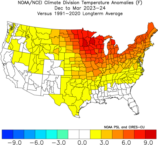
While this may look very warm and even worse than last winter, it’s actually a much better look than last winter. With the raging El Niño, we had no cold air source at really any point. Here is how last winter went in terms of temperature anomalies. While we predicted slightly above average temperatures for last winter, Pennsylvania averaged around 5 degrees above average for the season, which is well above.
A mild holiday season is expected once again, but don’t be surprised if we get a wintry mix or two especially in the interior. After that, the details for each month become fuzzy. We predict January to be our wintriest month, with potentially an early spring.
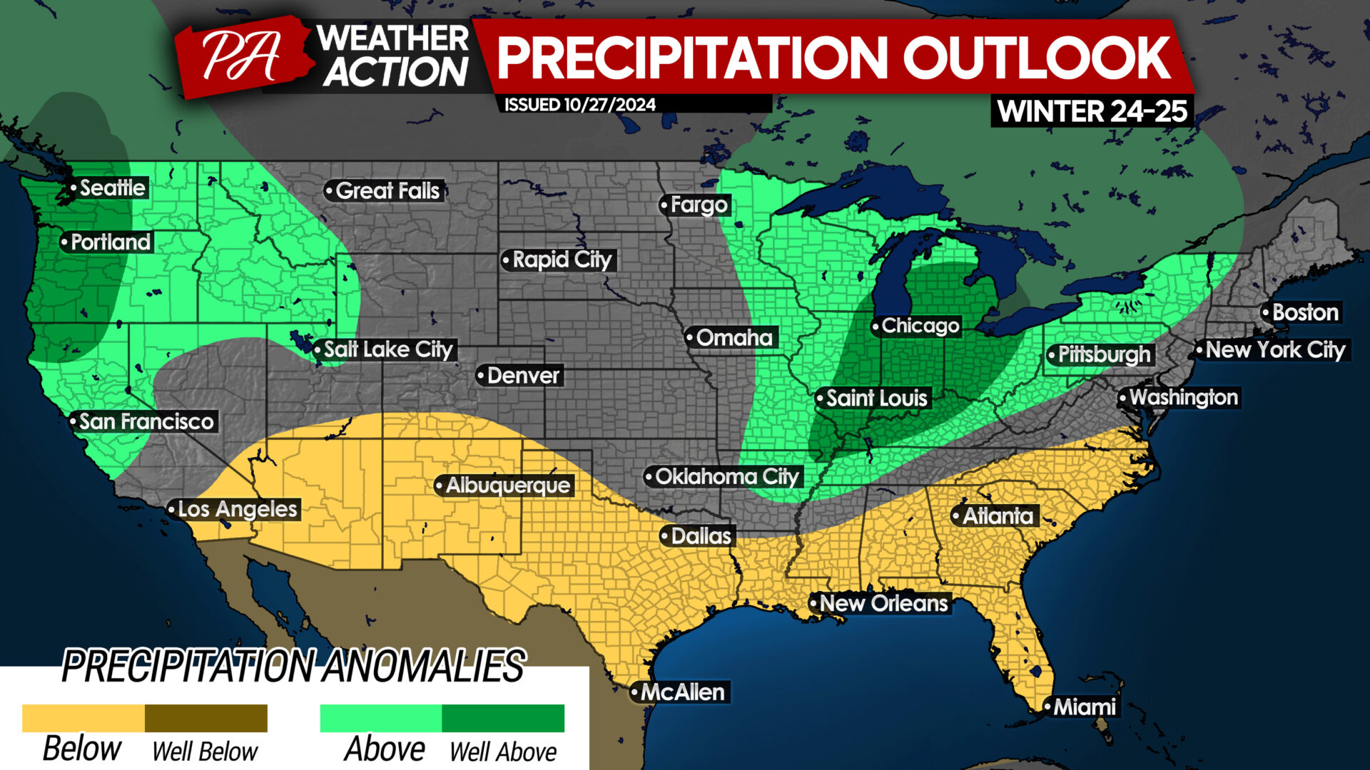
2024-25 Winter Precipitation Outlook
This is unexpectedly an outlook that many people care about as we approach winter, our driest season, already in severe drought in many areas. The pattern is starting to get more active, but it will likely take into December before it completely breaks down. However, we are less confident about this forecast as La Niñas often favor high pressure in the southeast.
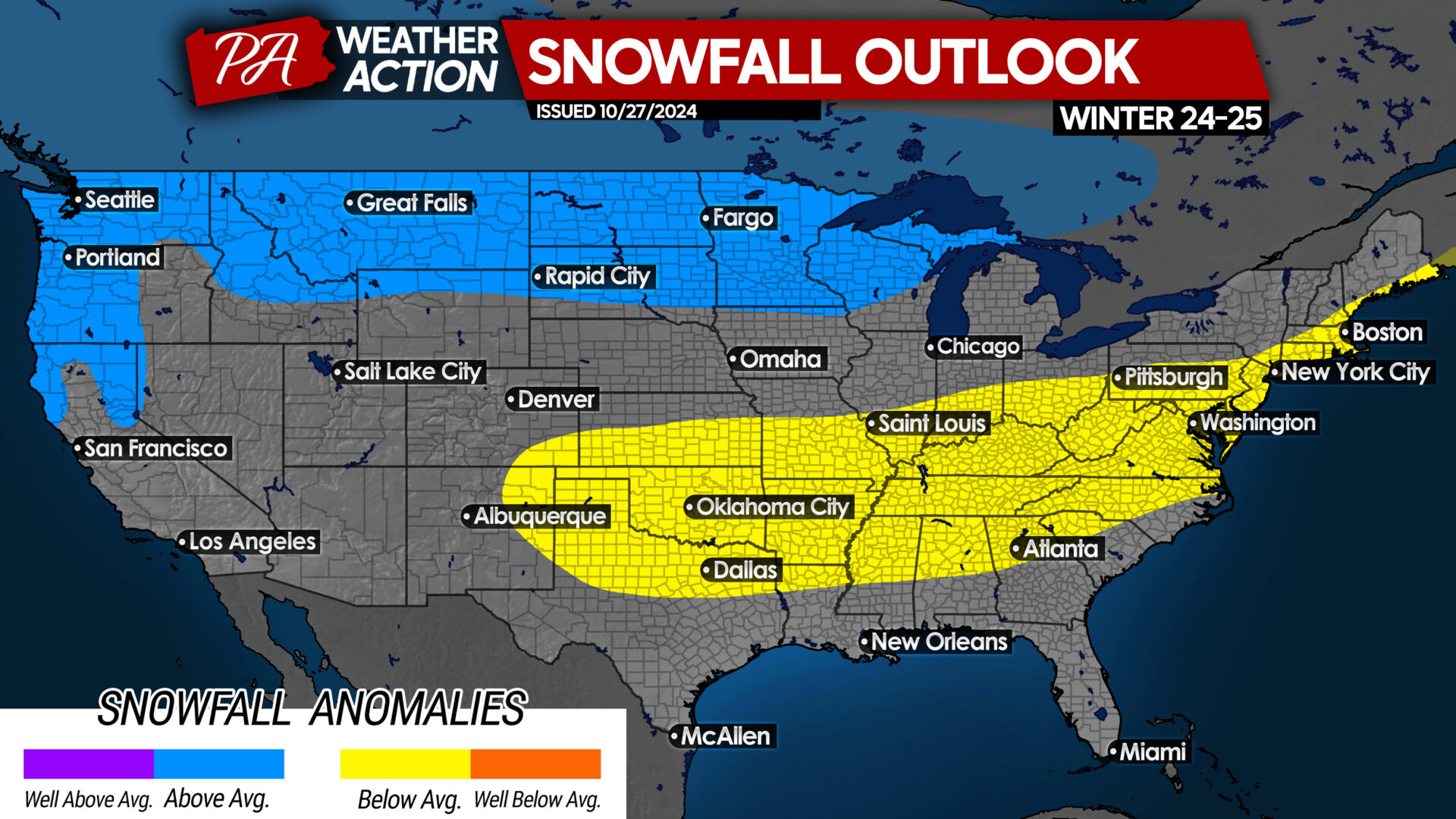
2024-25 Winter Snowfall Outlook
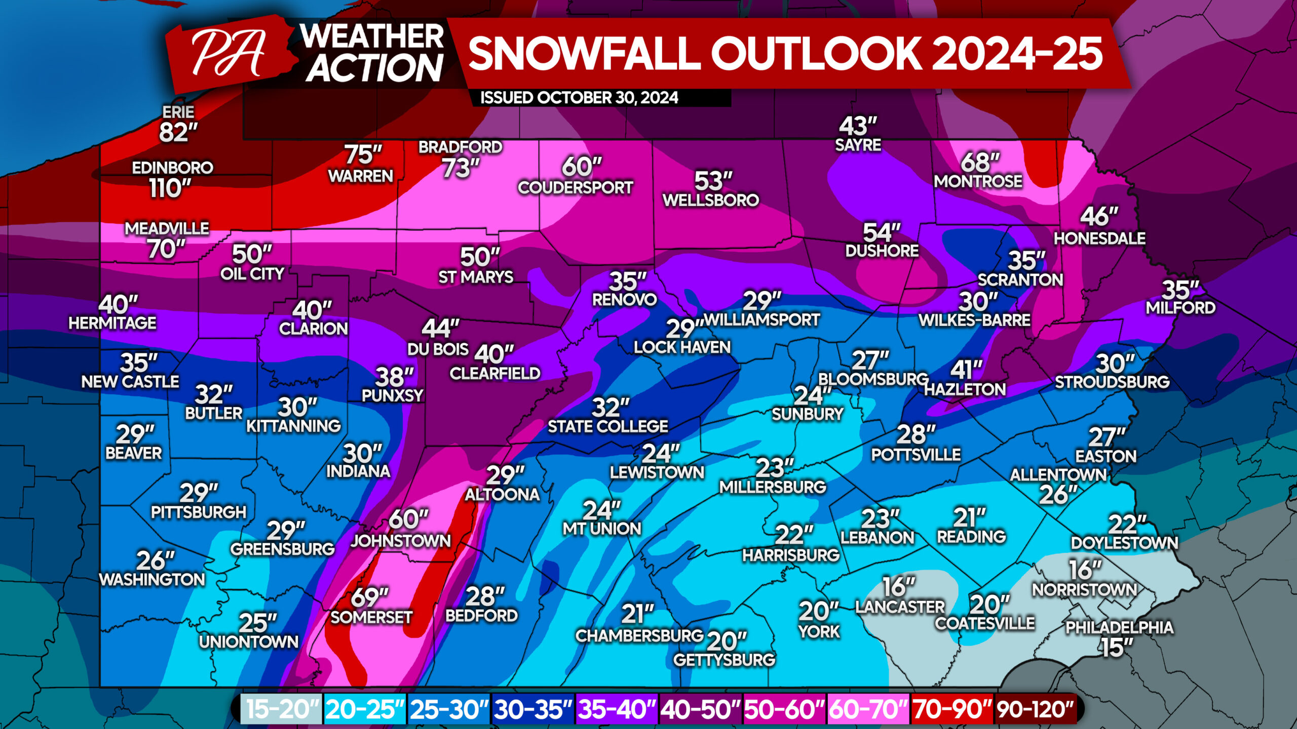
Based on a variety of factors, some of which we mentioned above, we expect below average snowfall in the southern two-thirds of Pennsylvania. But when compared to last winter, we anticipate winter snow totals to be slightly higher – which isn’t saying too much.
You may be wondering how much snowfall your area averages per winter, and you will find the answer to that in this article:
Average Snowfall in PA: From 18 Inches to Over 12 FEET Of Snow, Where Does Your Town Rank?
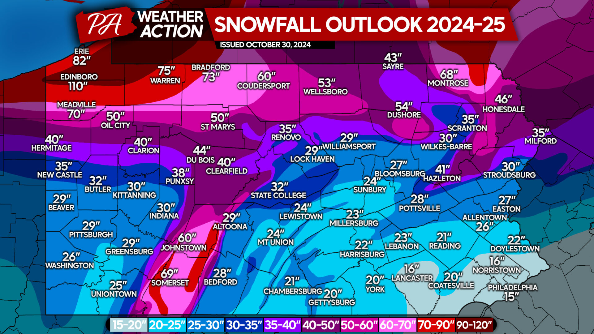
2024-25 Winter Snowfall Outlook in Pennsylvania
Near-normal snow is expected in Northern Pennsylvania this winter, with the snowiest town in Pennsylvania, Edinboro, coming in at 110″, which is a bit less than usual for them believe it or not. And the least snowy city, Philadelphia, is forecast to come in at a measly 15″ for the winter, which would be around 66% of average.
We expect many storms to be from northern stream energy, which tends to run more west to east. As a result, the rain/snow line will often be latitude-based instead of running down the coast or the Appalachians. This shouldn’t be a problem for north of I-80, whereas in Southern PA it will be especially if Canadian high pressure is weak, allowing storms to come farther north.
Don’t forget to share this article with any snow lovers in your life, whether friends of family!
It won’t be long before we are predicting winter weather in the near-term, so be sure to give us a follow if you haven’t yet!


You must be logged in to post a comment.