
For the first time in nearly a decade, last winter brought below average temperatures. Still, the season left snow lovers with much to be desired. Drier conditions than normal led to many missed opportunities, especially east of the mountains.
In fact, Philadelphia and New Orleans received the same amount of snow during winter 24-25. That was not a favorable metric, considering Philly averages 108x more snow than New Orleans a year. Will this season be different?
Biggest Drivers of the Winter Season
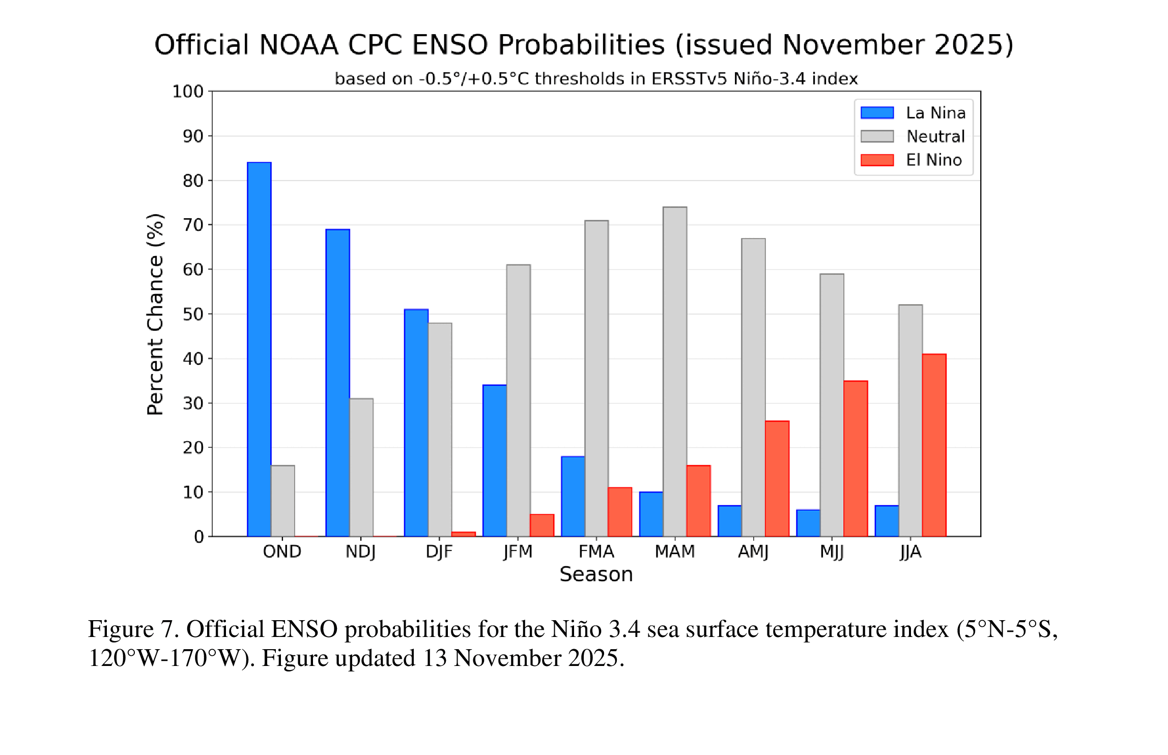
La Niña has managed to establish itself well, with latest readings in the ENSO region about -0.7C. The threshold is -0.5C for a Weak La Niña. We look to stay weak, before moving below that threshold into a neutral phase by the end of winter. Getting a move to neutral by February will be crucial for saving the second half of winter.
The strongest signals for a colder winter season are a -NAO/AO regime and a weakened polar vortex, partly due to an easterly QBO. The EPO is also showing signs of favoring its negative phase. These indicators suggest more troughing and below averages temperatures in PA.
The biggest signal for a warmer season is the -PDO, which has done more harm than good in the last decade. A -PNA is also a potential, which may knock down the western ridge and prevent blockbuster snowstorms.
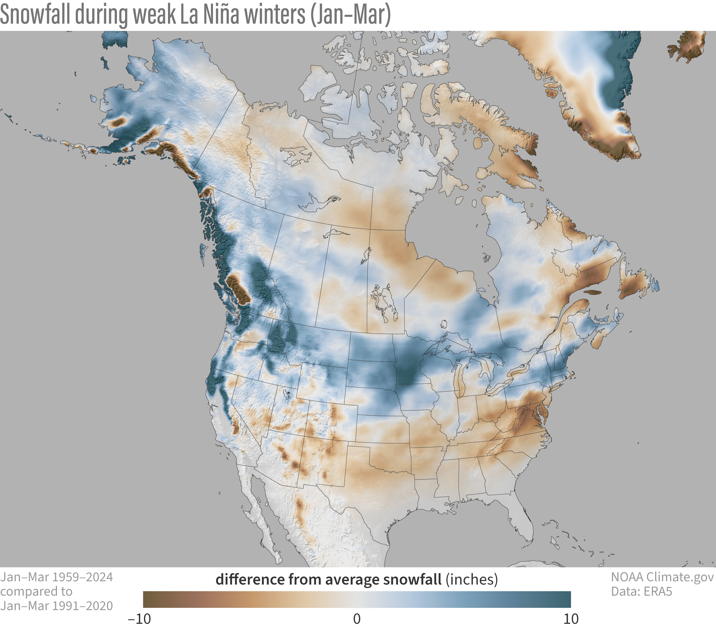
We would also preferably have kept La Niña even weaker or have been in a neutral ENSO phase. Pennsylvania averages its highest snowfall during neutral to Weak El Niño winters, with only Northern PA at an advantage during La Niña. Average snowfall departures during Weak La Niñas are shown below.
Analogs Favor Colder Than Normal Temperatures
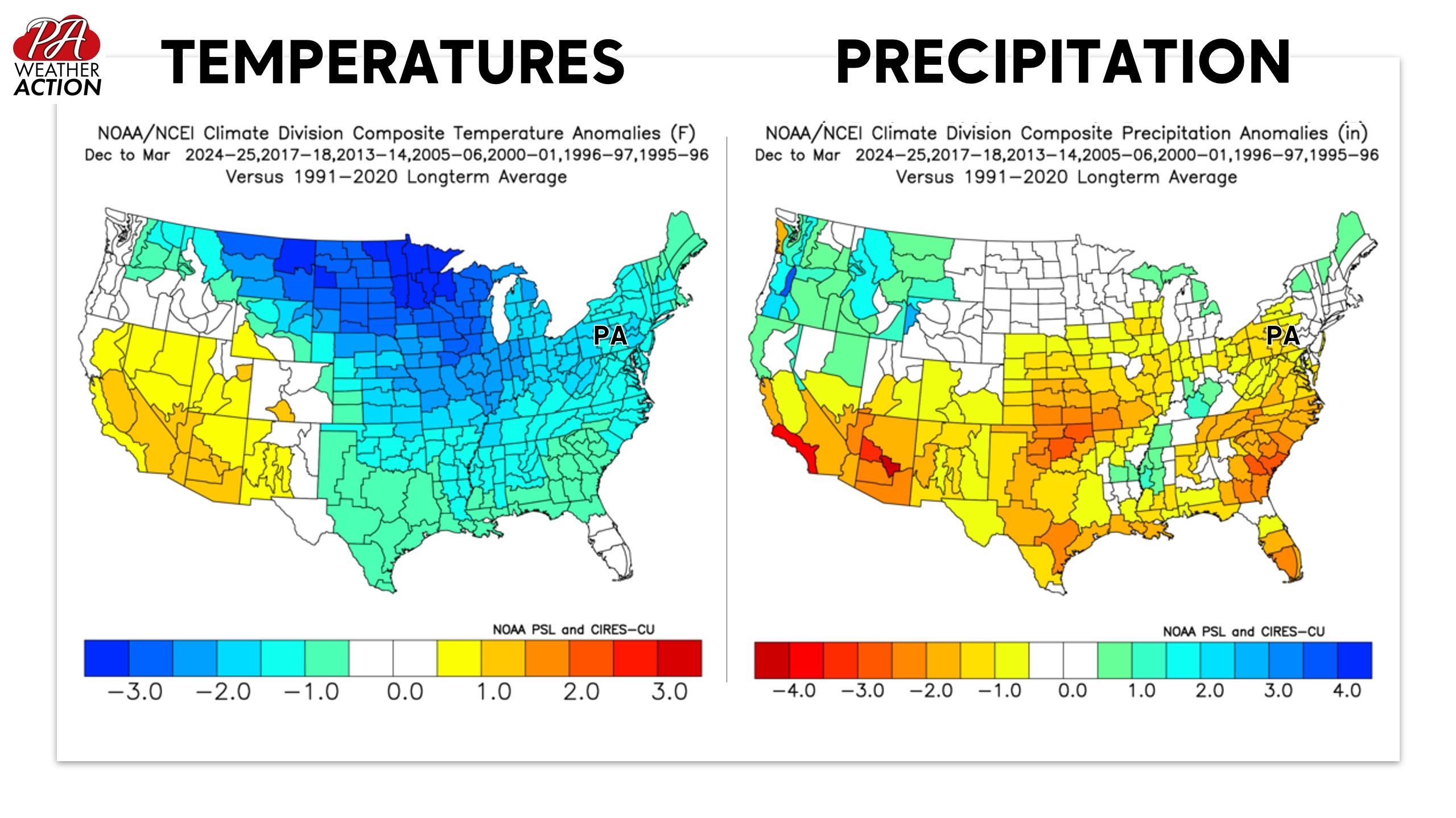
We have seven winters in the last 30 years that look reminiscent of current global conditions, and most of them produced below average temperatures. There are some very notable winters such as 1995-96 and 2013-14, but also some mundane seasons.
As far as precipitation, parts of Pennsylvania are favored to be slightly below normal. This is common when winter is on the colder side, drier Arctic air and high pressure to our north have more of an influence.
Fast Start to Winter, Then Mixed Signals
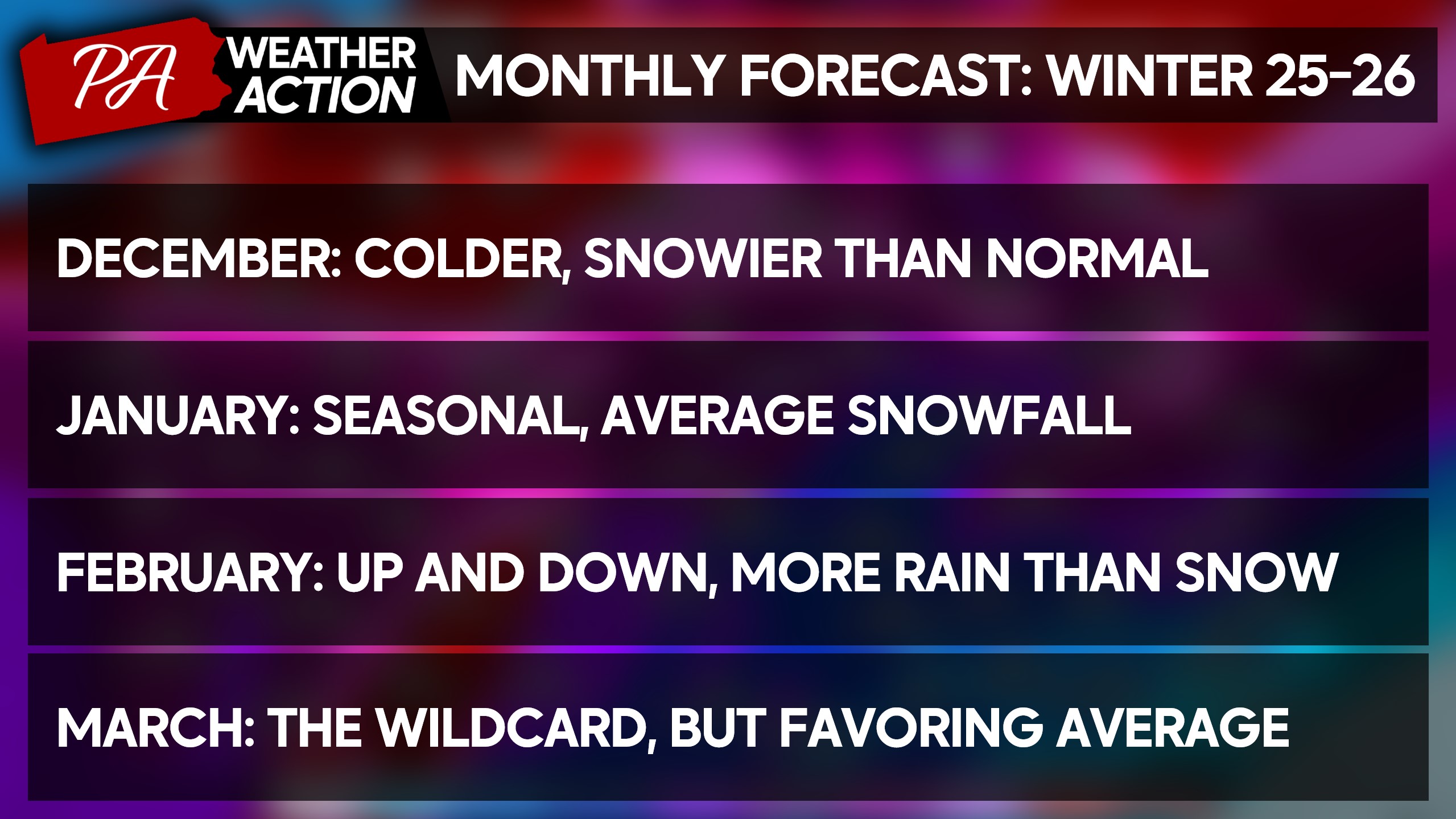
A warm end to November will be followed by flip head first into winters, with everything pointing toward a colder than normal December with opportunities for winter storms. Between talk of an early season stretched polar vortex, a phase 7 MJO, a -EPO/NAO/AO, it’s nearly a guarantee.
January is when we expect the cold air to dig deep, infiltrating well south into the US. But as we say last year, too much of a good thing can become a problem. January may be on the drier side once again, but the potential exists for larger coastal storms.
February all comes down to the anticipated weakening of La Niña. If we reach neutral ENSO conditions, February could continue the cold and potentially snowy streak from the first half of winter.
But we think the infamous southeast ridge, a classic player on the field during La Niña, will harm PA snow chances in the month of February, while areas to our north cash in on storms that travel over our heads and transfer to the coast. We’re more likely to see messy storms come February.
Analogs heavily favor a colder than normal March, which would be a surprising reversal from February that we haven’t seen much lately. However March 2018, a top analog for this season, brought multiple major winter storms to our area. March is a month up for grabs, and we’re splitting the difference.
2025-2026 Winter Outlook
Only one of the last six winters brought above average snowfall, which has felt like such a reversal from the snowy 2010s. But this winter, we see less standing in the way of at least an average winter. I think a lot of us have forgotten what average is, which can be found here.
A cold first half of winter, followed by a February thaw and then perhaps back to normal in March should yield a more traditional winter overall. And we aren’t so far displaced from the snowy winters of the 2010s to believe they are just a relic of the past.
2025-26 Winter Temperature Outlook
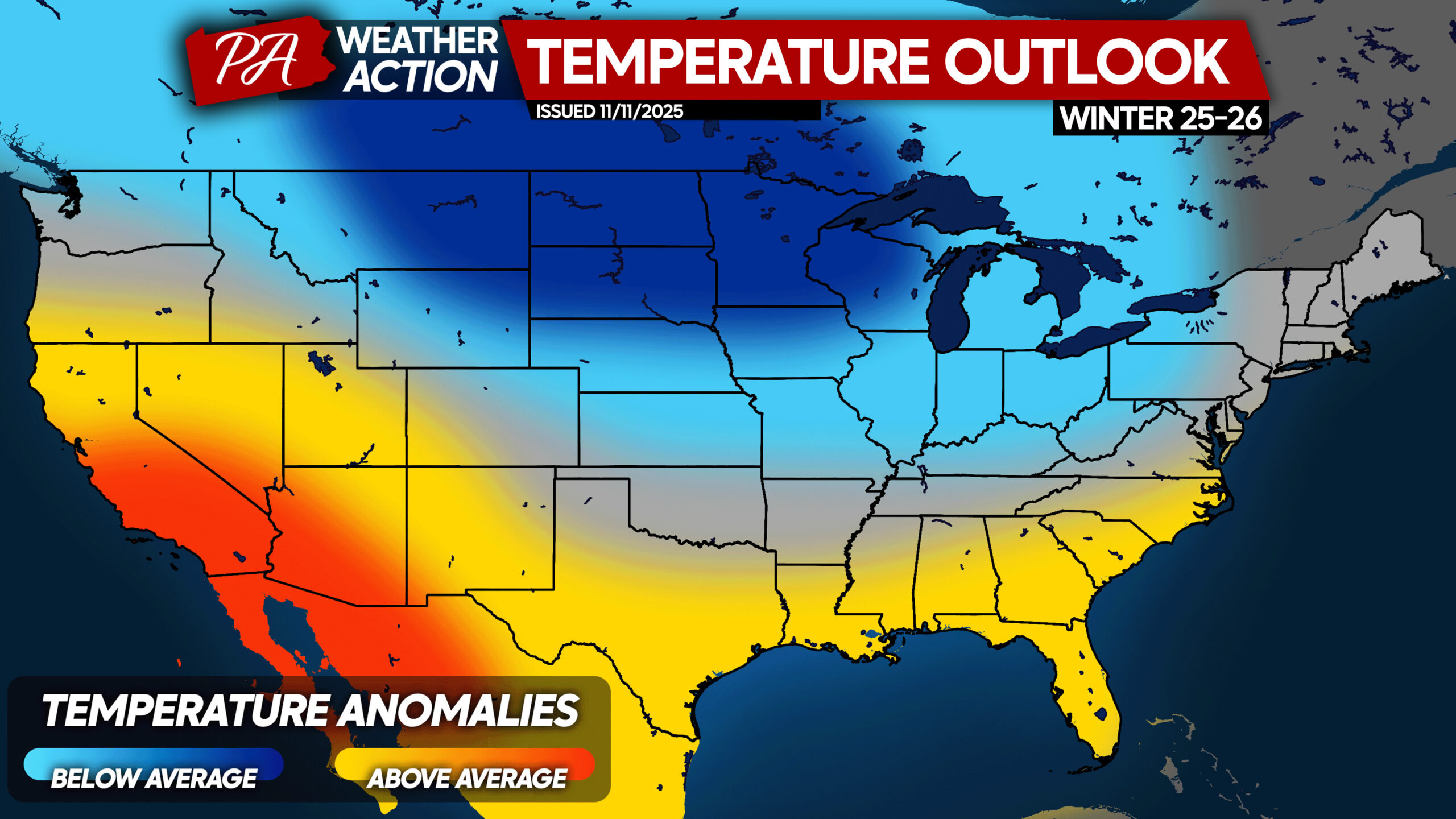
Overall from December to March, we are calling for temperatures to be similar to last winter. Last winter was about 2° below average as a whole, and this winter I think we will be about 1-2° below average.
Areas closer to the coast may be near average, as they tend to torch most as we see systems cut to the west. This should be most common in February. On the flipside, very cold air is probable in December and much of January.
2025-26 Winter Precipitation Outlook
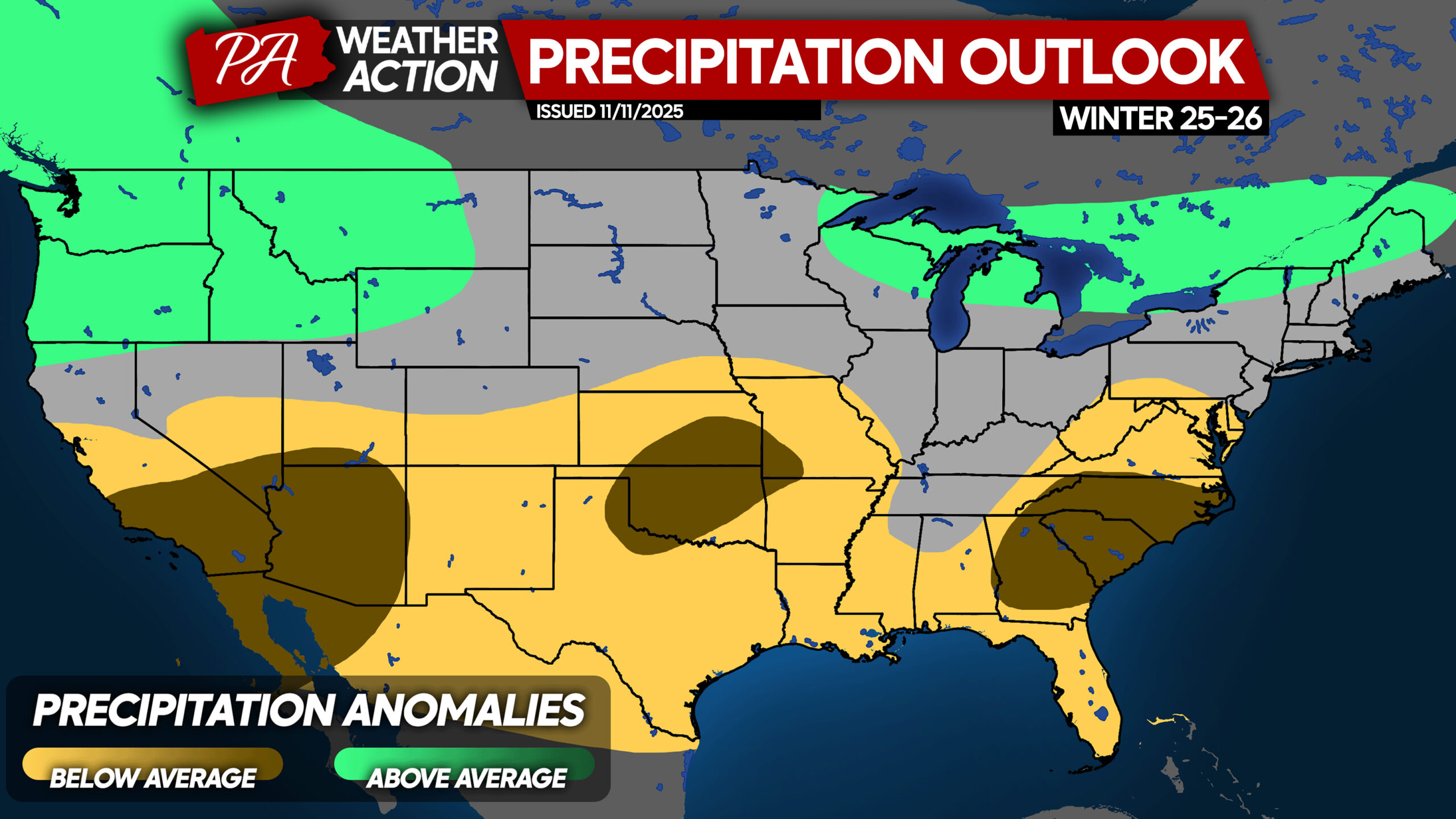
Average to slightly below average precipitation is anticipated this winter in Pennsylvania. This is mainly based on analogs, and is a partial biproduct of Arctic air intrusions which never bring precipitation with them outside of the lake effect regions.
The northern stream will be more dominant, which benefits areas more to our north. It also doesn’t have as much precipitation to work with, versus in El Niño when we see storms pick up Gulf moisture.
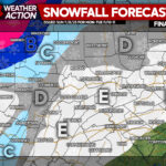
2025-26 Winter Snowfall Outlook
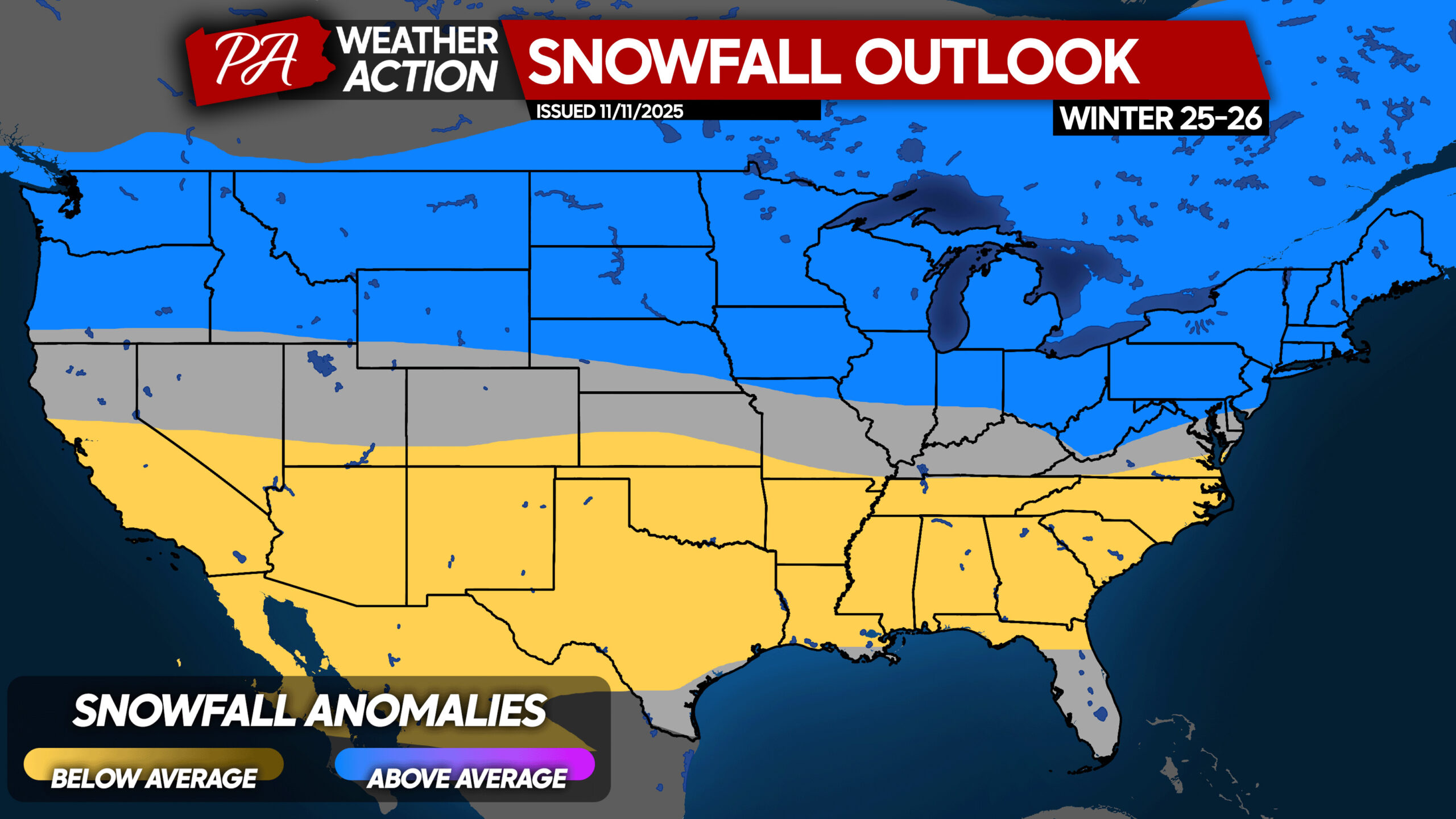
Slightly below normal temperatures play a huge role in this snowfall forecast. Last winter was a rarity, and we don’t expect a repeat of so many missed opportunities. This will be a winter about latitude, similar to 2017-18.
The Northern US as a whole is favored to see above average snowfall, with an area of average to the south. The Southern US can expect less snow than normal. Pretty clear cut!
2025-26 Winter Snowfall Outlook in Pennsylvania
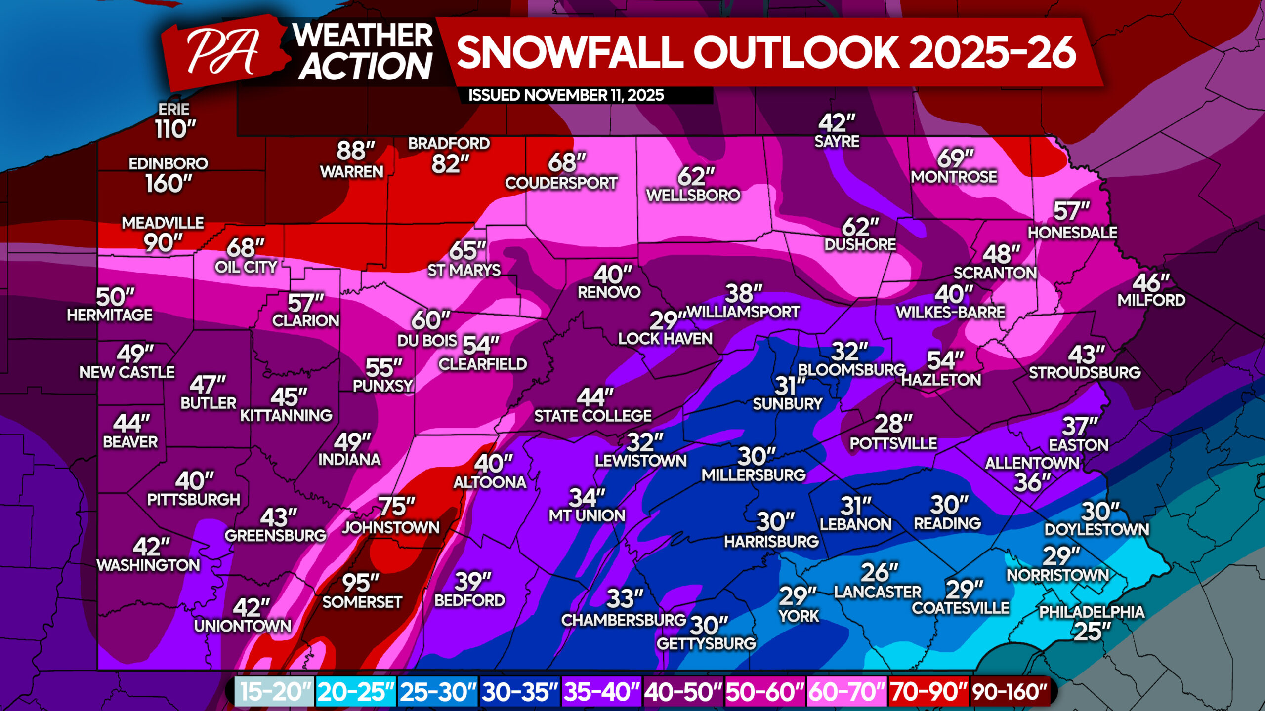
Last winter, our seasonal snowfall forecast was pretty accurate, a solid B+. We look to repeat that success again with this one. We always base our forecast on data rather than hope!
There has been much talk of below normal snow on the coast this winter, but we don’t agree! The average seasonal snowfall of our analogs in Philadelphia is an impressive 32.8″, which is well above average.
In fact, the mean snowfall among our seven analog winters was average to above average everywhere in Pennsylvania. And with the first half of winter already looking very favorable, we are forecasting average to slightly above average snowfall.
Don’t forget to share this article with any snow lovers in your life, whether friends or family!
You must be logged in to post a comment.