
The Storm Prediction Center has labeled much of the state under a slight or enhanced risk of severe thunderstorms for Monday (5/1). An organized line of storms ahead of an approaching cold front will move across the state from west to east Monday Afternoon and Evening.
A few isolated cells ahead of the main line have the best potential to produce a tornado in Central PA. However, the highlight of the day will be a widely impacting line of severe thunderstorms. The greatest threat with this line will be damaging winds of 60-70MPH. Here is a timeline of the anticipated line.
STORM PREDICTION CENTER RISK MAP
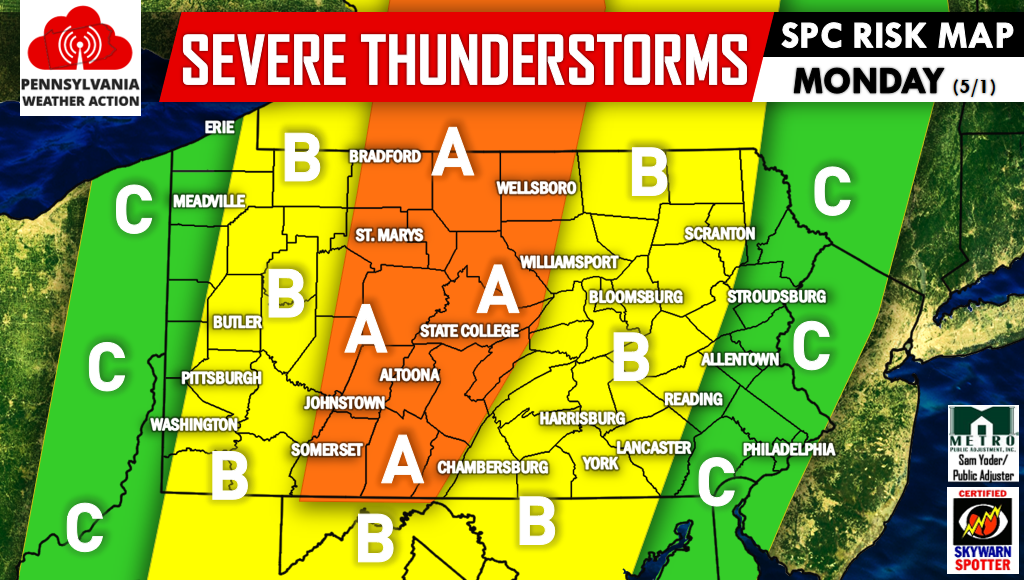
Area A – Enhanced Risk: Severe thunderstorms will include damaging winds and scattered hail when moving through this area. The majority of locations within this risk zone will be impacted. An isolated tornado cannot be ruled out.
Area B – Slight Risk: Severe thunderstorms featuring mainly damaging winds will move through this area. Locations most at risk are east of Pittsburgh, Butler, and Washington, and west of Gettysburg, Harrisburg, and Scranton.
Area C – Marginal Risk: Strong storms will be form in far Western PA early Monday Afternoon. In Eastern PA, “the leftovers” of the mentioned line of storms will move through the area late Monday Evening.
We will be posting watches and warnings on facebook. Click Here to Like Us on Facebook. Also, track the storms with interactive radar and more on our app, Click Here to Download Our New App. Be sure to warn your friends and family of the expected severe weather using the icons below. Stay safe!


You must be logged in to post a comment.