
Only slight changes have been made to Tomorrow’s forecast, but overall the general theme remains the same. This will not be a big event. The precipitation that falls Tomorrow will be on the light side and any accumulations of snow and/or ice will be light as well.
Timing: Precipitation will begin in Western PA in the mid-morning hours Tomorrow and then around lunchtime for Central and Eastern PA. The precipitation may start off as a brief period of snow, especially farther north in pa, before changing to sleet and freezing rain later in the afternoon. We expect everyone to change to a plain rainfall by midnight Wednesday Morning.
Final Call Forecast
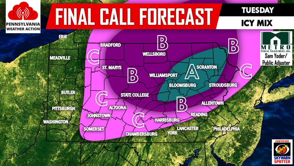
Area A – An hour or two of sleet and/or snow before a several hour period of freezing rain. Ice accretion between .10-.20″ expected. Slick travel is likely.
Area B – An hour or two of sleet and/or snow will lead to a few hours of freezing rain. Ice accretion between .05-.15″ expected. Slick travel is likely.
Area C – A few hours of freezing rain are likely before temperatures rise above 32. Ice accretion between .02-.10″ expected. Slick travel is possible.
Make sure to click here to follow us on Facebook for more updates>>>>PA Weather Action on Facebook! Also don’t forget to share the forecast below.
You must be logged in to post a comment.