While Northern PA is off to a fast start this winter with Scranton at over 15″ on the season, most of Southern PA is still searching for their first inch of snow. And it appears that search will have to continue, as once again this system looks to only hold promise for snow in the high elevations.
A deepening low pressure system will move over the state on Wednesday amidst it’s northeasterly track, bringing heavy rain and strong winds to the eastern half of the state. A line of thunderstorms is even possible! On the backside of the low, cold air will be rushing in and will likely change rain to snow in some places.
Cold temperatures will come rushing in Wednesday night, with many areas stuck in the 20s on Thursday and dipping into the teens by Friday morning. But of course we will warm up by the weekend as another storm tracks to our north, likely producing another round of rain on Sunday.
Storm Timing
As moderate to heavy precipitation falls around lunchtime Wednesday, the cold air will begin to crash on the backside of the system. Rain is likely to change to snow across Western PA by early Wednesday afternoon. Temperatures will be above freezing, so road impacts are likely to be minimal.
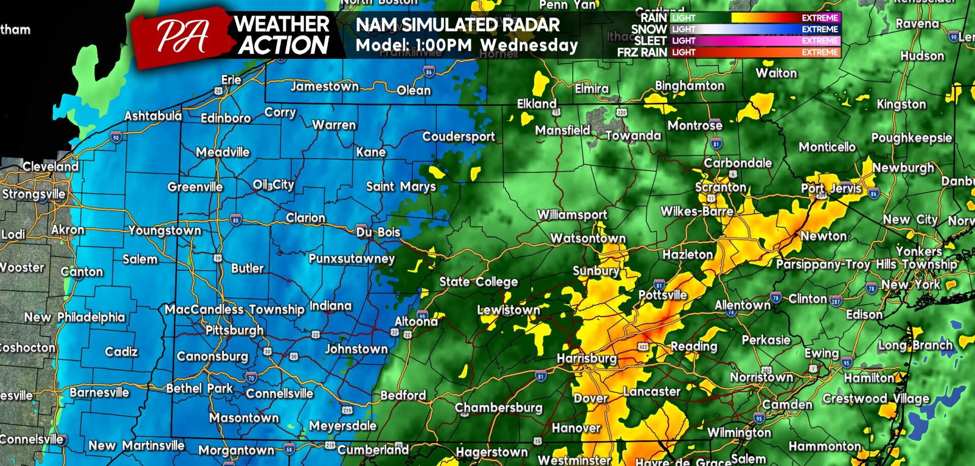
A line of thunderstorms will also begin to develop around 1 PM Wednesday, with gusty winds up to 50 MPH possible as this line pushes from west to east. Below is Hi-Res NAM Future Radar for 1:00 PM Wednesday.
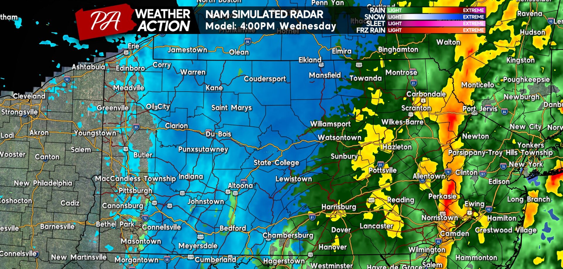
Heading into late Wednesday afternoon, snow will shut off around the I-79 corridor. Meanwhile the rain/snow line will continue pushing east, with elevations above 1200′ changing over before the surrounding valleys. By 4:00 PM, the rain/snow line will likely be in the ridge and valley section of Central PA.
Snow may begin to accumulate on roads by this time above 1600′ elevation after a few hours of moderate snowfall. This will be in the Alleghenies and ridge tops across Central PA.
The squall line fill push into the Philadelphia Metro around this time, with wind gusts as high as 50 MPH. Here is Hi-Res NAM Future Radar for 4:00 PM Wednesday.
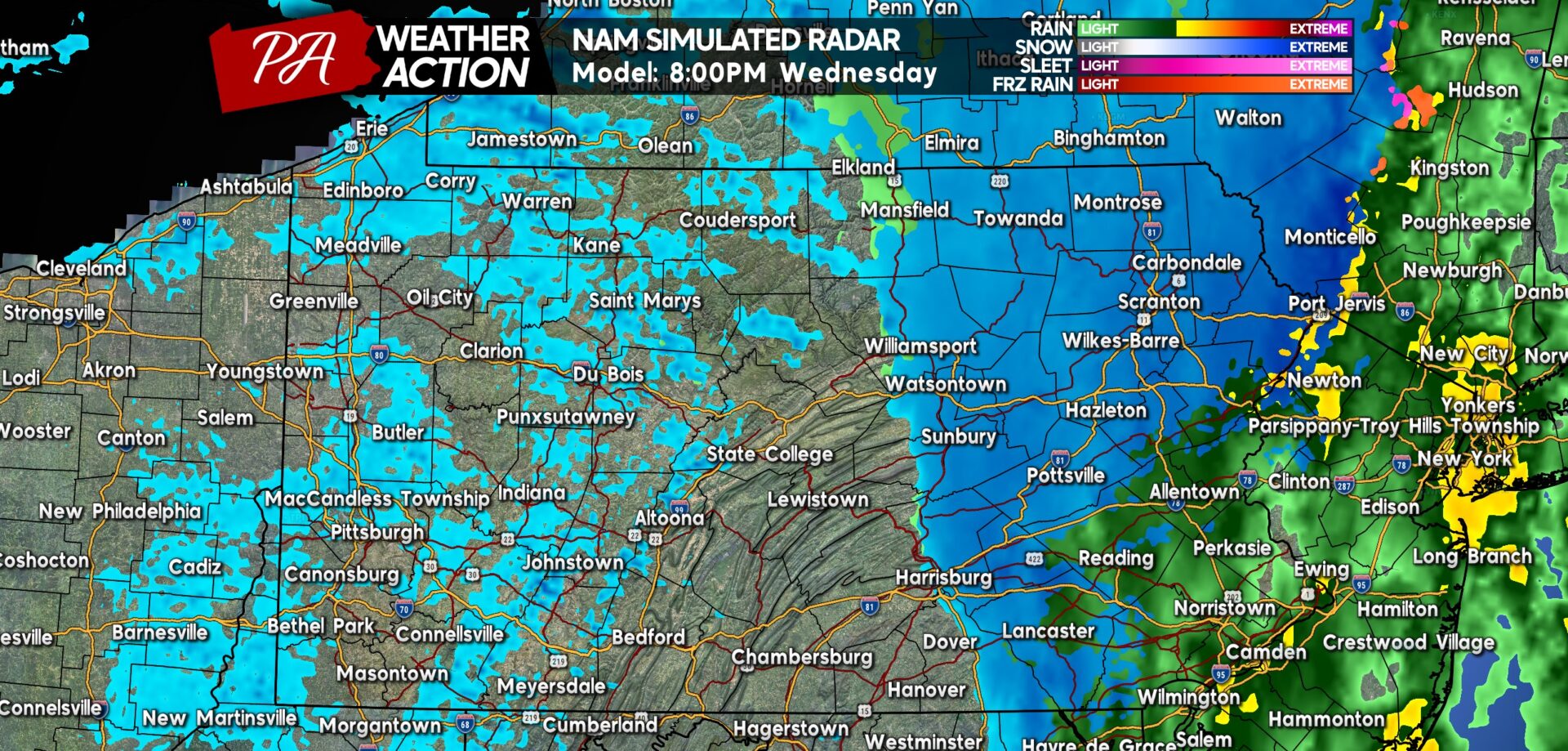
By Wednesday evening, a few lake effect snow flurries will be flying in Western PA as the cold air settles in. Out in Eastern PA, rain will change to snow in the Poconos and Endless Mountains.
The changeover may occur in Susquehanna Valley, but no impacts will be felt as festive flakes may briefly fly as the tail end of precipitation exits. Below is future radar for 8:00 PM Wednesday.
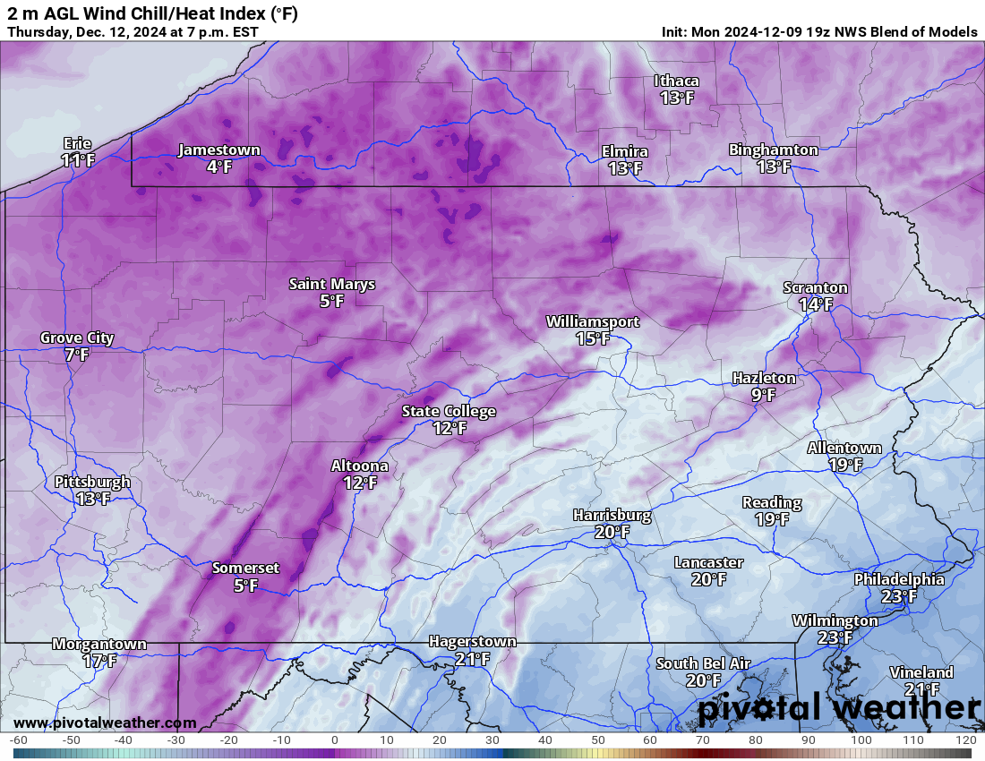
After precipitation clears out, a deep chill will come rushing in. Wind chills on Thursday will range from the single digits in the Alleghenies to low 20s in Southeast PA. Check out these wind chills for 7:00 PM Thursday.
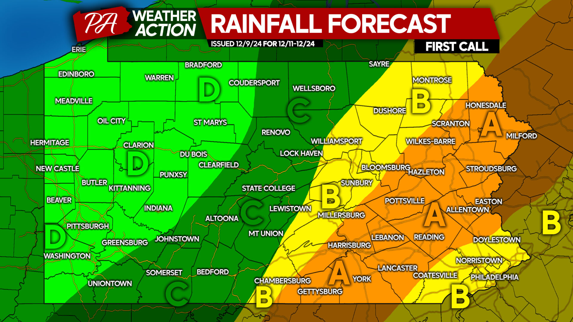
RAINFALL FORECAST THROUGH THURSDAY
While the majority of this will fall as rain, a bit will fall as snow. That precipitation has also been included here.
Area A: Rainfall accumulation of 1.5 – 2.0″ expected.
Area B: Rainfall accumulation of 1.0 – 1.5″ anticipated.
Area C: Rainfall accumulation of 0.5 – 1.0″ expected.
Area D: Rainfall accumulation of 0.2 – 0.5″ anticipated.
This rainfall will greatly help drought conditions, but not fix them entirely.
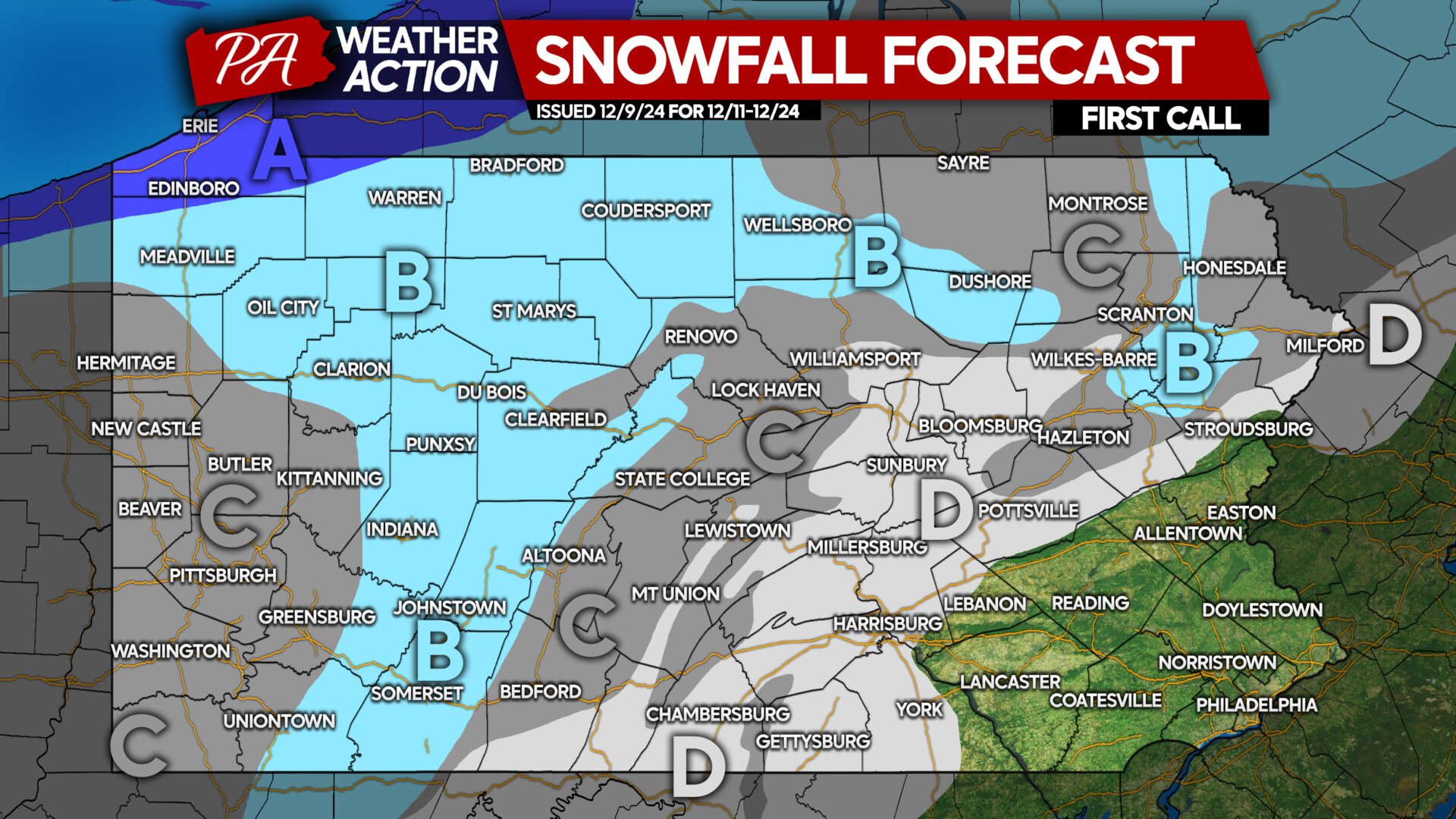
SNOWFALL FORECAST FOR WEDNESDAY INTO THURSDAY
Area A: Snowfall accumulation of 3 – 7″ expected. Road conditions may be deteriorated during times of lake effect snow Thursday morning.
Area B: Snowfall accumulation of 1 – 3″ anticipated. Road conditions may become slushy after a few hours of moderate snow.
Area C: Snowfall accumulation of less than 1″ expected. No roadway impacts likely.
Area D: Snow showers possible at the very end of the storm Wednesday, but no accumulations are expected.



You must be logged in to post a comment.