
FINAL CALL FORECAST POSTED:
While very few of us will have snow on the ground Christmas morning, Winter Storm Watches are up ahead of the season’s most impactful storm so far. Unfortunately it’s going to be more of a mess than anything, with snow, sleet, ice, and rain all on the table.
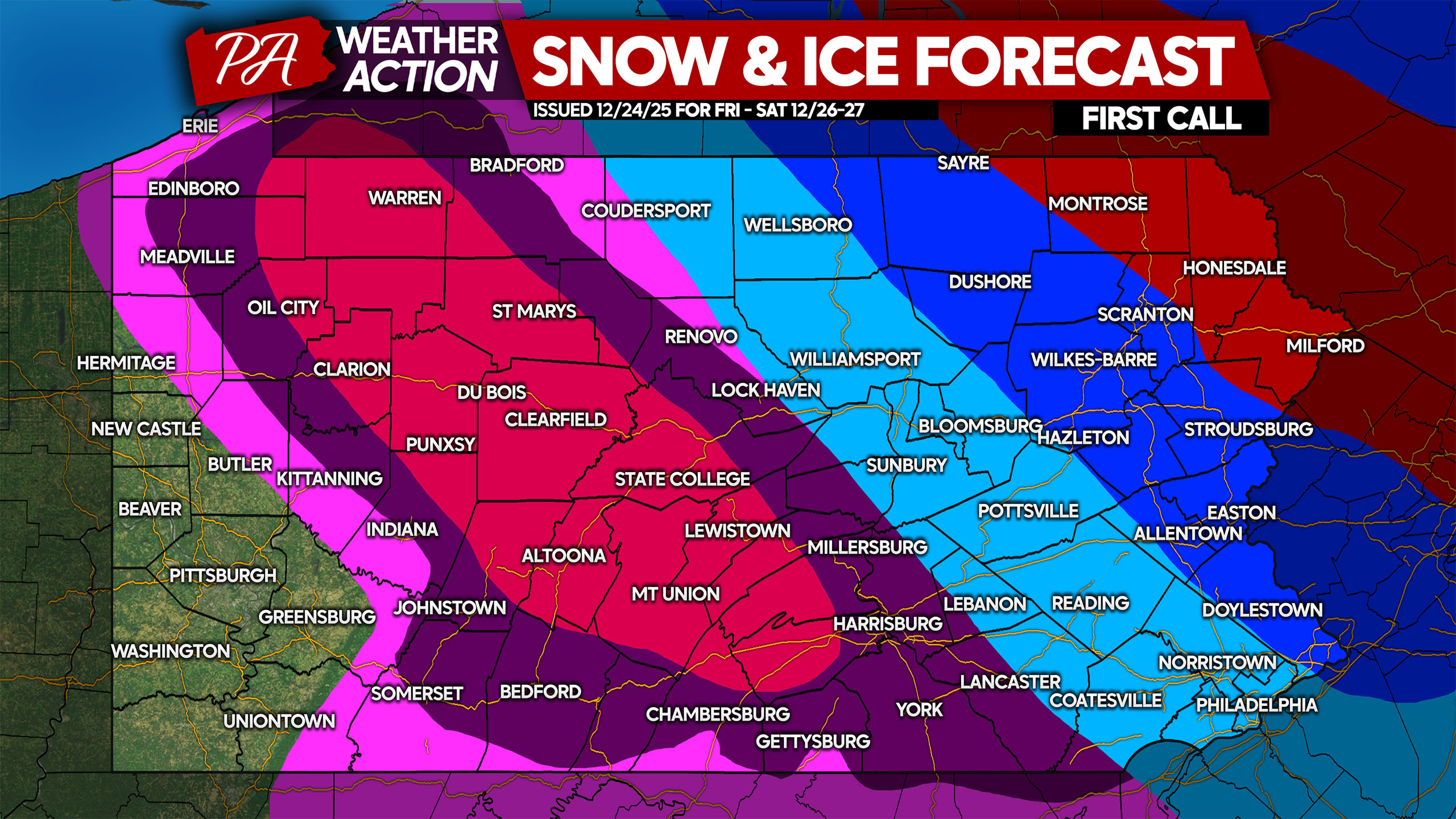
As mentioned in yesterday’s first look, only Northeast PA is likely to stay all snow. The Lehigh Valley and Southeast PA will start with a period of snow before changing to sleet and even freezing rain. Central PA will be a sheet of ice, along with Northwest PA. In places without cold air damming, namely Southwest PA, a harmless rain event is on tap.
Freezing rain is often overlooked by most people for not being as dramatic as snow, but its effects are worse. It’s easy to venture outside and immediately fall during freezing rain!
WINTER STORM TIMING (EURO MODEL)
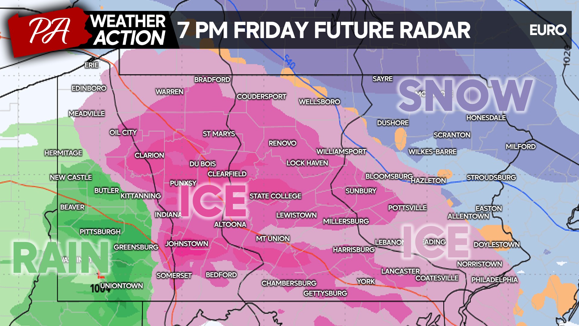
The storm will push in from west to east early Friday afternoon, bringing rain in Southwest PA and freezing rain (ice) to Northwest PA just after lunch. Light snow will begin to the east across North Central PA.

Road conditions will rapidly deteriorate across Northwest and Central PA late Friday afternoon as ice makes surfaces very slippery. I wouldn’t recommend walking outside much starting from this point. Below is future radar on the Euro model for 4:00 PM Friday.

Most of us will be staying in Friday evening, as the worst of the ice and snow will be between 5-11 PM Friday. The goal is to avoid falls on the ice which may then require driving on ice. It’s a better idea to not go out until things warm up Saturday afternoon.
The pink represents ice, and it encompasses a large portion of the state. Northeast PA and perhaps areas of SEPA along the Delaware River (Northampton & Bucks County) will be seeing snow around 7 PM Friday.
Snow will continue along the Delaware River late Friday evening, with freezing rain (ice) still an issue across Central and Southeast PA.

And finally by early Saturday morning, the storm will begin to exit to the east off the coast. Light snow and ice is still expected in the pre-dawn hours. By sunrise, the storm should be over and off the coast.
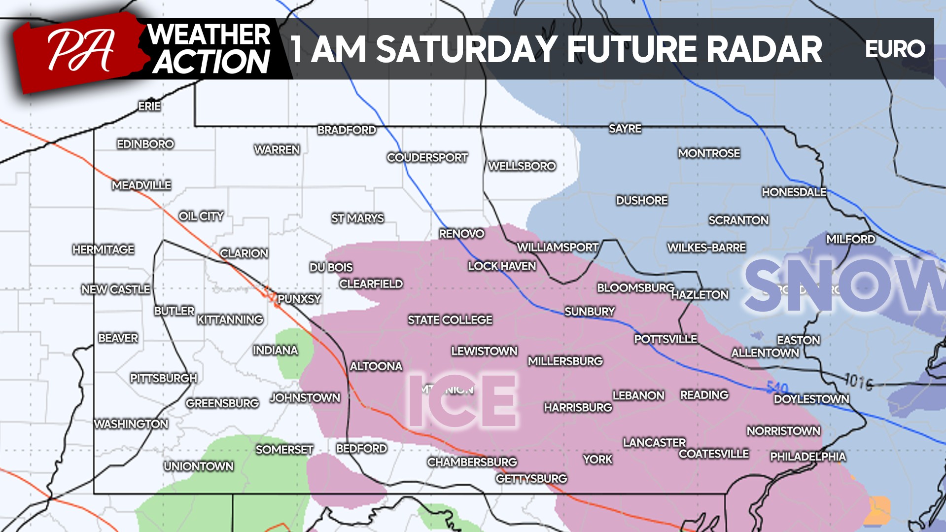
Temperatures will not get above freezing in the eastern half of PA Saturday, meaning slick conditions will persist on untreated surfaces.
FIRST CALL ICE ACCUMULATION FORECAST
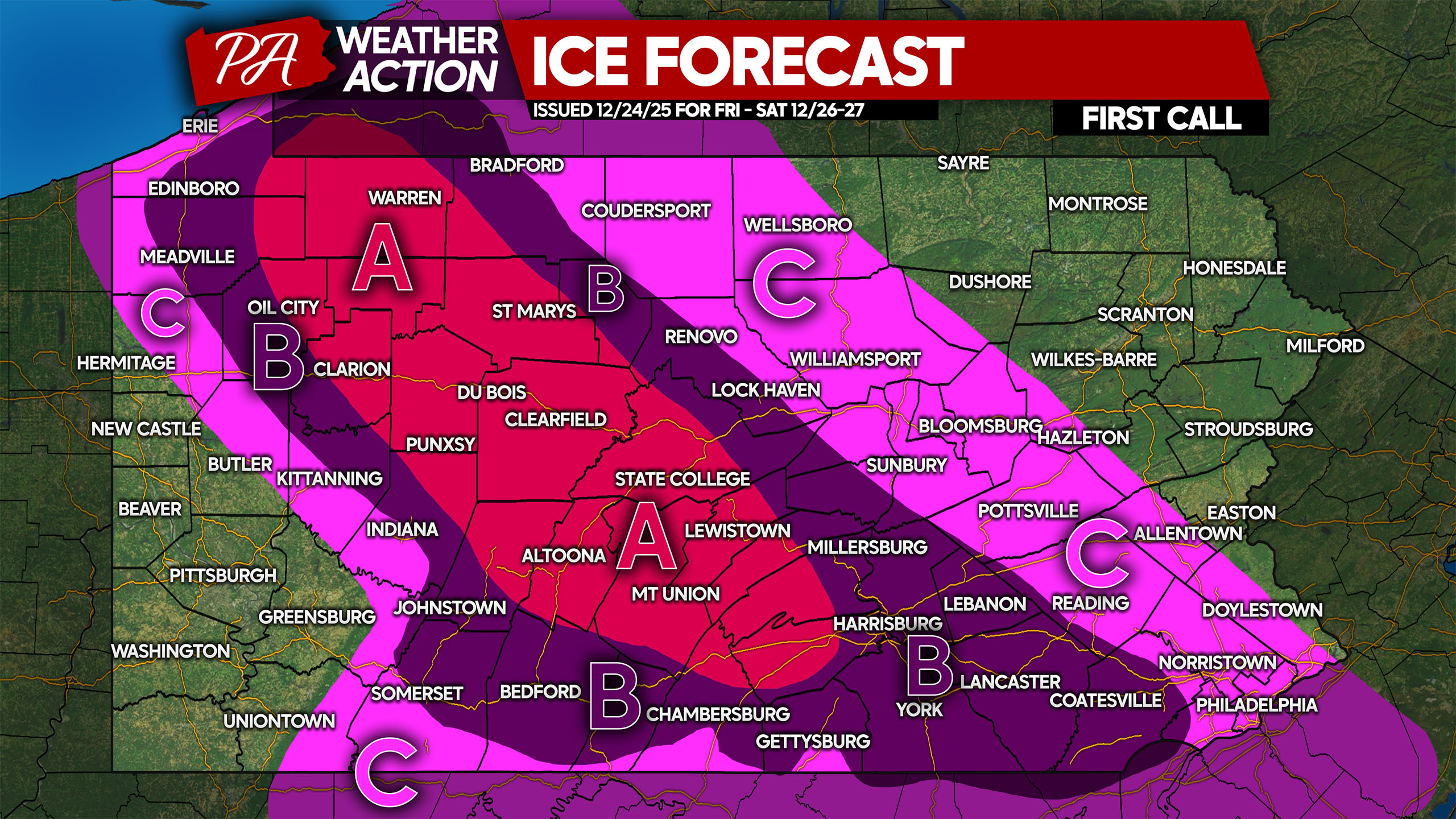
Area A: Ice accumulation of 0.25 – 0.35″ expected. Travel will be dangerous and should be avoided during and shortly after the storm. Walking outside should be done with caution to avoid falls. Isolated power outages are possible.
Area B: Ice accumulation of 0.10 – 0.25″ anticipated. Travel will be dangerous and should be avoided during and shortly after the storm. Be cautious when walking outside to avoid falls.
Area C: Ice accumulation of 0.05 – 0.10″ expected. Roads will be very slick and travel should be avoided while temperatures are under 32°.
FIRST CALL SNOWFALL FORECAST
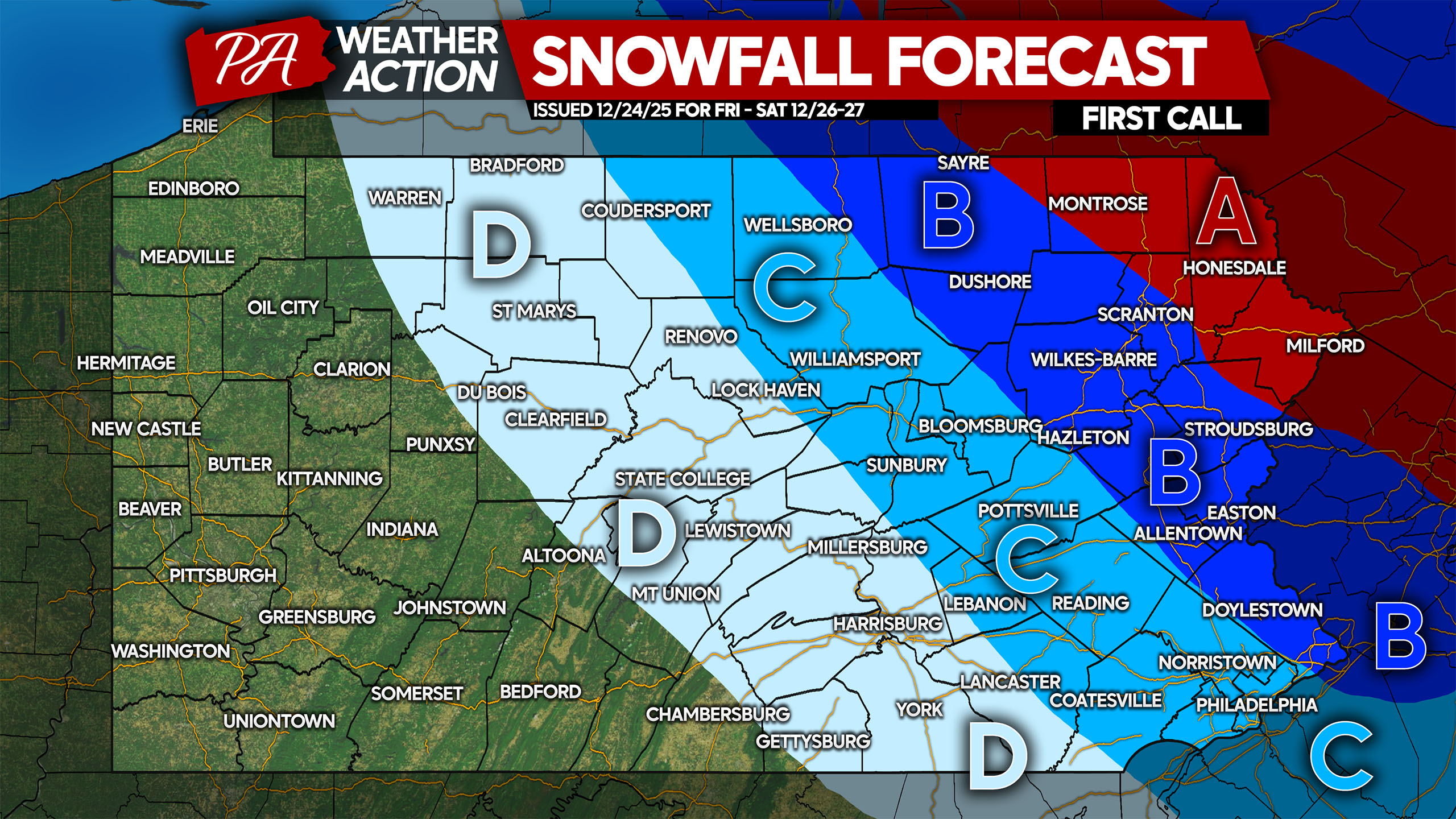
Area A: Snowfall accumulation of 6 – 10″ expected. Snow-covered roads will make travel very difficult and slippery. This area will see all snow.
Area B: Snowfall accumulation of 3 – 6″ anticipated. Snow-covered roads followed by sleet will make roads very treacherous. Avoid traveling during the storm.
Area C: Snow and sleet accumulation of 1 – 3″ expected. Roadways will be covered immediately with temperatures below freezing.
Area D: Sleet accumulation of up to 1″ expected, followed by freezing rain. Roads will be slushy and icy, avoid traveling.
Many people are traveling on Friday, so be sure to share this forecast with family and friends!
You must be logged in to post a comment.