After a rather warm day across PA Today, it is almost hard to believe in a couple days we will be dealing with a Winter Storm impacting us on Thursday.
As we mentioned yesterday, we are watching two areas of low pressure systems this week that will lead to our Winter Storm on Thursday. One will be dropping out of Canada in the form of a weak clipper system, while another area of low pressure develops in the south and eventually heads northeast. Where these two systems merge off the coast on Thursday, will determine how much snow we end up receiving. The quicker and further south these two systems merge, the more likely it is our state receives the higher end of our first call snowfall ranges.
If the low pressure systems do merge far enough south and strengthen rapidly off the coast of New Jersey, far Northeastern PA may receive higher totals than we are currently predicting. However, this is more of a “wild card” scenario, so we kept the higher totals out of the state, for now.
Unlike past storms, where it was plenty cold enough at the surface for snowfall, but many areas received sleet and freezing rain instead because of the upper levels in the atmosphere being too warm, this time around, just the opposite is expected for the southern third of PA. Although snow will fly in these areas, temperatures will likely be in the middle to upper 30s. In order for the snow that flies to accumulate, the snow would have to come down at a rapid rate. So we do expect the snow to melt while it falls for these areas.
Timing: Snowfall will develop in Western PA by the early morning hours on Thursday and will expand into the rest of PA by lunchtime. We should begin to clear out late Thursday Evening as this system is a quick hitter.
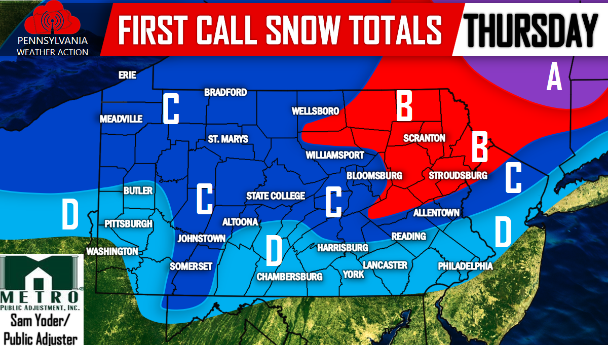
FIRST CALL SNOW MAP FOR THURSDAY 12/29
Area A: 4 to 6 inches of snowfall is expected. This area would be expanded into far Northeast PA if the “wild card” scenario played out.
Area B: 2 to 4 inches of snowfall is expected.
Area C: 1 to 2 inches of snowfall is expected. Surface temperatures will be right around the freezing mark, perhaps just above, so this area will need heavier snowfall rates for the snow to accumulate.
Area D: A coating to 1 inch of snowfall is expected. Because temperatures are expected to be above freezing, the snowfall will have a tough time accumulating, therefore less than an inch of snow is expected.
For further updates regarding this upcoming storm and much more, be sure to have our page liked on Facebook, click here>>>PA Weather Action on Facebook!
We will have our second call issued Tomorrow Evening at 5 PM. Be sure to share the news with your family and friends below!


You must be logged in to post a comment.