
FINAL CALL POSTED:
Final Call Snowfall Forecast for Wednesday’s Elevation-Dependent Snow
After a few days with temperatures in the 60s and 70s, the last thing you expected to be reading about today was snow – in just two days from now. A strong cold front accompanied by a line of severe thunderstorms with potentially damaging winds is making its way east this evening, with much colder temperatures behind it. On Tuesday, temperatures will be around average. And by Wednesday morning, we may very well be looking at heavy snow in parts of the state.
With marginal temperatures in the low to mid 30s during the onset of precipitation Wednesday morning and a warm ground, it will take heavy snow rates to cause accumulation even on unpaved surfaces. That is exactly what is expected for a period Wednesday morning, as a low pressure to our SW moves in, causing a thump of warm air advection snow. The two most important factors are when the snow starts and how fast it falls. If the snow starts in your area before sunrise, there are better chances of decent accumulation because it won’t be battling the sun angle as much. This is why highest snowfall accumulations are expected in South Central PA, where snow will begin first and fall heaviest.
TIMING
Moderate snow will push northeast in South Central PA in the pre-dawn hours of Wednesday, between 3-5 AM. The snow will then expand northeast into most of Central and Eastern PA by mid to late Wednesday morning. It will continue northeast and exit the area from southwest to northeast in the late afternoon to early evening. View the future radar below for a better idea of timing in your area.
FIRST CALL SNOWFALL FORECAST FOR WEDNESDAY
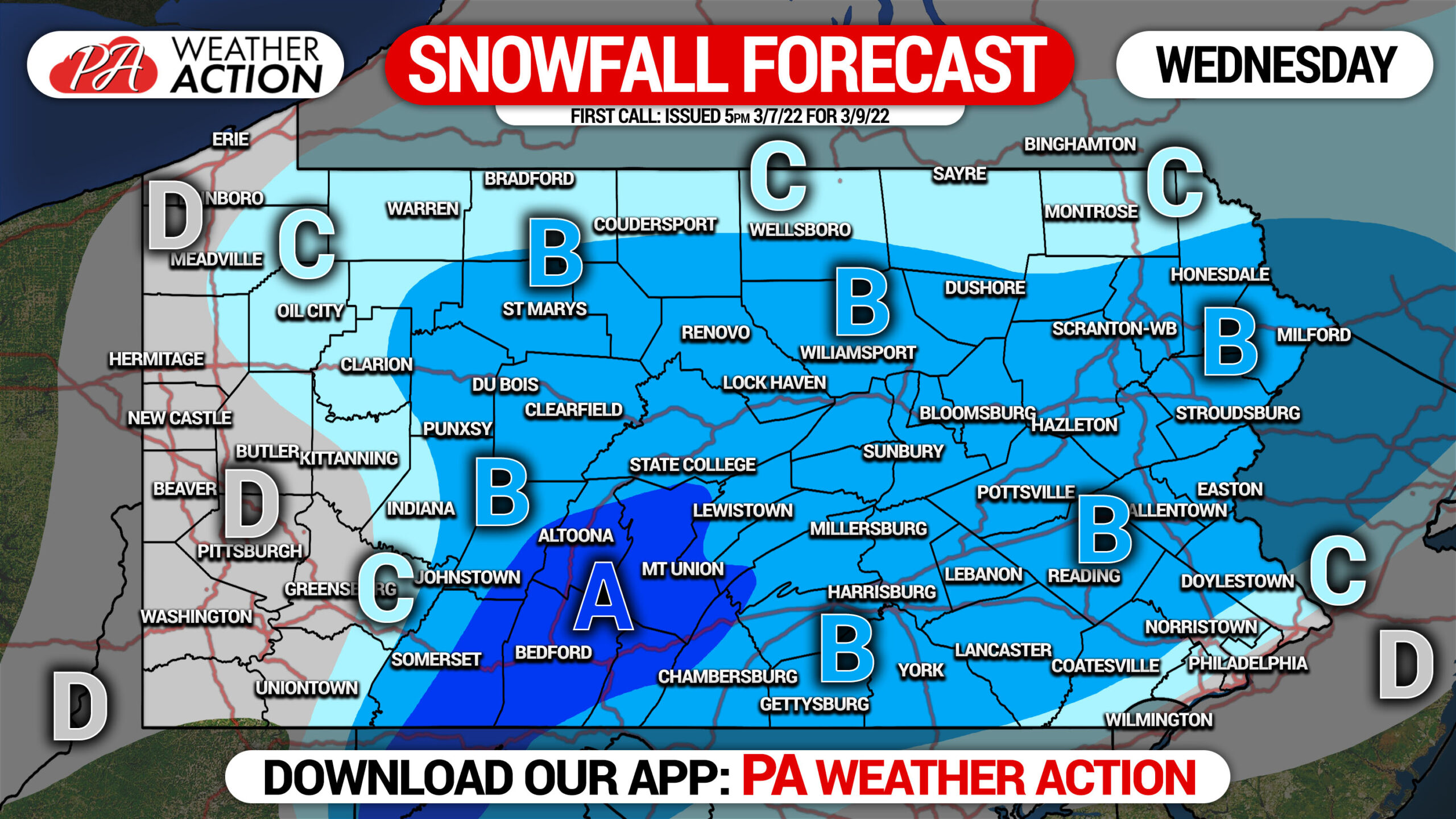
Elevation will play a role in this event. If you’re on a ridgetop, expect totals at the higher end of the range. If you’re in a valley, expected totals at the lower end of the range.
Area A: Snowfall accumulation of 3 – 4″ on unpaved surfaces, 1 – 2″ on untreated paved surfaces.
Area B: Snowfall accumulation of 2 – 3″ on unpaved surfaces, coating to 1″ on untreated paved surfaces.
Area C: Snowfall accumulation of 1 – 2″ on unpaved surfaces, coating on untreated paved surfaces.
Area D: Snowfall accumulation of less than 1″ on unpaved surfaces.
Be sure to return back for our final call on Tuesday evening, as models aren’t locked in yet. The trend lately has been for more amplification, meaning snow farther north. This forecast was made with some expectation of that trend continuing.
Don’t forget to share this surprise snowfall forecast with family and friends below! Stay safe!
[social_warfare]
Get our latest forecasts, 11 map layers, road conditions and more with our app! Tap the icon below to download it.

You must be logged in to post a comment.