Two separate winter weather events are likely in the coming days, before temperatures drop Friday (Dec 9th). There is a good chance that a winter storm with widespread impacts will take place sometime between December 9th and December 17th. However as mentioned we have two events incoming just in the next several days.
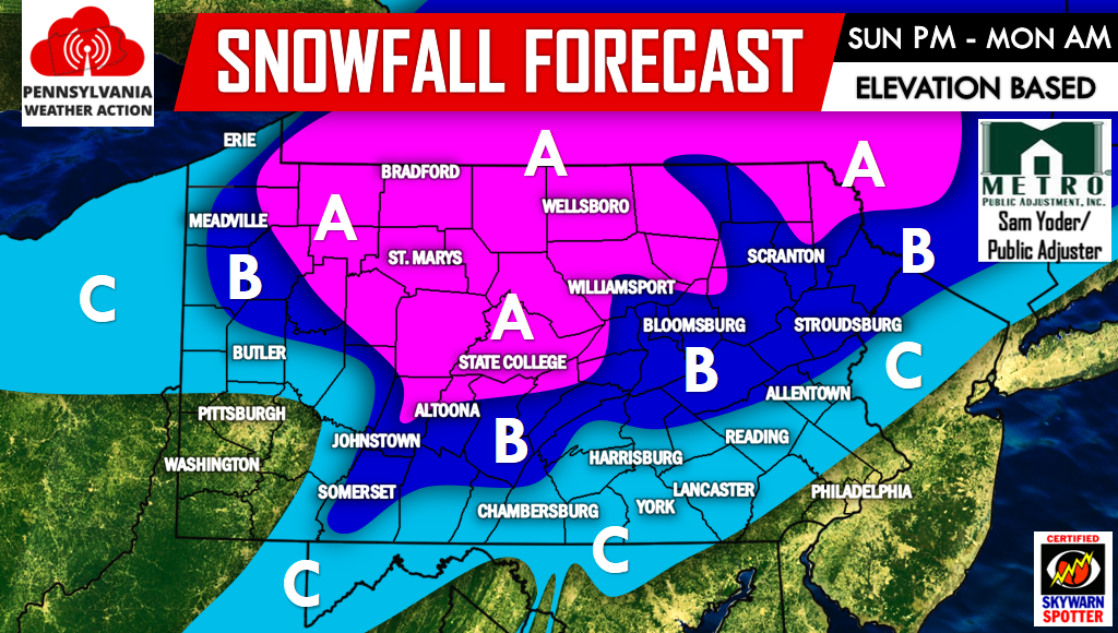
The first event arrives Sunday Evening, leaving Monday Morning. A clipper-like system will move through the region resulting in light rain and snow.
SUNDAY PM – MONDAY AM CLIPPER MAP FORECAST
Area A: Light snow will move in Sunday Evening from west to east, exiting from west to east as well Monday Morning. About 1-2″ of snowfall accumulation expected, with up to 3″ above 2,000′ elevation. If not salted, roadways may be snow coated or covered.
Area B: Light rain at the onset of precipitation will Sunday Evening will change to snow after 10 PM, lasting through Monday Morning when snowfall will move out from west to east. A coating to an inch of snowfall accumulation is expected with scattered amounts of up to 2″ above 2,000′ elevation.
Area C: Light rain at the onset of precipitation will lead to a change-over to snow late Sunday Evening into Early Monday Morning before changing back over to rain. A coating of snowfall is possible but will be melted by rainfall. Areas above 1,800′ may receive up to an inch of snowfall.
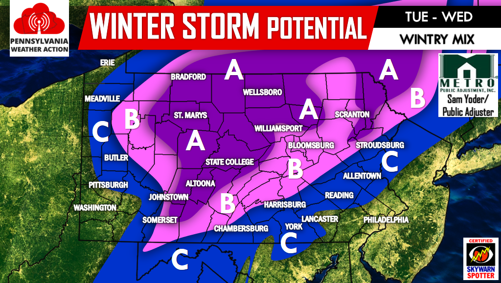
The second event arrives Tuesday, lasting into Wednesday. Here is the current prediction for that event.
TUESDAY – WEDNESDAY WINTRY MIX MAP FORECAST
Area A: Snow will move in Tuesday Evening, continuing through the night and into Wednesday Morning. A change-over to rain is possible at the end of the event Wednesday Afternoon. However by then only light precipitation will remain. Moderate snowfall accumulation possible.
Area B: Snow will move in Tuesday Evening, lasting into the pre-dawn hours of Wednesday before changing over to rain. Light to moderate snowfall accumulation possible.
Area C: Precipitation will enter the area Tuesday Evening likely as snow. Snow will persist for several hours before changing over to rain a few hours before sunrise Wednesday. Light snowfall accumulation possible.
Confidence is higher for the event Sunday Evening into Monday Morning as you would expect. As mentioned, the next two weeks will be very active weather-wise so be sure to have Pennsylvania Weather Action liked on facebook by clicking. Also be sure to share this forecast below with your friends and family. Stay safe!


You must be logged in to post a comment.