
THIS FORECAST HAS BEEN UPDATED. CLICK HERE FOR WEDNESDAY’S UPDATE.
-Pennsylvania Weather Action Lead Forecaster Josh Adams
We are currently tracking our first potential Winter Storm of the season, that will arrive late Saturday Evening and will last through Sunday. The potential storm system is roughly 100 hours away from impact and there is big time disagreement with our current guidance.
Breakdown: A low pressure system will be cutting through the Great Lakes region late this week and will have a trailing cold front along with it. The cold front is our main focus. As we head into the day Saturday, the cold front will cross the state from West to East. The cold front will bring with it rain showers to start, but these rain showers will change to snow showers as temperatures will rapidly drop.
GFS projected high temps for Saturday valid 2 PM: 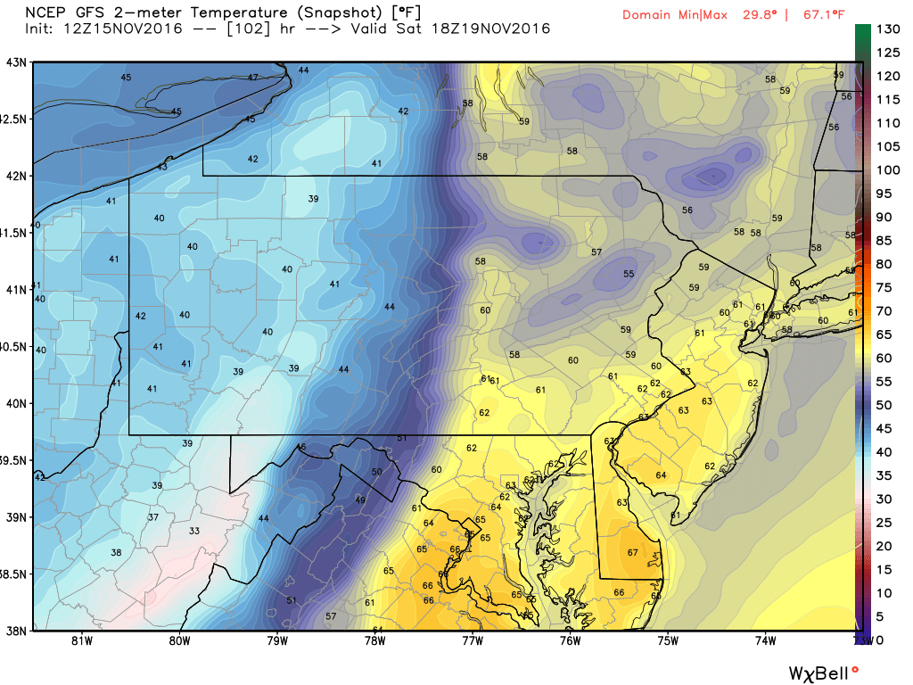
You can clearly see the cold front splitting PA in half. And yes, it’s possible for areas to be in the upper 50s, to even 60s in the afternoon Saturday and have snow falling by late Saturday Night into Early Sunday Morning.
We will skip to next frame here valid 8 PM Saturday Evening after the Cold Front has passed through: 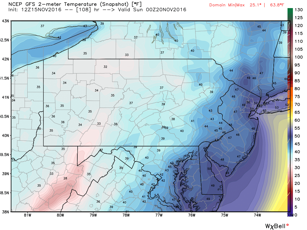
15 to 30 degree temperature drop across Eastern PA. More importantly, the Western half of PA stayed relatively cold in both images, leading to increased odds of receiving some accumulating snowfall.
The major difference between the models right now is whether a coastal storm forms off the Jersey Coast as the front approaches the coastline. The Euro and Canadian develop this rapidly, especially the Euro, which helps produce a significant snowfall for much of the state Saturday Night into Sunday. The GFS on the other hand, is much less aggressive and does not develop the coastal low until it is well North of our area, resulting in wraparound lake effect snows for the Western part of the state, but nothing significant.
How much snow are the models printing out? GFS, is the least aggressive with a couple inches of snowfall for the Northwest part of the State. The Canadian model is the middle ground right now, with a widespread 3-6″+ snowfall, with the exception of Southeastern PA. The European, the most aggressive model, has a widespread 8-12″+ for Central and Western areas of PA. While Eastern PA only receives upwards of an inch or two.
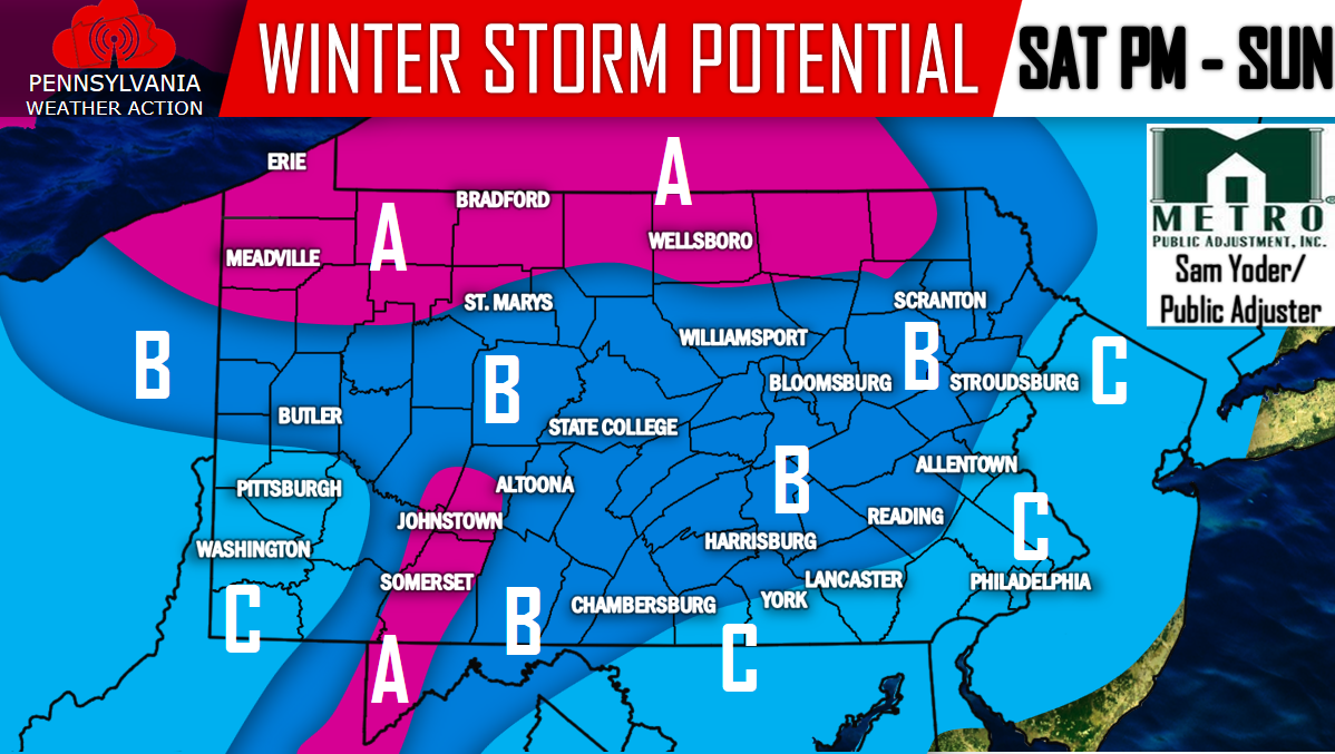
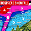
The European Model seems a little too aggressive in our opinion, but it is not impossible. Taking a blend of all three models we come up with this map below: No amounts just yet, we will wait until we are within 3 days before we start forecasting numbers.
Again the timing of this system looks be Saturday Evening through Sunday.
Because of the major differences in the model guidance it is important to make sure you have us “liked” on Facebook for the latest by clicking here>>>PA Weather Action on Facebook!
**All areas will begin as rain before changing to snow.**
Area A: Regardless of whether a coastal low develops or not, this area has the best chance of receiving accumulating snowfall. Whether it be a coating, or more than 10 inches, it is too early to tell.
Area B: Accumulating snowfall is possible in this area. Depending how fast temperatures drop after the cold front passes through, will be a big determining factor whether the snow will have the opportunity to stick. However, if it snows hard enough, temperatures won’t be an issue. Again, too early to tell exact totals, if any.
Area C: Some snowfall is possible, but likely will not accumulate.
Don’t forget to hit that share button below to inform family and friends about the potential for our first Winter Storm of the season! Stay tuned to PA Weather Action!
You must be logged in to post a comment.