
By now you have probably heard about a big winter storm that is possible for this weekend. While the rumor is true, we have a storm threat to track for Thursday evening into Friday morning first. This first system will have major implications on what happens down the road with the weekend storm. We will explain shortly. Regardless of the outcome with the weekend storm, a severe arctic outbreak is more than likely to impact the area next week with more opportunity for winter storms.
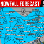
The first storm we are tracking Thursday evening into Friday will most likely bring a period of light to moderate snow for most locations. Currently it appears most areas will see 1-3/2-4 inches of snow from this system with the possible exceptions being far Southwestern and far Southeastern PA. Below is look at the latest GFS run valid for 1:00 AM Friday morning: 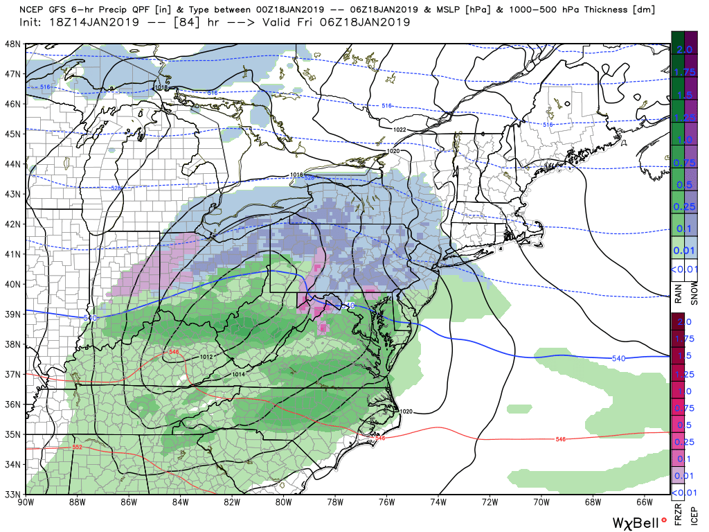
The snowfall amounts from system one is not what we are most interested in. We are most interested in how strong or how weak this storm system will be. The stronger the first storm is, the more it allows for heights over the East Coast to lower which will lead to a snowier solution for just about everyone. If the first storm ends up being weaker, the higher the heights over the East Coast will be, which will allow for a warmer, wintry mix/rain solution over a snowy one.
We are still about 5 days away from any potential storm impacts from this weekend’s storm so we will not discuss any specific details. We can say we are confident there will be a significant storm no matter what the precipitation will be. Below is a look at the three general possible storm tracks for this weekend’s storm: It is important to note right now, we are not favoring one track over the other. 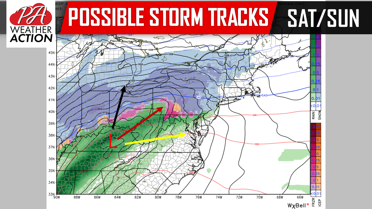
Black track: This would be the likely track if the first storm completely flattens and becomes very weak. This would lead to a mainly rain storm for just about everyone in Pennsylvania.
Red track: This is the middle ground track as of right now. This particular track allows for most areas to begin off as period of snow, with areas north of I-80 hanging onto snow the longest. However, as the low pressure moves in closer to the state, it will bring with it warmer air, allowing for everyone south of I-80 to change over to rain. The areas that do receive all snow out of this scenario would receive heavy snow totals. It is also possible that as the storm pushes off to the northeast, areas that change over to rain in this scenario could change back over to snow. Which currently the GFS model shows this solution.
Yellow track: If you love the snow, this is track you want to be rooting for. If our first storm on Thursday evening/Friday can trend more robust and stronger, this will allow for heights to lower on the East Coast bringing the track for our weekend storm south of the state. The result of this track would lead to a major snowstorm for just about everyone in Pennsylvania, with the greatest totals over the southern half of the state. It is very rare for the whole state to receive a major snowfall in one storm, but this would be the storm to deliver such a snowfall for such a large area if this track comes to fruition.
What is a certainty, is behind this weekend’s storm system, true arctic air will pour into the region. Temperatures will range from 10 to 20 degrees colder than normal for an extended period of time during the second half of January. Take a look at the project HIGH temperatures for next Monday: 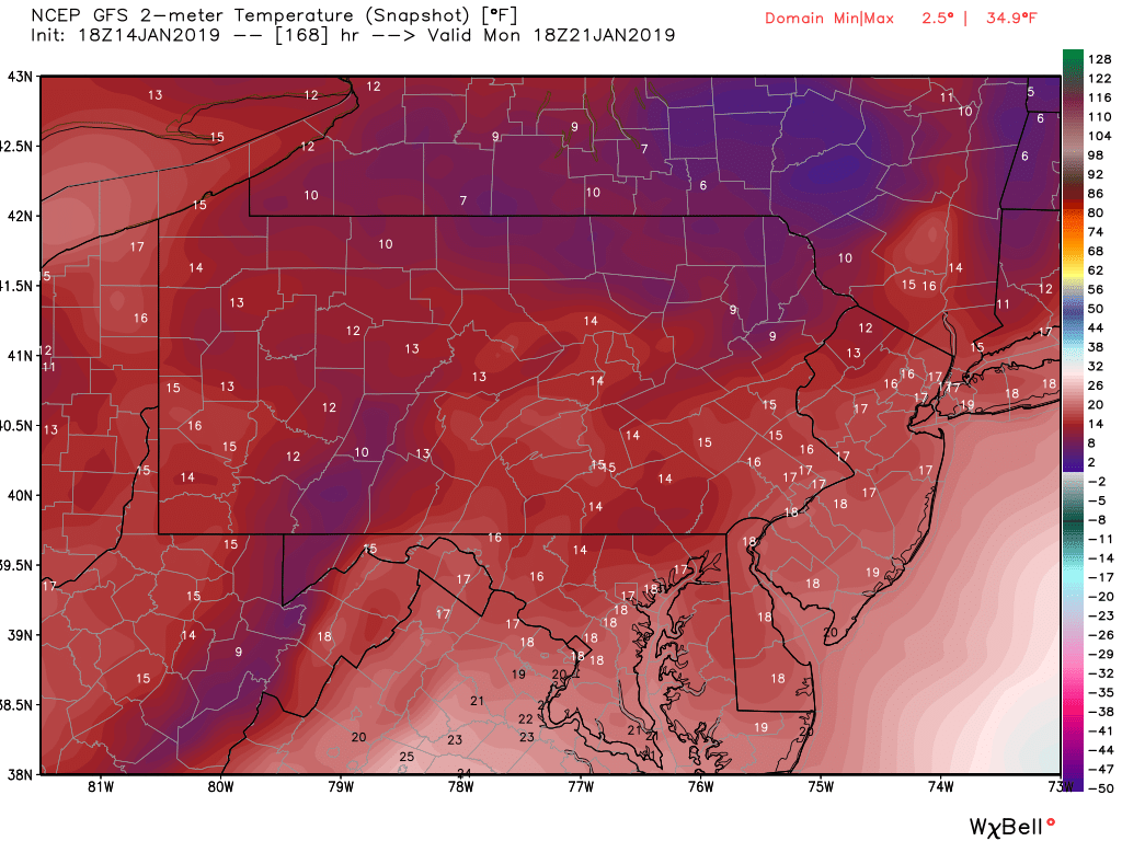
High temperatures in the low to middle teens with wind chills values even colder in the middle of your Monday afternoon. Factoring in the all the cold air that will be in place by next week, another potential storm is brewing around the middle to end of next week. But we have to get through these first two before we discuss that storm. Long story short, for those that were disappointed in the lack of winter storms this year, you are getting your wish. It will be a very active pattern for at least the next several weeks.
Stay tuned to our Facebook page tomorrow evening for a first call on Thursday evening/Friday morning’s snowfall, as well as our first potential impact scenarios map regarding this weekend’s storm. Click here to like our Facebook page: Pennsylvania Weather Action’s Facebook Page
Download our free app today to keep you ahead for the latest weather alerts and traffic conditions, click here: Pennsylvania Weather Action’s App
Share our article with your family and friends using our icon below!
You must be logged in to post a comment.