
Whether you are ready or not, winter is knocking on the door! In today’s article we will dive into the full details regarding this upcoming winter. We will discuss the science and data that backs up our forecast throughout the article, as well as the month-by-month breakdown and snowfall forecast.
TECHNICAL DISCUSSION
As with every winter forecast, the main driving factor is the the state of the ENSO region in the Equatorial Pacific Ocean. In this region, we take a look at the sea surface temperatures. If the sea surface temperatures are warmer than average, we are likely to experience an El Nino pattern. If sea surface temperatures in this region are colder than average, than we can expect a La Nina pattern. It is important to determine which state of the ENSO we are currently in because this drives our overall pattern. When taking a look at our current sea surface temperatures across the Equatorial Pacific Ocean, you can see we are in a neutral phase. 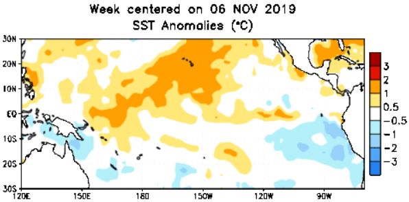
During an average neutral phase ENSO winter, an active sub-tropical jet stream is common with multiple cold shots from Canada. The combination is exactly what you want to see if you are a snow lover. Now this does not mean every storm will produce snow for the area, however an increased likeliness of all snow events versus mixed events is increased for this upcoming winter, especially for January through March.
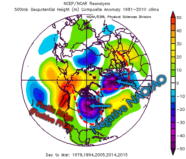
Looking at analog years at the 500mb level, we notice a few key factors. Ridging over the Gulf of Alaska and across the west coast due to a positive PNA will help promote several cold shots to our area throughout the winter season. Our analogs are also pointing towards a negative AO, indicated by the colder colors over eastern North America above. This is another factor that promotes cold shots into our area. The third thing is the negative NAO. With a negative NAO, this typically allows for our overall pattern to slow down. This could result in larger storms to form, especially during the middle of the winter.
In addition, the combination of above average snowfall in from Siberia to Canada and a neutral QBO will generate favorable conditions for a weak polar vortex. This means instead of all the Arctic cold being bottled up in the Arctic regions, it may spill down south into our region from time to time.
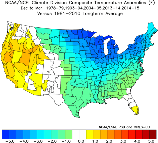
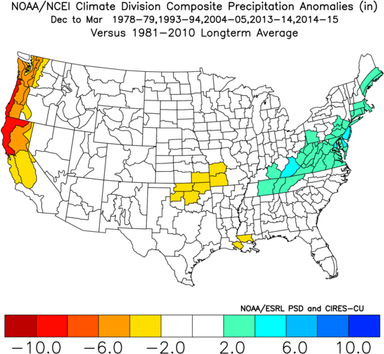
It is quite evident that during our analog years, temperatures were quite cold compared to average. This makes sense given the previous upper air pattern setup at the 500mb level. Next we take a look at the precipitation for those same years. Overall, average precipitation was experienced across the northern half of the state, while the southern half experienced slightly more precipitation than normal. Now remember this map below includes all precipitation, not just snow.
With all research being considered, it’s time for our winter forecast for Pennsylvania. First, we give you a month by month breakdown, followed by our temperature and snowfall map.
MONTH BY MONTH BREAKDOWN
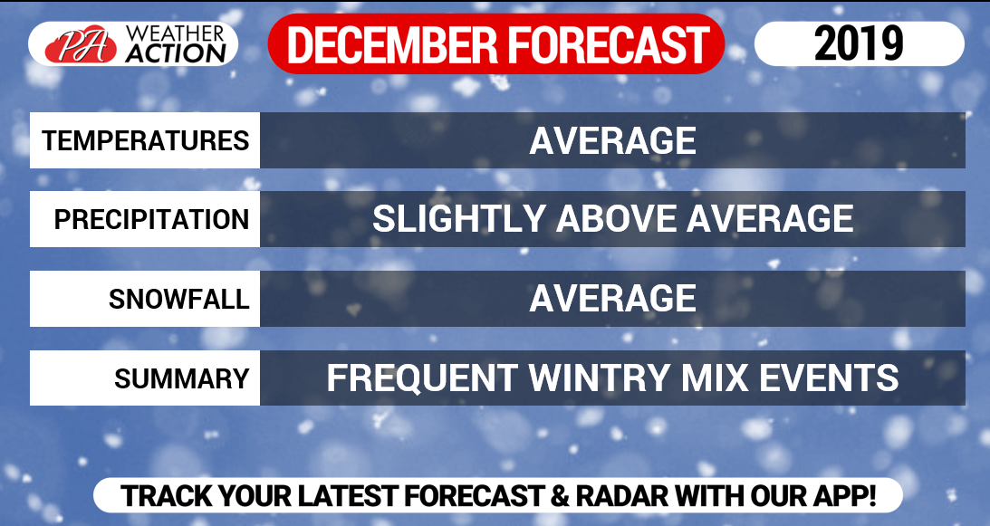
DECEMBER FORECAST
Unlike previous Decembers when we experienced well above average temperatures and below average snowfall, we expect this December to be much more seasonal. It will still be treated as a transition month into our winter. Not all winter storms we see in December will be pure snowstorms. We do expect several wintry mix events, however snowfall amounts should be around average for most of us. A white Christmas is more likely than the past couple Decembers.
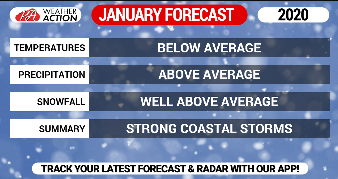
JANUARY FORECAST
We expect January to be the harshest of the winter months. Temperatures will be below average with well above average snowfall. There will be an increased likelihood of strong coastal storms during this month. These storms usually favor eastern areas, however we still anticipate numerous clippers and lake effect snowfall that will lead to the majority of the state receiving well above average snowfall.
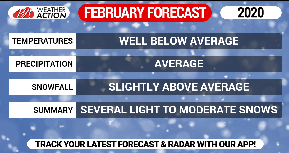
FEBRUARY FORECAST
February will be the coldest month with temperatures well below average. Many of the cold shots during this month will be accompanied by clipper sytems. Clippers typically drop light to moderate snowfall. Because of the frequency of the clippers and the potential for coastal storms (although not as high as January), we do expect to see slightly above average snow. Temperatures will favor all snow events during this month, unlike previous winters where many of our winter storms featured all forms of precipitation.
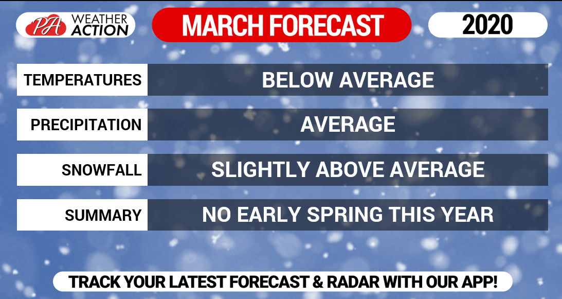
MARCH FORECAST
Last winter, the season ended early. March did not produce much in the way of winter weather. We expect the opposite this year. Below average temperatures are expected with slightly above average snowfall. It will take until the last week of March and maybe even the first week of April before we start to experience Spring-like weather.
WINTER 2019 – 2020 SNOWFALL FORECAST
With more coastal storms anticipated this season, along with below average temperatures likely, especially to begin 2020, we predict about 50% more snowfall than average for much of southern and eastern PA. In northern and western PA, near average lake-effect snow is expected. Also, these areas typically see less snow from coastal storms and can be too far north as well when storms are suppressed south. As a result, we predict about 10% more snow than average in northwest PA.
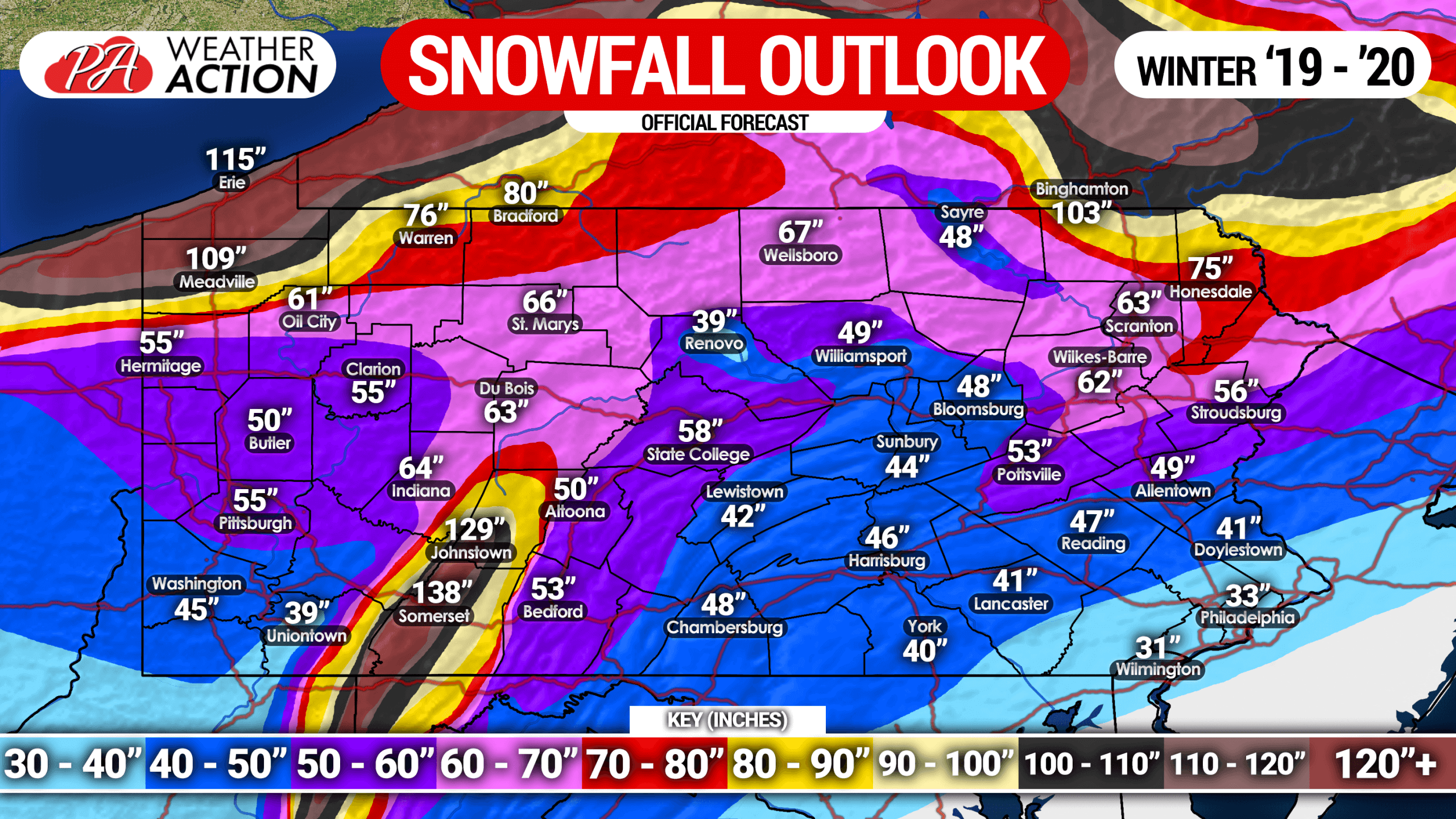
As you can tell, snowfall across the state is very elevation-dependent, and there are also some locations that average much more/less than surrounding areas. Overall, a snowier winter than usual is projected for the entire state, but especially the eastern half of Pennsylvania.
This is one of those unusual years when nearly everything is favorable for a cold and snowy winter. Sure, teleconnections could become unfavorable during the season for multiple weeks, but that is a variable every year. This will be a humbling year for forecasters/meteorologists if the winter doesn’t produce the previously stated outcome, and many will be very cautious to forecast a cold and snowy winter in the future if this winter doesn’t work out.
Thanks for reading everyone, and be sure to stay with us throughout the winter!
Don’t forget to share this winter forecast with your friends & family using the button below!
For all our winter weather updates this season, plus your local forecast and radar, download our free app! >>> Weather Action App
We do morning videos, going over latest model trends and more ahead of winter storms. Subscribe to us on YouTube >>> YouTube Channel
You must be logged in to post a comment.