
Gusty winds will take hold the next few days as cold air floods in. The start of meteorological winter will almost perfect align with the start of actual winter this year, with colder than normal temperatures expected for the next several weeks.
Here is a look at wind chills taking a nose dive Wednesday evening, only topping out in the 20s and low 30s on Thanksgiving and teen and 20s on Black Friday.
As these strong westerly winds blow over the Great Lakes, they’ll lead to the first significant to major lake effect snowstorm of the season. We expect December to be pretty active with frequent cold fronts pushing through!
Below is a loop of the Hi-Res NAM Future Radar for the duration of this event. Lake effect bands will produce snowfall rates of 1-2″ per hour, with banding focused in Northwest PA on Thanksgiving.
By Friday morning, we will begin to see snow bands making their way farther from the lakes. Even Scranton could see a similar situation as a few weeks ago with some lake effect bands potentially creating slick travel parts of Friday.
FINAL CALL SNOWFALL FORECAST FOR HOLIDAY LAKE EFFECT SNOW IN PA
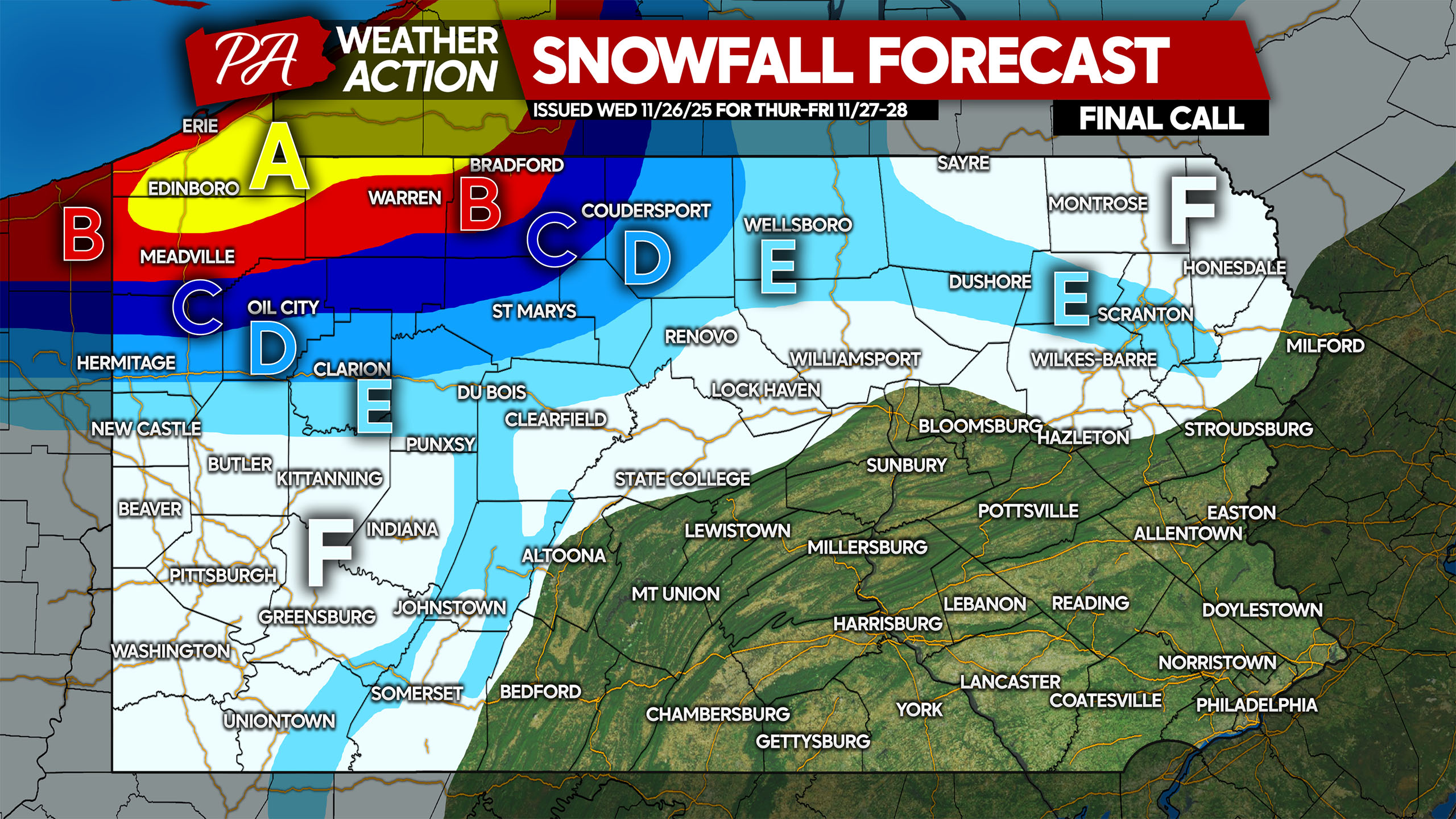
Area A: Snowfall accumulation of 12 – 18″ expected. Most roads will be snow-covered Thanksgiving into Black Friday.
Area B: Snowfall accumulation of 8 – 12″ anticipated. Snow-covered roads will lead to hazardous travel.
Area C: Snowfall accumulation of 5 – 8″ expected. Snow-covered roads likely during and after snow squalls.
Area D: Snowfall accumulation of 3 – 5″ anticipated. Roads will become snow-covered during and briefly after snow squalls.
Area E: Snowfall accumulation of 1-3″ expected. Roads will be mostly clear except during and briefly after snow squalls.
Area F: Snowfall accumulation of less than 1″ anticipated. Roads should stay clear.
Don’t forget to share this forecast with family and friends who may be heading out or traveling through impacted areas!
You must be logged in to post a comment.