


Unfortunately, a very serious and catastrophic situation is unfolding right in front of us as Hurricane Irma approaches closer and closer to the United States. Hurricane Irma is currently a category five. Only three hurricanes in United States history have made landfall as a category five in the United States. Irma has the potential to be the fourth. Not only that, it is very possible Irma ends up being the most expensive storm in history due to the path it is projected to take.
Below is the National Hurricane Center’s 5:00 PM advisory:
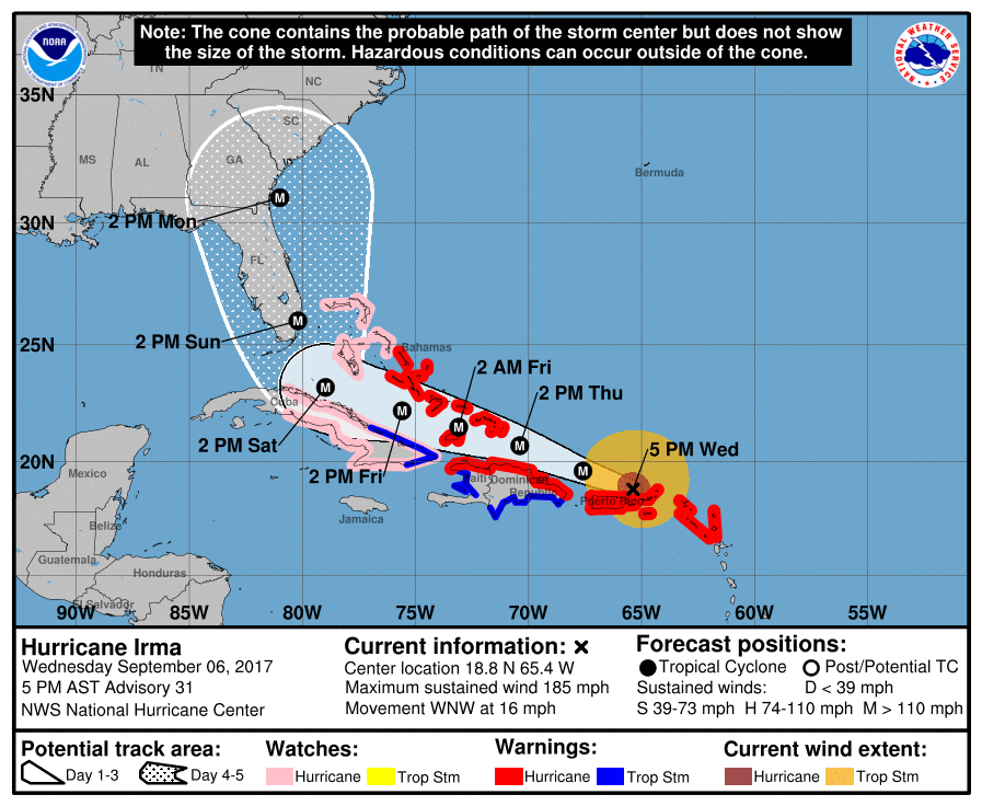
Irma is expected to make landfall near Miami by Sunday Morning. It is anticipated that cities and beaches such as Miami, Fort Lauderdale, Palm Beach, Vero Beach, Melbourne, Orlando, Daytona Beach, Jacksonville, and Savannah all will experience major to catastrophic damage from intense winds sustained over 140 MPH, with gusts even higher. Major storm surge is expected as well, whatever is not damaged by the wind, will be damaged by the flooding.
Because we are still four days away, there is still some guidance disagreement regarding the exact path Irma takes. To show this, below is the GFS ensemble guidance:
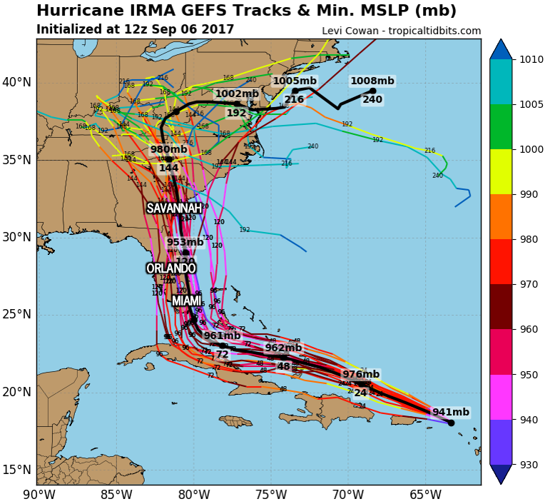
Regardless of what path Irma takes, the eastern coast of Florida is in serious trouble. If you live in Florida, or know any family or friends that live in Florida, it is HIGHLY recommended you evacuate.
Florida will not be the only state impacted by Irma. Areas close to the Georgia and South Carolina coast will also potentially experience major to catastrophic damage as Irma will most likely make a second landfall somewhere along the GA or SC coast.
We have been receiving tons of questions regarding our thoughts on Irma, while we are still too early to give a specific forecast, we decided to break down Hurricane Irma’s impacts with three scenario maps, each having a percentage along with it.
HURRICANE IRMA SCENARIO MAPS
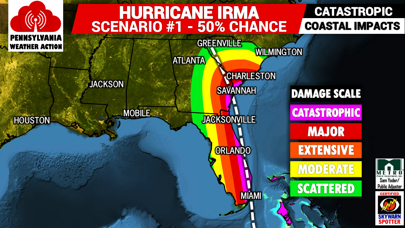
Scenario #1 – 50% Chance: This is the worst scenario for Florida, and unfortunately is most likely. If this scenario occurs, Hurricane Irma will make landfall near Miami as a strong category four or weak category five. Catastrophic damage will occur along Florida’s entire east coast. The Georgia and lower South Carolina Coast will also see catastrophic damage with this scenario. Hurricane force winds will be felt inland, with Orlando and surrounding areas seeing extensive to major damage.
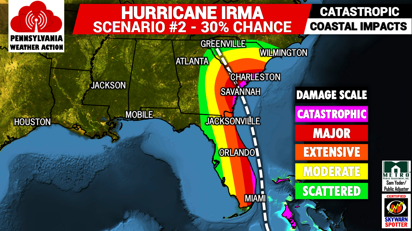
Scenario #2 – 30% Chance: This scenario brings Hurricane Irma east of Florida, with a landfall near the Georgia/South Carolina border. If this scenario plays out, catastrophic damage will be felt in Miami, Savannah, and Charleston. Locations such as Melbourne, Daytona Beach, and Jacksonville will see extensive to major damage. However, Western Florida will be spared if this happens and will only see scattered damage.
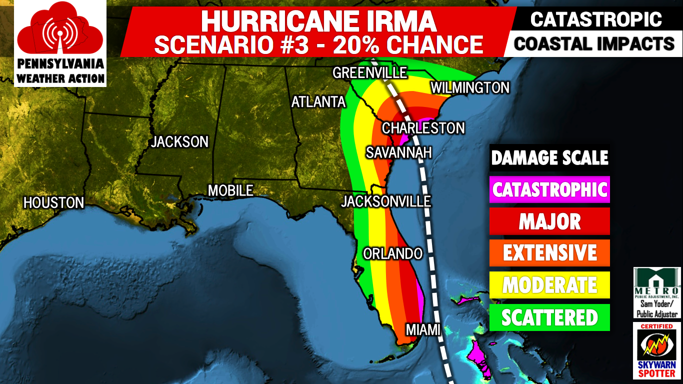
Scenario #3 – 20% Chance: This scenario is the best for Florida, and worst for South Carolina. If scenario three materializes, Hurricane Irma will stay far enough away from the coast of Florida, only to give beaches north of Miami catastrophic damage. The rest of Florida’s East Coast will see extensive to major damage. Charleston will see catastrophic damage as Irma makes landfall just south of the city. Inland Florida will see moderate damage, while Western Florida comes away with little damage.
What will we see here in Pennsylvania? We may see some moderate rain mid next week, but no big impacts.
Be sure to have us liked on facebook to stay updated on Irma and much more as we head into winter >>> Like PA Weather Action on facebook. If you have friends and/or family in the Southeast, remember to share this with them. You can also download our app by searching “PA Weather” on Apple and Android.
You must be logged in to post a comment.