FIRST CALL SNOWFALL FORECAST POSTED:
The first widespread winter storm threat of the season is upon us, with the well-advertised cold and potentially stormy December starting with a bang. We are monitoring a winter storm that will begin Tuesday morning, ending early Wednesday morning. Pennsylvania is a large state, and we will have more precise timing info as we near the storm.
This storm will be on the fringes of a pattern change in very early December, when places like Southeast PA average nearly 50° as a high. Temperatures will be much colder of course, making this winter storm possible. However, climatology will still play a role and interior locations in the Appalachians are more likely to see significant snow as opposed to Philadelphia.
Climatology will be on display with this one, with moderate to potentially significant snowfall favored in northwest of I-95. The ceiling for this storm will be higher if the energy is more amplified, at the expense of Southern PA seeing more freezing rain/sleet than snow.
The battle on the weather models right now is where the low pressure will track. The following scenarios will break that battle down and what it will look across Pennsylvania with each setup.
SCENARIO MAP #2: 40% CHANCE
Scenario #2 represents the American (GFS) model, and some of the ensemble guidance (ensembles are models with slightly different calculations than the main operation model). This scenario will occur if the storm gets going sooner in the Southeast US.
If so, the system will be stronger and move into West Virginia before transferring to the Delmarva and pushing northeast. This is closer in proximity to us, and you usually want to be at least a hundred miles north of a low pressure center in the winter to see snow.
As a result, Southeast PA would see more rain, while Northern and Western PA would see a significant snowstorm.

Area A: Significant snowfall accumulation possible in the northeast quarter of Pennsylvania. Closures and disruptions to schools and businesses would occur in this scenario.
Area B: Moderate snowfall accumulation possible, with closures and disruptions to schools and businesses very probable in this scenario.
Area C: Light snowfall accumulation possible. Given the nature of Northwest PA, very little disruption would occur to daily life.
Area D: A wintry mix of snow, sleet, freezing rain (ice), and plain rain would occur in this scenario. Closures and disruptions to schools and businesses would be probable.
Area E: Just a plain, cold rain would occur with this scenario.
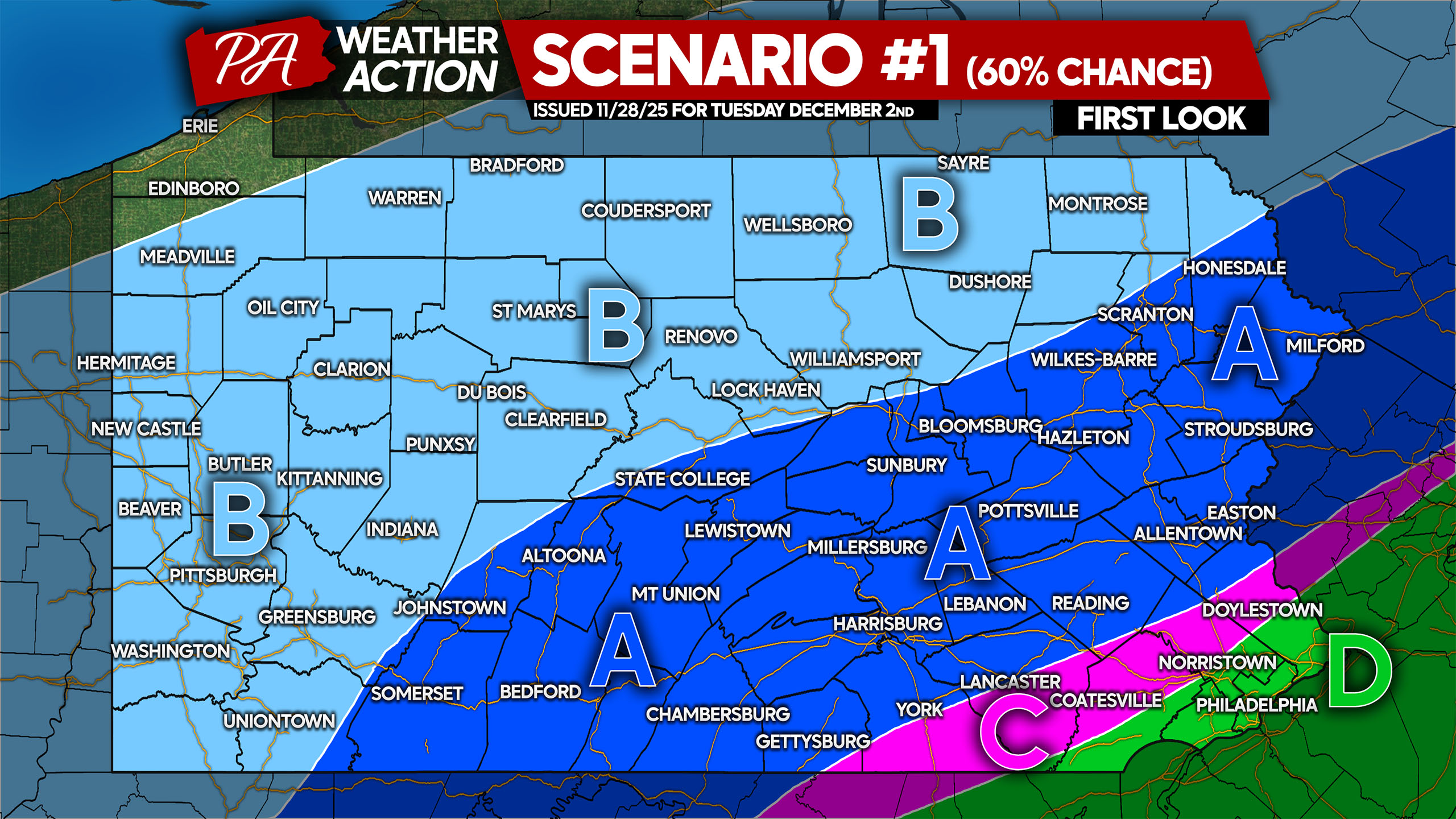
SCENARIO MAP #1: 60% CHANCE
This scenario represents a greater and more accurate set of models, making it more probable than the prior. The European model develops the system later on, and keeps it well off the Delmarva. This makes way for more cold air, putting more of Southern PA in play for moderate snow.
The ceiling with this scenario is lower, because it’s a slightly weaker storm at our latitude with less precipitation (as it’s farther away). Northern PA would see less snow, and the wintry mix area would be slightly southeast. Even still, there doesn’t look to be a scenario that’ll bring the Philadelphia area a winter storm.

Area A: Moderate snowfall accumulation possible, with closures and disruptions to schools and businesses likely in this scenario.
Area B: Light snowfall accumulation possible, with some disruptions possible.
Area C: A wintry mix of snow, sleet, freezing rain (ice), and plain rain would occur in this scenario. Closures and disruptions to schools and businesses would be probable.
Area D: Just a plain, cold rain would occur with this scenario.
That’s where things stand as of Friday evening for this potential winter storm on Tuesday. We will have our First Call Snowfall Forecast at 5:00 PM Saturday.
Most people have been busy with the holiday, so be sure to share this article with friends and family. Stay tuned!

You must be logged in to post a comment.