
A significant low pressure system will be approaching Pennsylvania from the southwest late Friday and will deliver rain, snow, sleet, and freezing rain to the area. Temperatures Friday will rival record high temperatures with many locations approaching 60 degrees!
But do not be fooled, an arctic front will be crashing in from the northwest, as the low pressure system approaches the area. This will help change the rain to freezing rain, sleet and snow for much of the state with the exception of the far southeastern counties.
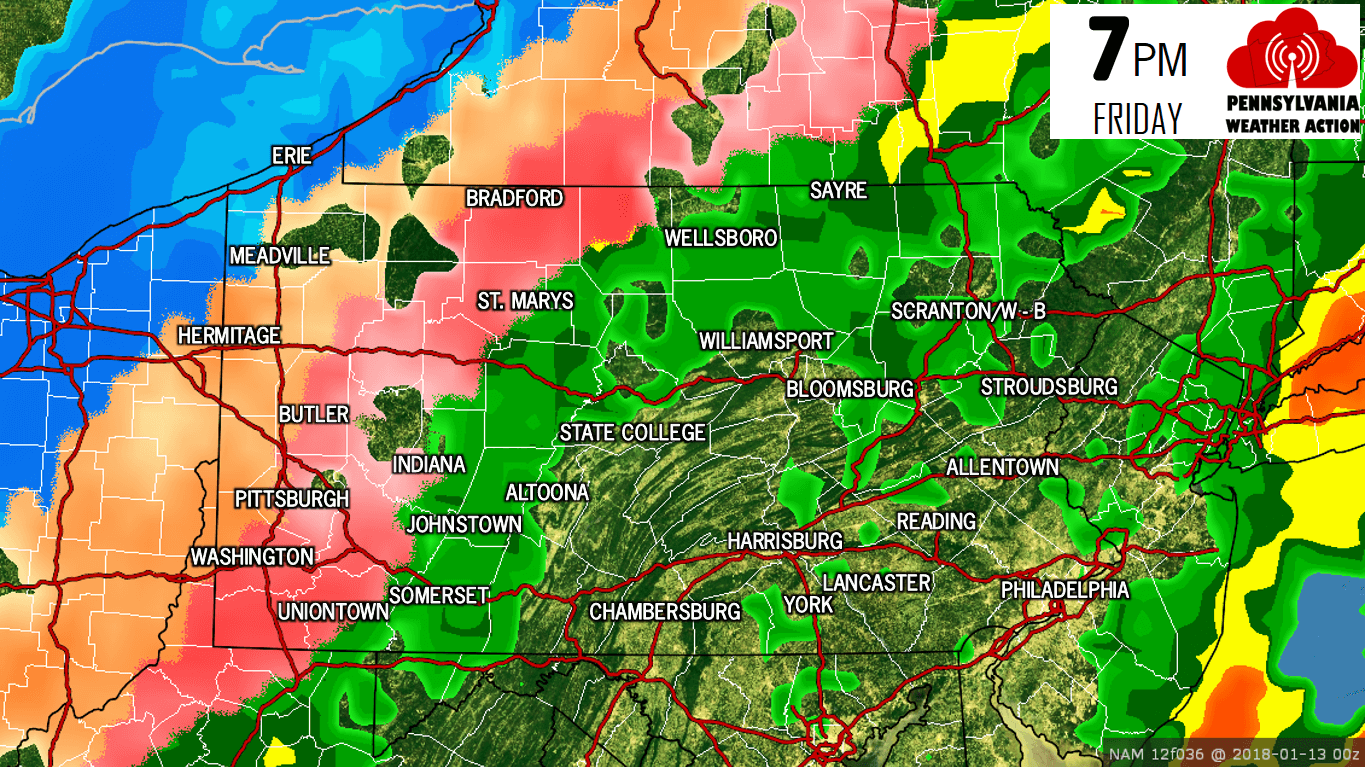
All locations will begin as rain Friday. The changeover from rain to frozen precipitation will occur first in Northwest Pennsylvania Friday afternoon. By Friday Evening, much of Western PA will be seeing wintry precipitation. Here is the NAM Model for 7 PM Friday:
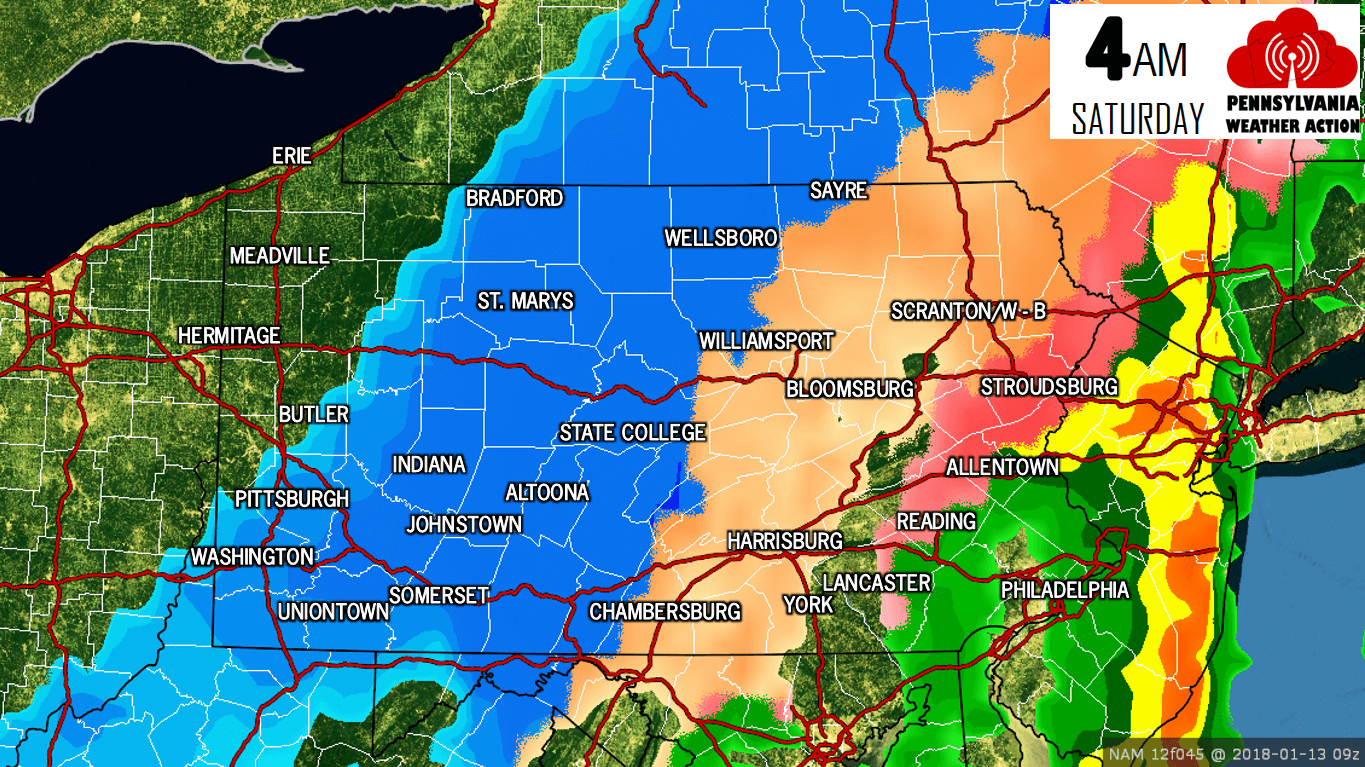
As we continue through the night Friday and into the early parts of Saturday morning, temperatures will continue to crash as the arctic front moves southeast. A change over to freezing rain and sleet will take place for much of Central Pennsylvania as we approach midnight Saturday morning and steady to heavy snow will begin to really come down over Northwest Pennsylvania.
Going forward to 4:00 AM Saturday morning, about 75 percent of the state is experiencing some form of winter precipitation. Areas south and east of interstate 78 will likely stay a plain rain throughout most of this event:
With that being said, all areas throughout our state will experience the arctic front. So even the locations that receive all rain from this storm system, will experience a flash freeze. This can be just as dangerous as receiving freezing rain. If you plan on traveling late Friday night and throughout the day Saturday, be prepared for dangerous travel conditions.
Below is our updated snowfall forecast followed by our freezing rain/ice accumulation forecast.
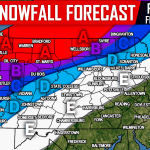
SECOND CALL SNOWFALL FORECAST
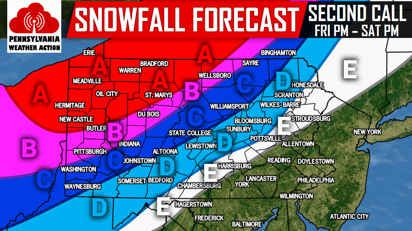 Area A: 6 to 10 inches of snow is expected after the changeover from freezing rain/sleet to snow Friday Night from west to east. Travel will be very hazardous due to a layer of ice under the snow.
Area B: 4 to 6 inches of snow is expected after the changeover from freezing rain/sleet to snow Friday Night from west to east. Travel will be hazardous due to a layer of ice under the snow.
Area C: 2 to 4 inches of snow is expected after the changeover from freezing rain/sleet to snow Friday Night into Saturday Morning from west to east. Travel will be difficult due to a layer of ice under the snow.
Area D: 1 to 2 inches of snow is expected after the changeover from freezing rain/sleet to snow Friday Night into Saturday Morning from west to east. Travel will be difficult due to a layer of ice under the snow.
Area E: A coating to 1 inch of snow is expected after the changeover from freezing rain/sleet to snow Friday Night into Saturday Morning from west to east.
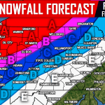
SECOND CALL FREEZING RAIN/ICE FORECAST
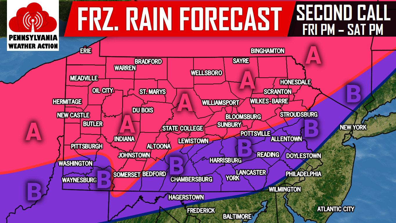
Area A: .10 to .25″ of freezing rain/ice accumulation expected after the changeover from rain to freezing rain Friday Evening from west to east. Travel will be very hazardous.
Area B: .01″ to .10″ of freezing rain/ice accumulation expected after the changeover from rain to freezing rain Friday Night from west to east. Travel will be very hazardous.
For more updates regarding this significant winter storm, like our page on Facebook by clicking here>>>Pennsylvania Weather Action’s Facebook Page
Get our app for interactive radar, NWS alerts, and more >>>Click here to download our app!
Share the important forecast with your family and friends using the button below!
You must be logged in to post a comment.