UPDATE: As of lunchtime Wednesday, most model guidance has trended towards only isolated thunderstorms this evening and early Thursday morning, as opposed to a large complex of storms.
Let me start by saying, of all the severe thunderstorm outlooks we have done this year, this one is probably the most difficult. The models are indecisive, with some guidance suggesting a large complex of strong to severe storms moving through at differing times Wednesday, and other guidance showing much less.
This will be a nowcast situation come Wednesday afternoon, which we will keep you updated on over on Facebook. We are going to do future radar timing below, but take it with perhaps a few grains of salt. The hourly forecast won’t be able to tell you much either. On Wednesday, we highly recommend using the minutely forecast and/or the radar.
FUTURE RADAR TIMING
Some model guidance shows a broken line of severe thunderstorms on the leading edge of a complex of heavy rain, namely the HRRR and RRFS models. However, as of Tuesday evening, the Hi-Res NAM shows only very isolated thunderstorms. But we do believe if it happens, timing will be just after dinnertime across Western PA up and down I-79. Below is HRRR model future radar for 8ish PM Wednesday.
Already heading into late Wednesday evening, storms are expected to push east onto the Allegheny Plateau by around 10ish PM Wednesday. Not everyone will see severe weather. Many people may only see ordinary thunderstorms and 30-40mph wind gusts, if this MCS (mesoscale (meaning small area) convective system) comes to fruition. Here is future radar for 10ish PM Wednesday.
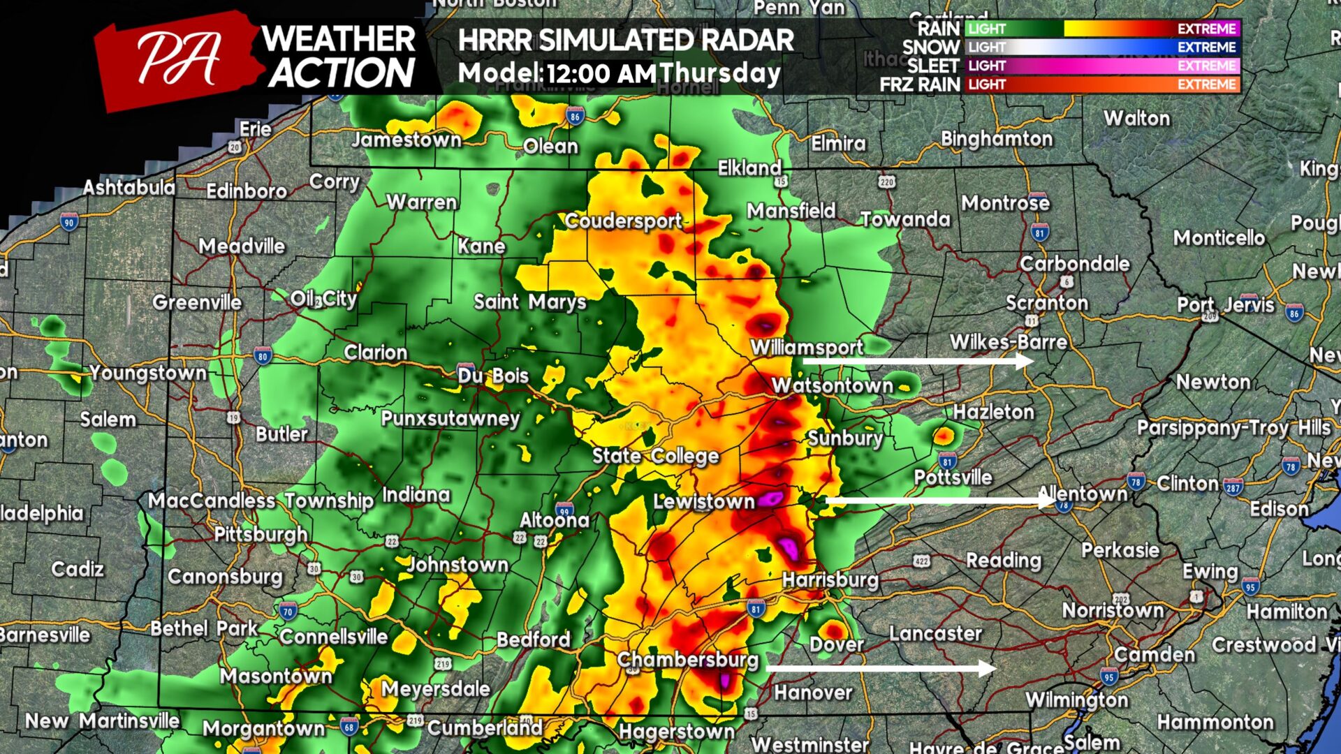
Not often do we see a large complex of strong to severe thunderstorms march across the state at such a late hour, far past the window of maximum daytime heating and instability. This would be something noteworthy if it indeed happens. By 12:00 AM Thursday (midnight Wednesday night), the HRRR has the thunderstorm cluster reaching the Susquehanna Valley as seen below.
Now after midnight, especially in late August, is where we would expect a storm complex like this to fall apart. However, that’s not what the HRRR suggests. We are skeptical to believe there will be much severe weather past midnight, and believe this will evolve into mainly non-severe storms by the early hours of Thursday morning. Below is HRRR future radar for 2:00 AM Thursday.
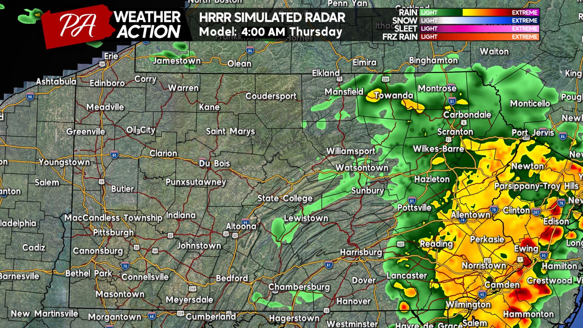
And finally push into the pre-dawn hours of Thursday, the HRRR takes this complex of storms all the way to the Delaware before significantly weakening it. We don’t buy this solution, and think it will be leftover rain showers if the storm complex forms to begin with. Below you’ll see future radar for 4:00 AM Thursday.
WEDNESDAY EVENING – THURSDAY EARLY MORNING SEVERE THUNDERSTORM THREAT OUTLOOK
If you skipped all the way down and missed key details, know that this outlook is based on the expectation of the MCS (thunderstorm cluster) forming in the first place. If it doesn’t form like some model guidance suggests, we will probably only see isolated storms.
Area A: Scattered strong to severe thunderstorms possible Wednesday evening through early Thursday morning. See timing and storm motion above. Scattered damaging winds are the main concern, so please secure anything outdoors that may blow away in strong winds. Flash flooding and hail are secondary, mainly minor concerns.
Area B: Isolated strong to severe thunderstorms possible Wednesday evening into early Thursday AM. View more timing info above. Isolated damaging winds are possible, but the vast majority of gusts will be well below 60mph. Flash flooding is a minor concern, and that risk mainly pertains to Northern PA.
As mentioned, this will be very much a now-cast situation. The fastest way for us to share live information is through our Facebook channel, which is a new feature. Join the message channel here.
Consider sharing this article with friends and family who will find it useful below!


You must be logged in to post a comment.