
We are off to a quiet start to severe weather season, with the exception of the Pittsburgh Area. Very dry conditions have been persistent over the past several weeks, leading to near-drought conditions. The pattern may get a bit more active soon, but we have a lot of ground to make up.
Wednesday Thunderstorm Timing
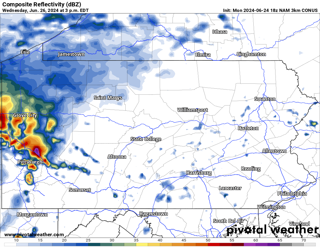
Thunderstorms are expected to develop near the Ohio border by early Wednesday afternoon, quickly pushing into the Pittsburgh Area around 1-3 PM Wednesday. These storms will be strengthening as they move east, with areas east of the Pittsburgh Metro more probable to experience severe thunderstorms.
Below is Hi-Res NAM model future simulated radar for 3:00 PM Wednesday, showing the storms push through Southwest PA. Usually storms are 1-2 hours ahead of what models indicate, especially at this stage.
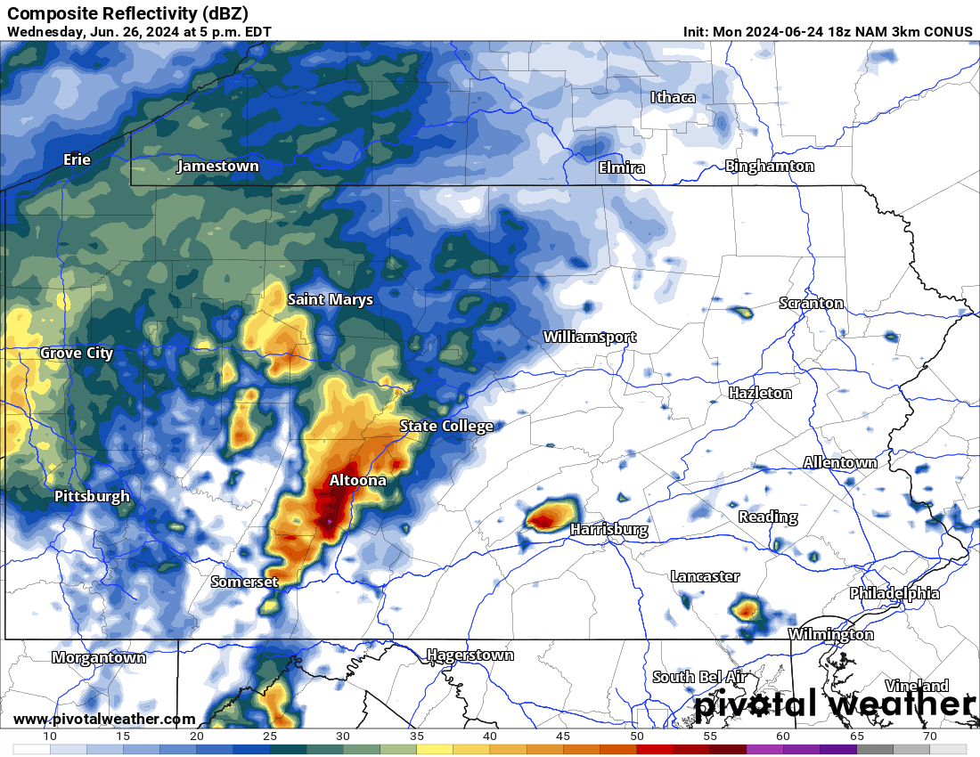
Storms will continue to push east over the Alleghenies in the mid and late afternoon hours of Wednesday. This is when scattered significant severe thunderstorms will begin to be possible, with dynamics in place for some supercell thunderstorms. Damaging winds and hail are the main concerns, but a few brief tornadoes are certainly possible with enhanced instability and ample shear overhead.
A few lone supercells may also develop in the Susquehanna Valley late Wednesday afternoon, and these will pose the greatest tornado threat. For now, the tornado threat looks to be around a 1 in 20 chance of a tornado within 20 miles of you if you’re in Area A on the map later. This means a couple tornadoes are possible throughout the entirety of the area.
Here is Hi-Res NAM future radar for 5:00 PM Wednesday evening. As mentioned, storms will probably move a bit faster than what models show.
Between 5 – 8 PM Wednesday is when the highest threat for severe thunderstorms will be, as they move into the Susquehanna Valley. Models are wavering on just how far north the threat will be, but we are going with a more northerly solution, similar to what the Euro model is projecting. This means we expect severe storms to be possible in Northern PA, rather than exclusively in Southern PA.
The most recent run of the Hi-Res NAM as of Monday evening, the time at which this article was typed, doesn’t look overly impressive in terms of the future radar. However other solutions have a much more expansive broken line of potent thunderstorms extending from the Mason-Dixon Line all the way to Williamsport by dinnertime Wednesday.
As always, we are not promising that every area will see severe weather. In fact, most areas won’t. If everyone saw 60 MPH wind gusts and hail, it would be one of the biggest severe weather days in history. We don’t think a derecho is in the cards. As you can see below, a few storms may fire in Southwest PA again Wednesday evening. Below is future radar for 7 PM Wednesday.
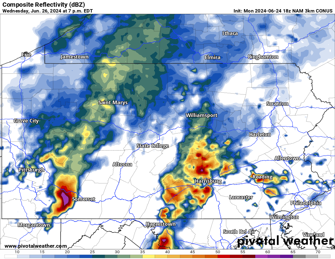
Scattered strong to severe thunderstorms will then push into Eastern PA around sunset Wednesday. Even if your location doesn’t experience significant impacts from these storms, you will get some rain at the very least, unlike yesterday (Sunday). The greatest severe threat will probably be north and west of the Philadelphia Area.
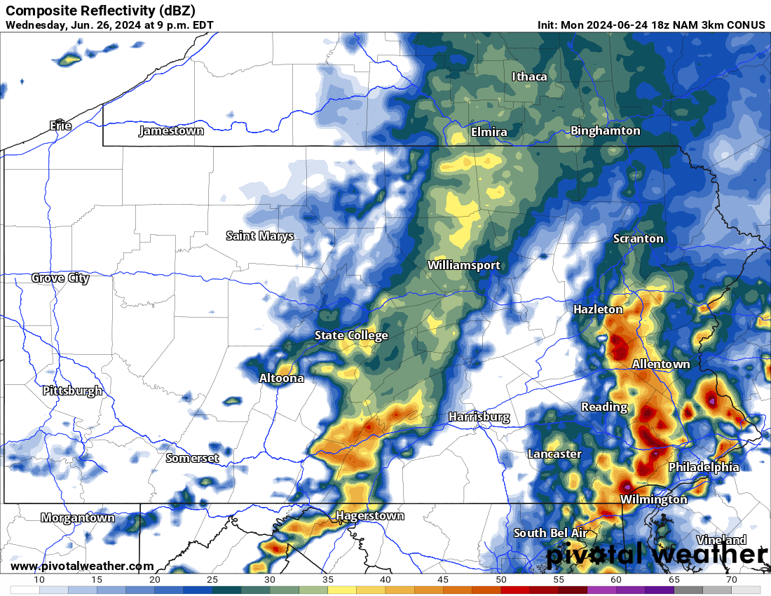
It’s a good thing the Phillies game is at 1:10 PM Wednesday, as the game should be dry. Here is Hi-Res NAM future radar for 9:00 PM Wednesday. The leftovers of some storms may push through Central PA by this time as well.
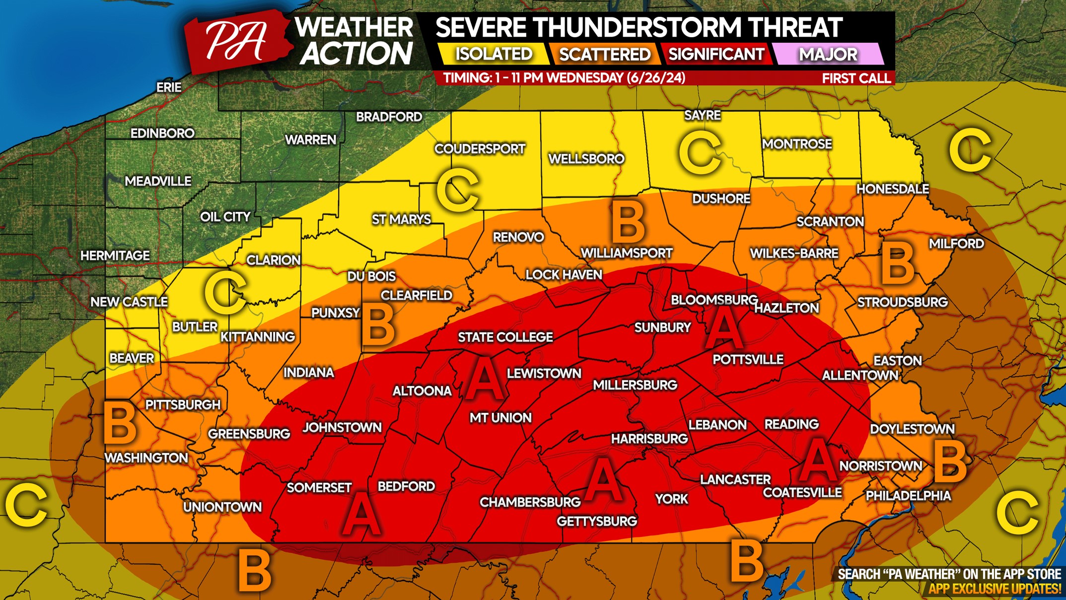
Wednesday 6/26 Severe Thunderstorm Threat in PA
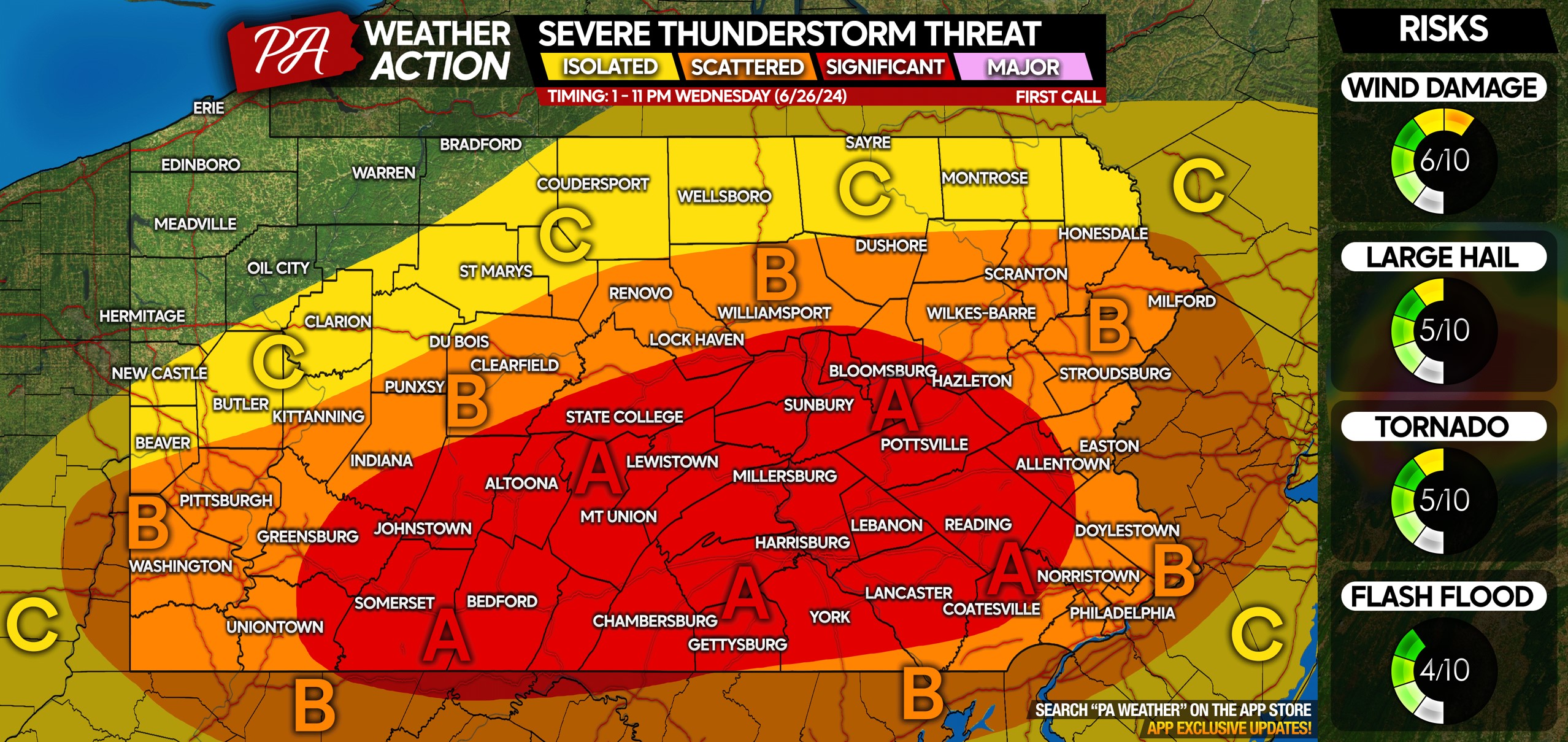
PA is a large state, and generalized timing isn’t practical. View more specific timing for your area above!
Area A: Scattered significant severe thunderstorms possible. Damaging wind gusts of 60 MPH and large hail are the main concerns, with a few tornadoes also possible across the entirety of this area.
Area B: Scattered strong to severe thunderstorms possible. Isolated damaging wind gusts of 60 MPH and large hail are the main threats, with a very isolated tornado not out of the question.
Area C: Isolated strong to severe thunderstorms possible, with wind gusts of 40-55 MPH and small hail possible.
A lot of people have outdoor plans Wednesday evening, so don’t forget to pass this article along to friends and family using the button below!
If you’re reading this on NewsBreak or on Facebook but you don’t follow us, you can start following us below!


You must be logged in to post a comment.