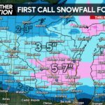
A system cutting to our west will bring the area rain on Wednesday along with a cold front, dropping temperatures. By Thursday winter-like temperatures will return and with temps falling into the teens and twenties Wednesday Night and Thursday Night, the stage will be set for some snowfall in much of the state.
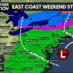
At this point we are confident there will be at-least a few inches of snow throughout the state Thursday Night. There is widespread model support of this especially across the southern half of the state. The big question that remains is, will the low pressure that develops in North Carolina move up the coast or head out to sea? Also, where will it head off the coast?
The European model indicates a strong low pressure moving off the Carolina Coast, only delivering one or two inches of snow to the majority of the state because it does not bring the system up the coast. However, as of lately the European model has been relatively off of its game. Furthermore, its ensembles are shifting north steadily and could end up much farther north by the time Thursday rolls around.
The GFS model indicates a solution similar to the European, however the GFS predicts the low pressure will be farther up the coast when the system moves out, bringing a bigger hit with potentially moderate snowfall accumulation to Southern PA. With that said, we are not making a First Look Snowfall forecast until Tuesday Evening.
Finally, the Canadian model along with the NAVGEM model deliver much bigger of a hit to Central and Eastern Pennsylvania, bringing the coastal low pressure up the coast, spreading significant amounts of precipitation into areas with subfreezing temperatures.

At this point, we are not favoring one certain track, because we all know how models have been this winter. With that said, either way it’s likely an inch or two of snow will fall in nearly all of Pennsylvania Thursday Night caused by the original low pressure not fully weakening as it moves into the area.
As we move into March, sun angle will become an issue and snow will not stick to paved surfaces as easily. However, the snow will begin Thursday Night with temperatures in the 20s and we do expect it to stick to almost all untreated surfaces. Once again, the minimum with this event looks to be an inch of two of snowfall throughout the state and the maximum is a significant snowfall, only if the low pressure moves up the coast.
We will have another update on this snow event Tuesday Evening. We will go into what areas of the state will see the biggest impacts from this storm, stay tuned. Be sure to like us on facebook if you have yet to! >>> PA Weather Action facebook page. Stay safe everyone.
Share this weather update with family and friends!


You must be logged in to post a comment.