


A strong cold front will move through the area Thursday, reactivating the lake effect snow machine. Snow will begin across Western PA Thursday Night, with the heaviest snow likely Friday. Pittsburgh will see about 2-4″ of snow, with its northern suburbs picking up 4-6″.
The Laurel Highlands, especially around Somerset and Johnstown, will benefit from upslope activity, resulting in persistent snowfall. Around 6-8″ of snow is likely across these areas.
Here is our complete snowfall forecast map.
SNOWFALL EXPECTED THURSDAY – SATURDAY
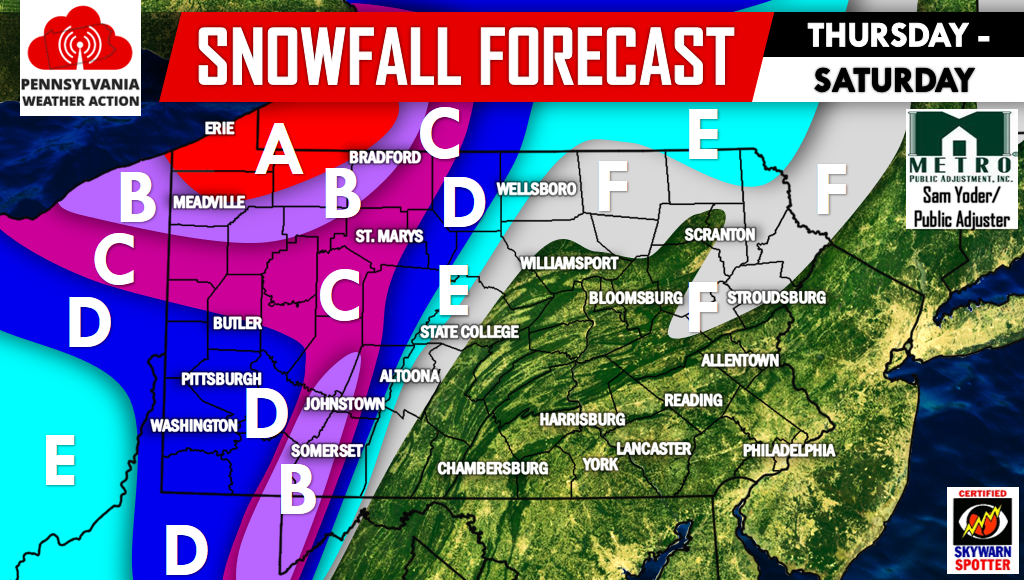
Area A – Snowfall accumulation of 8-12″ expected.
Area B – Snowfall accumulation of 6-8″ expected.
Area C – Snowfall accumulation of 4-6″ expected.
Area D – Snowfall accumulation of 2-4″ expected.
Area E – Snowfall accumulation of 1-2″ expected.
Area F – Snowfall accumulation of <1″ expected.
Shortly after this article is posted, we will have another article regarding the cold and snowy conditions expected for the month of February. Be sure to catch that article by liking us on facebook >>> Click here to like PA Weather Action on Facebook!
If you or your friends and family live in areas expected to pick some snow throughout the next few days, remember to share the forecast with them by clicking an icon below! Stay safe!
You must be logged in to post a comment.