
Since this morning’s update regarding Hurricane Matthew there has been plenty of waffling with model guidance. The good news is, guidance is suggesting a less of an impact for areas North of Virginia, but the bad news is, for areas along the Southeast and Mid-Atlantic Coast, they are in store for one of the worst hurricanes to hit the East Coast in several years.
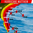
Here’s a latest look at the hurricane models: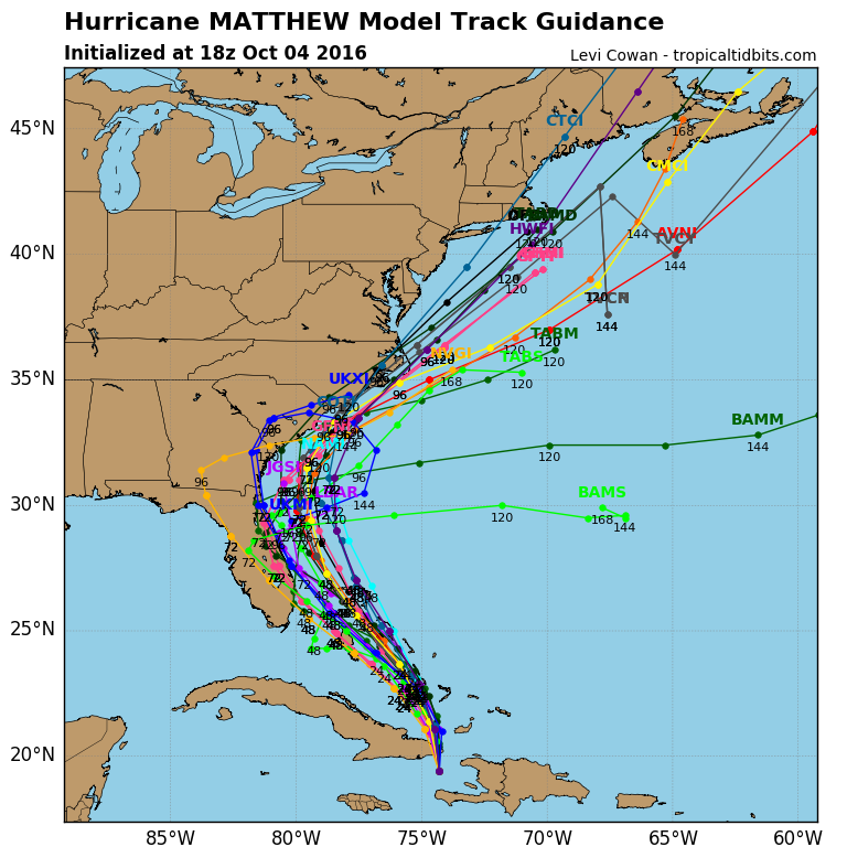
Many make a landfall anywhere from the Florida Coast to the North Carolina Coast. But there seems to be an agreement now that once it reaches the Carolina Coast, Hurricane Matthew should bend Northeastward and spare much of the Northeast from a significant impact including PA.
Here’s our latest look at potential tracks: 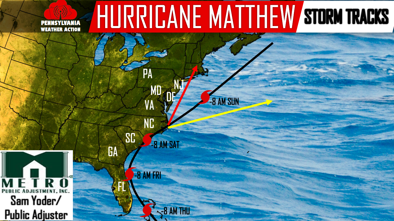
Black Track – Most likely to occur, right around 60% confidence. This is a serious impact from Florida to the North Carolina Coast, but spares everyone North of the VA/NC border from the worst impacts.
Yellow Track – 20% confidence. This would lead to an out to sea solution after it has already done its damage from Florida to the North Carolina Coast. This would lead to no impacts for PA and the Northeast.
Red Track – 20% confidence. If Hurricane Matthew were to take this track, this would lead to serious impacts all the way up through the Northeast. With significant impacts back as far as Eastern PA.
If you notice, the time-frame for PA remains the same. We are looking at Saturday Afternoon through Sunday Morning.
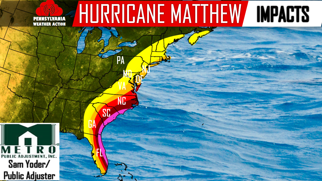
This is our current thoughts in regards to the impacts that will be felt across the East Coast:
Pink – Serious impacts will be felt. These areas need to be evacuated or start preparing immediately.
Dark Red – Major impacts. These areas too need to prepare immediately. Coastal areas need to evacuate.
Red – Significant impacts. This does extend into portions of extreme Southern Maryland. Prepare now, but at this time, evacuation is not necessary.
Orange – Moderate impacts will be felt. This extends into Maryland, Delaware, New Jersey, Long Island, Connecticut, Rhode Island, and Massachusetts.
Yellow – Minor impacts. This does include the Eastern half of PA. Right now it looks to remain a close call. Breezy conditions with some rainfall are possible Saturday Afternoon through Sunday Morning.
We are still 4 days away from potential impact, so we will have rainfall totals as well as wind maps in the coming days. Please like us on our Facebook page for the latest >>>PA Weather Action on Facebook!
You must be logged in to post a comment.