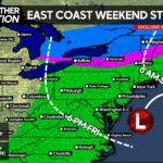
With steady rain Wednesday across the state, there will be some clearing in the evening. Yes, we are in February but conditions Wednesday will be very spring-like. Some thunderstorms are likely to develop late afternoon across Southcentral PA and move east into Southeast PA.
With the primary risk of tornadoes down in Southern Virginia and Eastern NC, even our area could see strong to severe storms producing scattered damaging winds and locally heavy rainfall that could lead to flooding. The thunderstorms will move west-to-east and the highest convective available potential energy levels look to be from Lancaster County to Franklin County.
We have placed a sizable area of the state in a marginal risk of strong to severe storms along with a sliver of Southcentral PA in a slight risk. For those in or on the edge of the slight risk region, you have a 20% chance of being impacted by a severe thunderstorm and a 40% chance of being impacted by a strong storm under severe limits.
Here is our exclusive FutureCast Radar illustrating what areas could be hit by these thunderstorms and around what time they will be affected. Every radar frame is one hour.


You must be logged in to post a comment.