October is a month consisting of rapidly dropping temperatures. October 1st, average highs are in the low 60s to low 70s. October 31st, highs average only in the upper 40s and 50s. Some years are different than others of course. In 2011, a winter storm moved through the region just before Halloween, blanketing much of the state with over a half foot of snow. So what will the rest of October bring us this year?
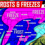
Temperature swings will likely continue into mid and late October. Below average temperatures will dominate the upcoming week with the exception of Thursday. Lows Sunday and Monday Night will dip down near freezing in parts of the state. The following week beginning the 16th, ridging will likely occur resulting in above average temperatures potentially lasting the entire week.
The last week of October does look on the chilly side at this point. With that said, it’s difficult to accurately predict what will occur. There is the potential for widespread freezes and possibly even first flakes of the season in mountainous regions of PA the final week of October. The most important word of that sentence is potential.
Remember to like us on facebook to stay updated as we head into the winter by clicking here!