


Hurricane Hermine will make landfall in Northern Florida tonight. Over the past few days, there have been model inconsistencies (very shocking, we know) regarding where the storm will head next. Even though the track is never set in stone, we can now zoom in on its immediate impacts on our area.
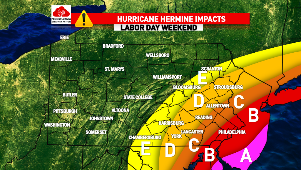
Below there are five zones, A is highest impact, E is slight impact. Here are a few more details.
ZONE A – This area will see significant impacts from Hurricane Hermine. Wind gusts of 40-60+ MPH are expected along with 2.5-5″ of rain. All elevations below 2 feet will see flooding (immediate coastal areas).
ZONE B – This area will see moderate impacts from Hurricane Hermine. Wind gusts of 30-50 MPH are expected along with 1.5-3″ of rain. A 50 mile shift of the track could make a large difference in this region.
ZONE C – This region will see low impacts from Hurricane Hermine. Wind gusts of 25-40 MPH are expected along with 1-2″ of rain. A shift in track could make a large difference when it comes to impacts in this zone.
ZONE D – This region will see slight impacts from Hurricane Hermine. Wind gusts of 20-35 MPH are anticipated along with .5″ of rain.
ZONE E – This region will see minimal impacts from Hurricane Hermine. Wind gusts of 20-30 MPH are possible along with .25″ of rain.
As mentioned, the track of Hurricane Hermine is not 100% known. Stay tuned for updates on our facebook page! Like it by clicking here if you don’t already. Stay safe!
You must be logged in to post a comment.