
With cooler days, earlier sunsets, and the start of Penn State Football, we are about a month away from leaves turning in parts of Pennsylvania. Soon after, the first freeze and then sunsets before dinner. Fall goes quick here in PA, with November being a dramatic realization that the things we look forward to each fall are over.
Jump to:
Typical Weak La Nina Winter Pattern
Typical Neutral ENSO Winter Pattern
Best Analogs for this Upcoming Winter 2025-26
Latest Climate Models for Winter 2025-26
2025-26 Winter Temperature, Precipitation & Snowfall Forecast: First Look
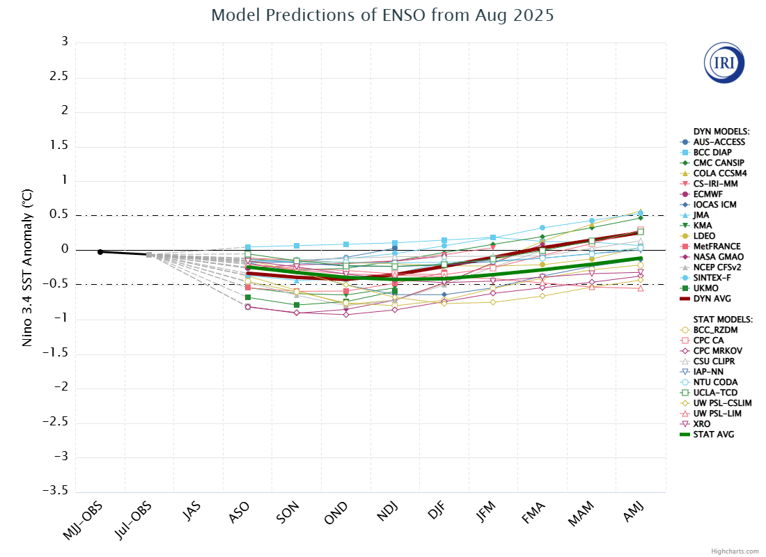
When we do seasonal forecasting, it’s much less about the precise details of each week and more about the grand scheme of things. One of the reasons we are able to have a general idea of how the winter will go is the El Niño–Southern Oscillation (ENSO), which we know as either La Nina or El Nino.
Models are extremely good at forecasting the ENSO many months in advance, and this upcoming winter we will either see a weak La Nina or a neutral phase. Here is a chart showing the ENSO forecast, with -0.5C or colder being the threshold for La Nina.
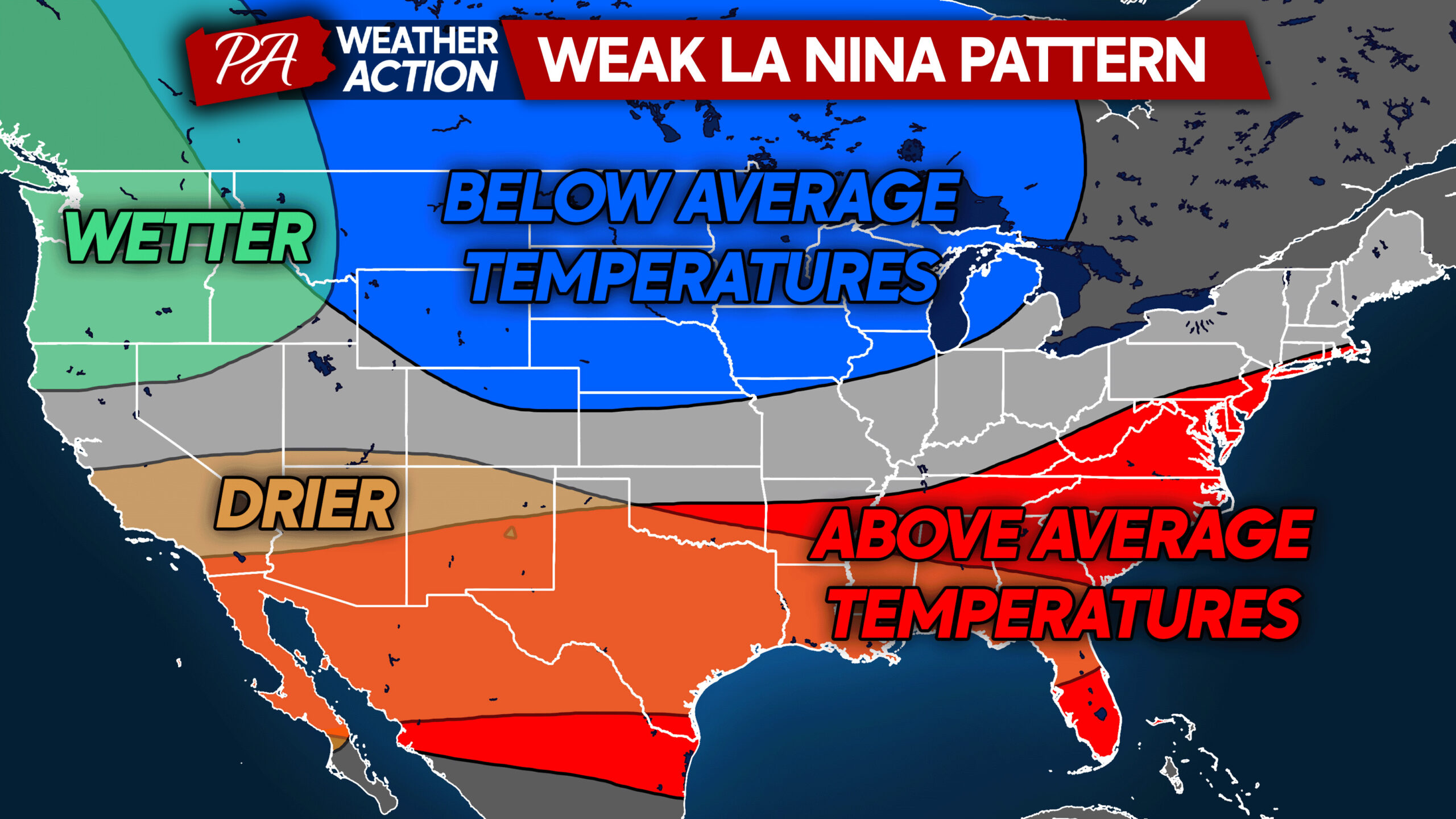
Typical Weak La Nina Winter Pattern
During Weak La Nina winters, the polar jet stream often dives down from Alberta and into the Northern Plains and Upper Midwest, giving them colder than average conditions. The subtropical jet stream, which is largely responsible for those large East Coast Nor’easters is subdued, making big storms less likely.
Above average temperatures are common across much of the Southern US, and this can sometimes include parts of Pennsylvania as well. But since we are looking at only a very weak La Nina, similar to last winter, a few major cold air intrusions are still probable.
Drier than normal conditions can occur in our area as well. Right now, we are looking at a rapid-onset drought potential with dry conditions likely continuing through October.
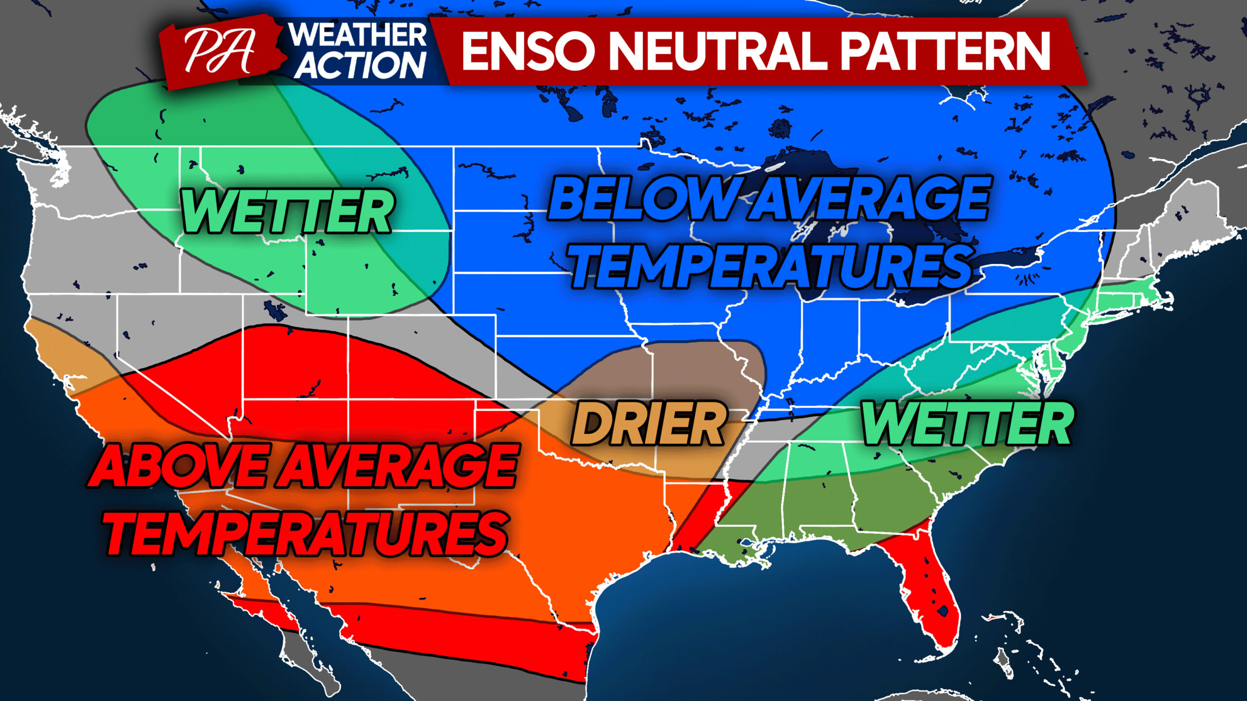
Typical Neutral ENSO Winter Pattern
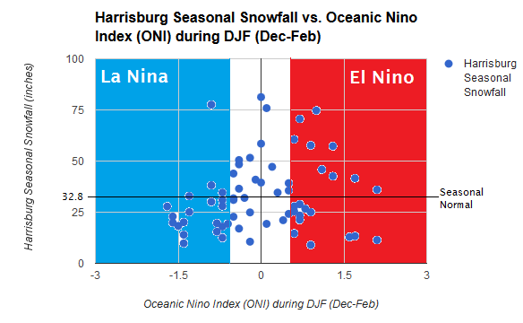
Neutral ENSOs statistically yield the highest average winter snow totals of any ENSO phase, but it’s no guarantee. The chart below is a bit old, as Harrisburg’s average has fallen thanks to the last several winters. Neutral is that area in white, and you can see it’s the only ENSO phase that is more likely to deliver above average winter snowfall to Harrisburg. This trend continues in most places in Pennsylvania.
It comes as no surprise that below average temperatures typically extend to Pennsylvania in neutral winters. Sometimes, but not always, we also see a more active subtropical jet stream that can bring nor’easters up the coast. However, that’s more probable during El Nino.
Neutral ENSO winters are some of the hardest to predict, because what happens is left up to other teleconnections around the world. Sometimes they favor our area for cold and snowy conditions, other times they don’t. And it’s equally as difficult to predict how those teleconnections will behave 6 weeks in advance versus 16 weeks.
Best Analogs for this Upcoming Winter 2025-26
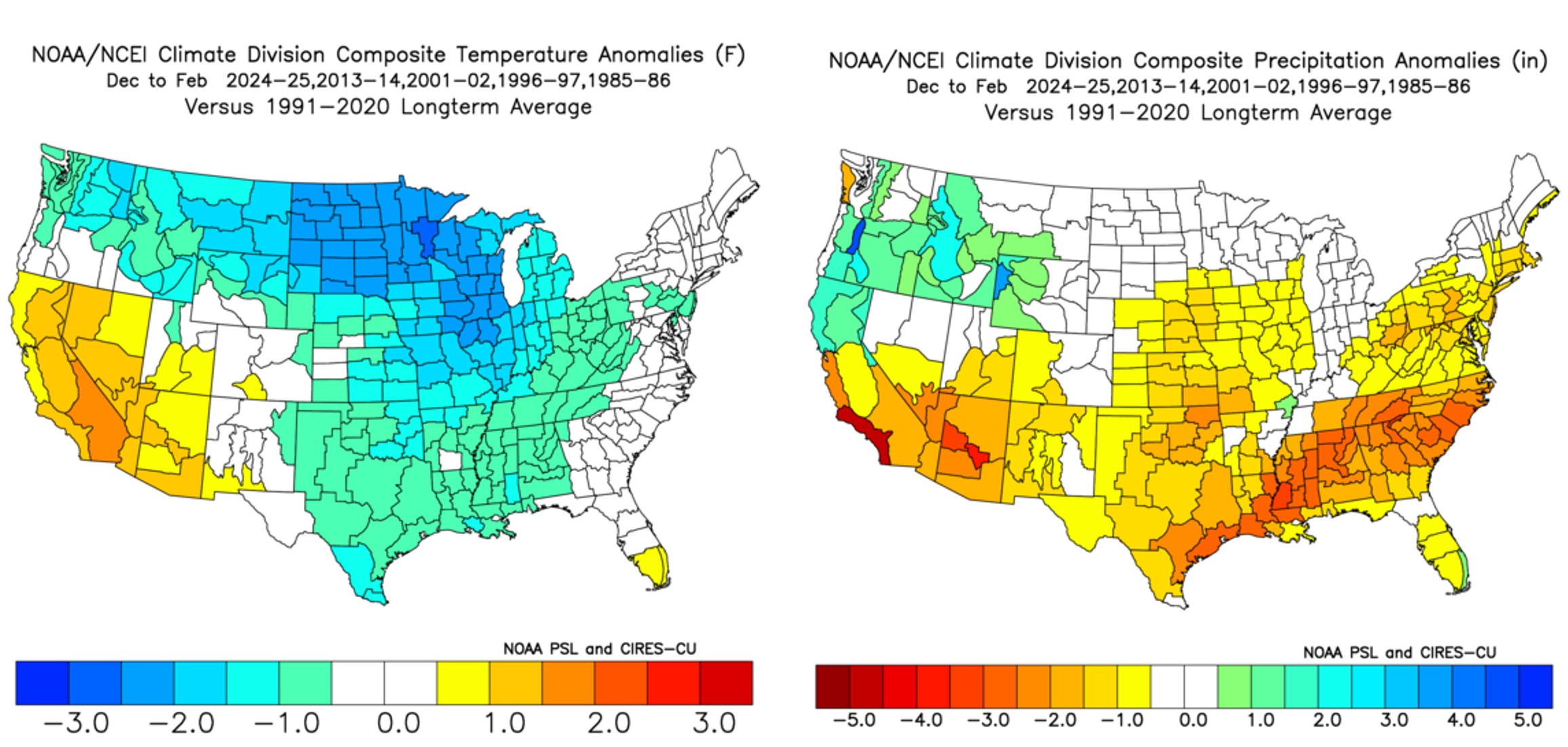
One of our greatest tools for seasonal forecasting is analogs, or winters from the recent past that have similar conditions at this point in time approaching the winter. We try to use analogs from the last 30 years, and compare them to the 1991-2020 climate. Using 30 year climate averages is the standard in climatology and meteorology.
Last winter is great analog, although the Earth was still feeling the impacts of the previous year’s strong El Nino. Other close analogs are the winter of 2013-14, which was very cold and snowy. But then you have 2001-02, which was the opposite.
When you combine all five winters, the outcome is a slightly colder, but near average winter temperature-wise in Pennsylvania, with the heart of the cold anomalies in the Midwest. Slightly drier than normal conditions are also favored.
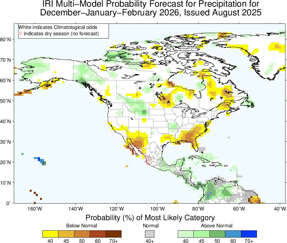
Latest Climate Models for Winter 2025-26
Climate modeling is another tool we use, though it still has a ways to go, just like seasonal forecasting. But it’s worth noting that both the European and American climate modeling suggests a large area of average temperatures in the Central and Eastern US. This is significant in itself, because overall they’re more likely to predict above average temperatures for a given point in the world.
You also see above average temperatures favored in the Southwest and on the West Coast, which is an indicator that ridging may be focused out west, which often places Pennsylvania in colder conditions.
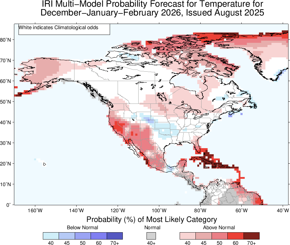
Precipitation is favored to be below average in the Southeast, more reminiscent of a Weak La Nina pattern. This creeps up the coast to include places nearby to PA as well.
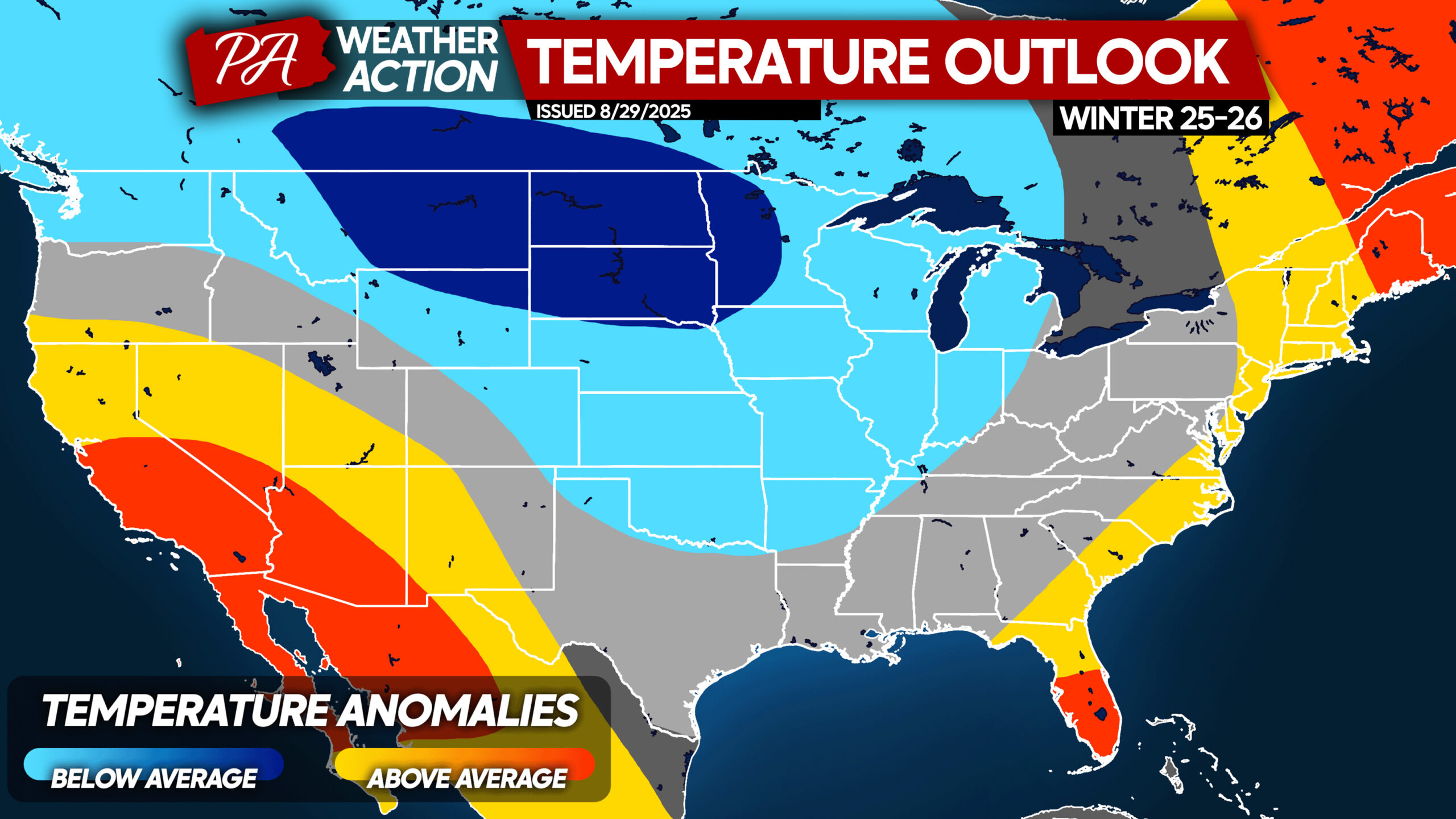
2025-26 Winter Temperature Forecast: First Look
This outlook, similar to NOAA’s Climate Prediction Center’s, is a first look at what temperatures are favored to be based on the ENSO, analogs, modeling, and a bit of the forecaster’s own thinking. Keep in mind, this is for the whole season and there will be ups and downs.
Colder than normal anomalies are more probable to be focused in the Midwest and Northern Plains, with average temperatures favored in Pennsylvania. Slightly above average temperatures may occur along the East Coast, with warmth more favored in the Southwest US.
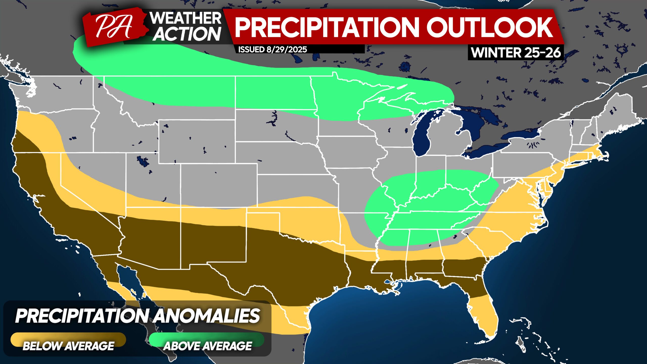
2025-26 Winter Precipitation Forecast: First Look
Like last winter, along with analogs and modeling, slightly drier conditions than usual are favored in parts of Pennsylvania, especially east of the Appalachians. However, much of the interior of PA is favored to see near-average precipitation.
Wetter conditions are probable in the Ohio River Valley and in the far Northern US, with drier anomalies from coast to coast in the Southern US.
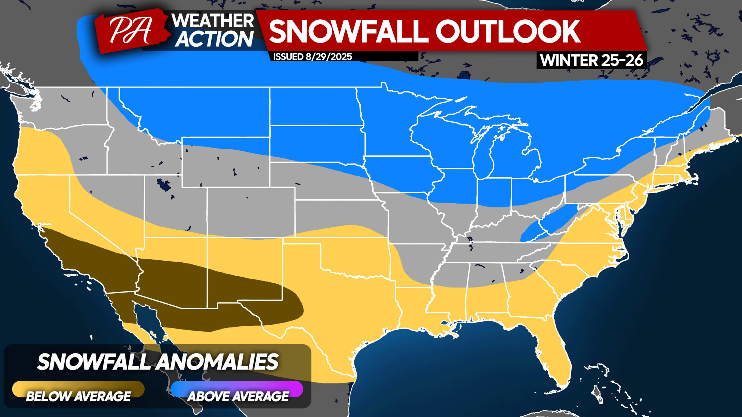
2025-26 Winter Snowfall Forecast: First Look
And for the grand finale comes an early look at snowfall for the upcoming winter. Due to drier than normal conditions being favored along the coast, slightly below average snowfall is favored along I-95 including parts of Pennsylvania.
With relatively frequent cold air intrusions, the lake effect snowbelts may see another normal to slightly snowier season, like last winter. This leaves the Appalachian regions of Pennsylvania in the middle, where roughly average snowfall is expected. If you don’t know what your average snowfall is, check out this article.
That’s been our first look forecast for the winter of 2025-2026. We do our best to give you the most honest forecast based on observations, analogs, modeling, and a bit of our own thinking.
If you found this forecast interesting to read, don’t forget to pass it on to friends below!
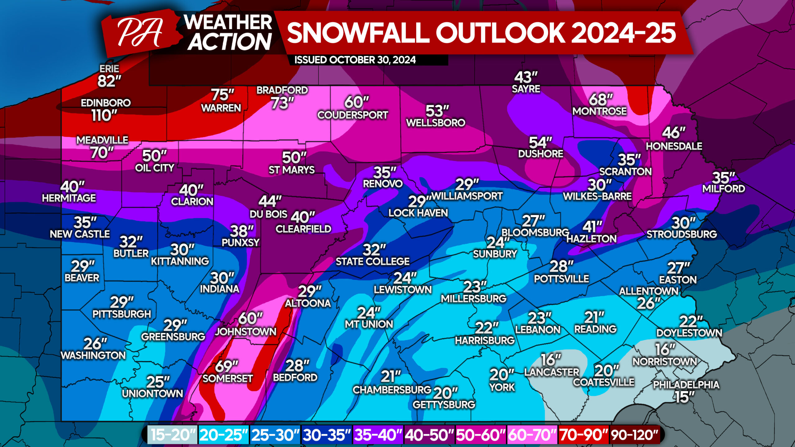
While we forecasted warmer than normal conditions last winter and it ended up being around average, here is a look at the snowfall totals we predicted ahead of last winter in our October winter outlook, followed by the actual observed seasonal snowfall totals.
Winter Forecast (Last Season):
Observed 2024-25 Seasonal Snowfall Totals:
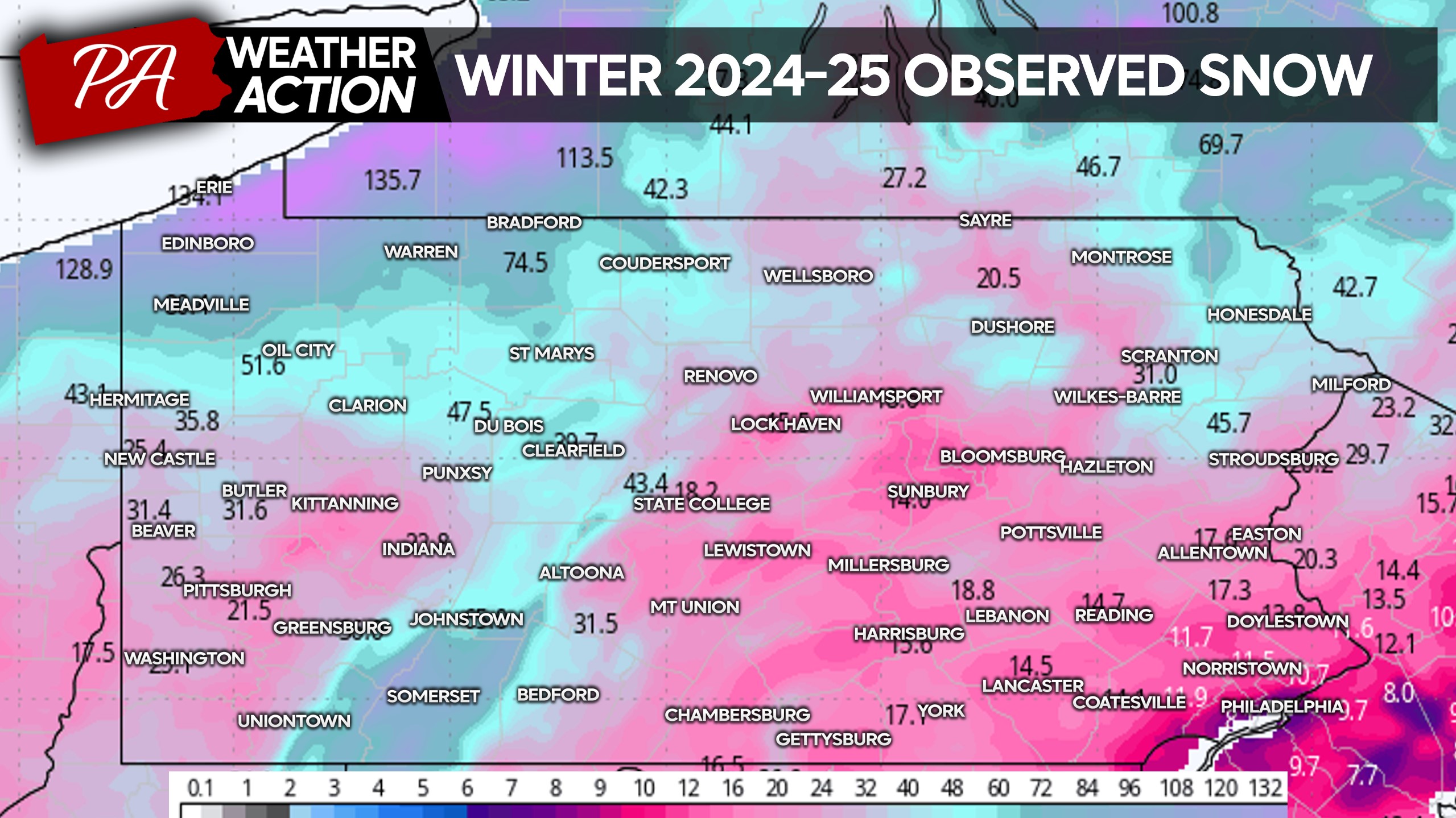
A few areas overachieved, and a few underachieved. But as a whole, our forecast was one of the most, if not the most accurate seasonal snowfall forecasts in the state. So while we acknowledge this winter forecast is earlier than most, our motive remains to be accurate!
You must be logged in to post a comment.