
There is now the threat of a widespread ice storm in Central and Western Pennsylvania. While upper levels warm Saturday Morning, moderate precipitation will continue in many areas with surface temperatures well below freezing. Deep valleys will hang on to cold air the longest Saturday, with some areas not reaching the freezing mark until mid-afternoon.
Below is the RGEM for 4 AM Saturday Morning.

As you can see, while the overwhelming majority of the state is experiencing snow at this point, freezing rain is beginning over Southwestern PA. Here is the same model for 7 AM Saturday.

By 7 AM, freezing rain will overtake much of Western and Central Pennsylvania. At the same time or just before, a heavy band of snow will likely move through Eastern PA. Finally, here is what the radar could look like by around 10 AM.

Nearly the entire southern half of Pennsylvania is seeing freezing rain at this point, with some snow still persisting in Northeastern PA. This is because upper levels will take the longest to warm in Northeast PA.
There is the possibility that deep valleys in Central PA do not changeover to plain rain. In all other areas, this storm will likely end with a short period of rain. By Saturday Evening, temperatures will be well above freezing.
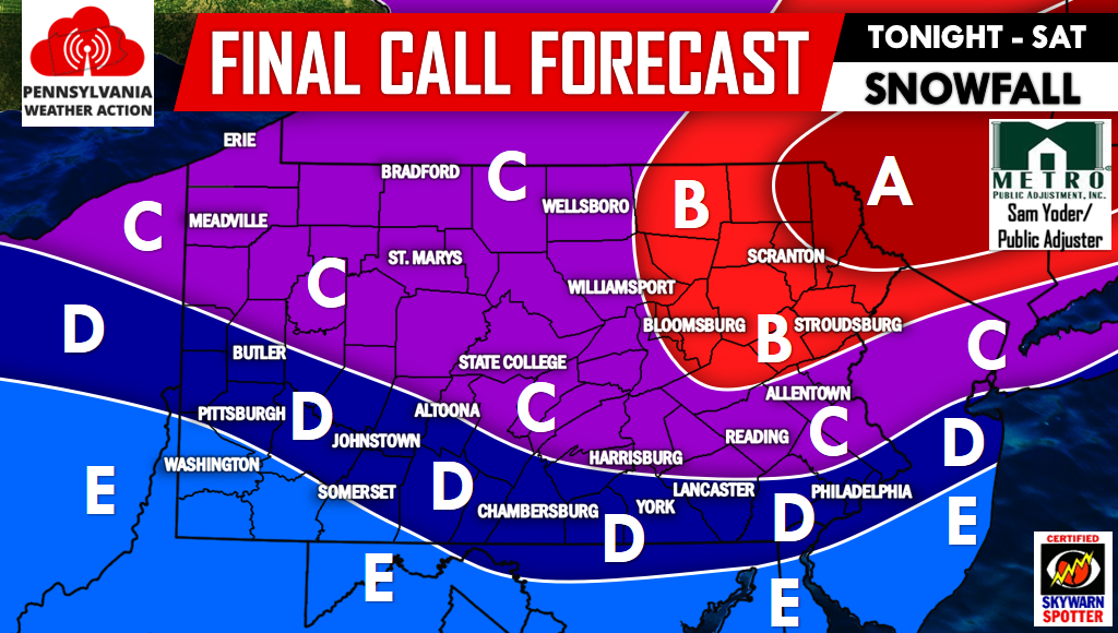
FINAL Call Snow Map
Area A: 6 to 8 inches of snowfall is expected.
Area B: 4 to 6 inches of snowfall is expected.
Area C: 2 to 4 inches of snowfall is expected.
Area D: 1 to 2 inches of snowfall is expected.
Area E: A coating to 1 inch of snowfall is expected.
For future updates be sure to have us “liked” on Facebook by clicking here>>>>PA Weather Action on Facebook!
Please scroll down after viewing this map. As stated earlier, significant ice accretion is expected.
FINAL Call Ice Map
Area A: 0.20-0.35″ of ice accretion on top of the snowfall accumulation. Scattered power outages likely.
Area B: 0.10″-0.20″ of ice accretion on top of the snowfall accumulation. Scattered power outages possible.
Area C: 0.03-0.10″ of ice accretion on top of the snowfall accumulation.
Area D: 0.01″-0.03″ of ice accretion on top of the snowfall accumulation.

We do not advise travel in Area A before 3 PM Saturday, and 12 PM in Area B.
Remember to share the Winter Storm details with your friends and family below, stay safe!
You must be logged in to post a comment.