
We are now within 12-24 hours before the region feels the impacts from Tomorrow’s Nor’easter. Winter Storm Watches have been issued for Northcentral and Northeastern PA with Wind Advisories in Southeast PA.
Guidance has trended colder since our first call last night. This puts many more locations under the gun for a changeover to sleet and/or wet snow later in the day Monday as the Nor’easter begins to really crank off the coast.
To all those weather enthusiasts out there, sit back and enjoy this storm. The radar will be lit up Tomorrow Afternoon and Evening with just about every type of precipitation.
Scattered light rain showers are possible for the southern half of PA overnight and through Tomorrow Morning, however the steadier rain will not arrive until lunchtime.
Below is the latest NAM valid 1 PM Tomorrow Afternoon: Image courtesy of https://truewx.com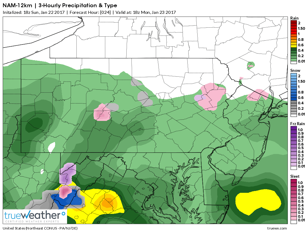
Everyone will still begin as rain, regardless of the cold trend previously mentioned. However, the change to snow and/or sleet has trended farther south and east. As we take the NAM out to Tomorrow Night at 10 PM, the radar is wild: 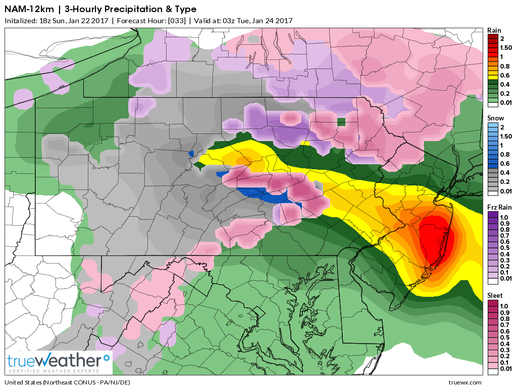
Very heavy rain in the yellows and oranges over Eastern PA and New Jersey, but notice the gray’s and blue’s that are showing up. That is your snow. The pink is your sleet.
This will be a very powerful storm Tomorrow. Areas that do receive several inches of wet snow and sleet, the threat for power outages are possible. And as you head further east in PA, damaging winds in excess of 45-50mph are possible, which will also lead to power outages. If you are planning to travel, leave yourself plenty of extra time to reach your destination. Significant travel impacts are expected.
Tomorrow is an extremely volatile situation. There will be many busts both in places receiving more snow than they were anticipating and also locations receiving more rain rather than snow. This is why all forecasters will tell you they would much rather have an all rain or all snowstorm simply due to the forecast aspect.
So please have us liked on Facebook as we will have updates as we receive the latest information>>>PA Weather Action on Facebook!
FINAL CALL FORECAST FOR MONDAY’S NOR’EASTER
Timing: Scattered showers will overspread southern pa during the overnight hours and push north through the morning hours. Rain will then change to sleet and/or wet snow for central and northern areas in PA by Monday Afternoon and Evening. All precipitation will taper off by early Tuesday Morning.
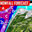
RAINFALL FORECAST
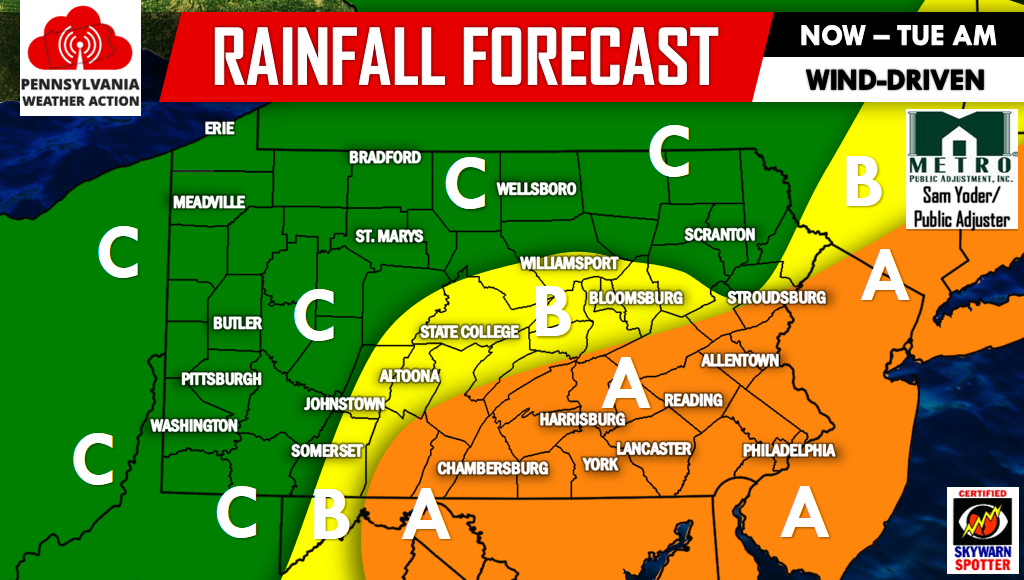
Area A – Rainfall amounts of 1.5-2+” likely. Winds gusting as high as 45-50 mph.
Area B – Rainfall amounts of 1-1.5″ likely. Winds gusting as high as 35-40 mph.
Area C – Rainfall amounts of .5-1″ likely. Winds gusting as high as 25-30 mph.
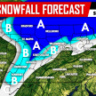
SNOWFALL FORECAST
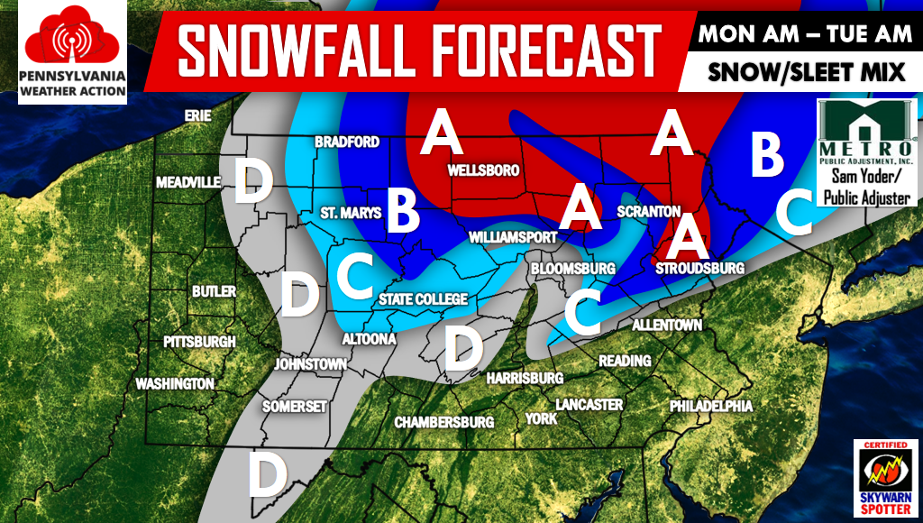
Area A – Snow accumulation of 5-8″ likely.
Area B – Snow accumulation of 3-5″ likely.
Area C – Snow accumulation of 1-3″ likely.
Area D – Snow accumulation of less than 1″ likely.
All other areas will see rain, however locations near Area D could see some sleet or wet snow mix in Monday Evening and Monday Night.
Be sure to have our Facebook page liked for the latest>>>PA Weather Action on Facebook!
Also don’t forget to share the forecast using the icons below! Stay safe!
You must be logged in to post a comment.