
The last two winters have been complete disasters in Pennsylvania for snow lovers and those who rely on winter weather to make a living (or at least a portion of their income). In fact, Harrisburg has seen less snow in the last four winters combined than any other stretch of that time in recorded history. This upcoming winter has made a poor name for itself since the start, with some mentioning the possibility of an historically strong El Nino. It is clear we will not be in that realm. While NOAA has declared we have reached Strong El Nino status, the Multivariate ENSO Index which combines both oceanic and atmospheric variables, actually indicates more of a weak to moderate strength El Nino. The difference in significant, as some of our cold and snowiest winters have come in weak to moderate El Ninos. Whereas strong El Ninos are often warm and rainy, with a massive snowstorm tossed in sometimes to salvage the otherwise uneventful season like in 2015-16. We will try to keep this is reader-friendly as possible from here on out.
How do moderate El Nino winters typically perform in Pennsylvania? If you think back to the last three winters which were all La Nina, one area that really got the short end of the stick was the southeast quarter of Pennsylvania from Chambersburg to Harrisburg-York-Lancaster, and into the Philadelphia Area. That area of Southern Pennsylvania often sees average to above average snowfall in moderate El Nino winters. Whereas interior locations in northern and western Pennsylvania often see below average snowfall. This is due to more coastal storms and systems that slide to our southeast instead of riding up I-95 which has been common in recent La Nina winters.
MONTHLY OUTLOOKS
December
Temperatures: Average (-1° to +2° vs average)
Precipitation: Slightly Above Average
Snowfall: Slightly Above Average
Snow has been missing from many Decembers in the last decade. Contrasting from most winter outlooks, we actually do expect some powder in Pennsylvania this December. Teleconnections such as the MJO, EPO, and PNA (all in the Pacific) look decently favorable for one or two mixed precipitation events, and perhaps a mainly snow event at some point. We expect times of troughing and below average temperatures, followed by breaks where a system comes through and is rain or a mixed bag, followed by cold air and lake effect. The few days where temperatures are well above normal as a system goes overhead will even the anomalies out for the month.
However, it’s hard to fathom we won’t see frozen precipitation in the midst of the various troughs coming through. Overall for December, we expect average temperatures and slightly above average snowfall with an active pattern.
January
Temperatures: Average (-2° to +1° vs average)
Precipitation: Below Average
Snowfall: Below Average West, Average East
January is a big wild card, and a very important month with it averaging more snow than any other month. We expect January to have multiple behaviors. We expect a pattern change around the New Year to a quieter pattern with deep, but not intense troughing centered over the American Coasts, with ridging in the middle.
However, having the base of the trough at our longitude may mean that storms riding across the far Southern US will not come up the East Coast, but rather go out to sea. So while the Southeast US is relatively cool and wet, we may be seeing average temperatures and dry conditions as we watch big storms head east off the Georgia coast. By the end of January, the pattern may become more favorable for one of those storms to come up the coast. Overall for January, we expect below normal snowfall in the western half of PA, with average snowfall in the eastern half, and average temperatures.
February
Temperatures: Below Average (-4° to -1° vs average)
Precipitation: Slightly Above Average West, Above Average East
Snowfall: Slightly Above Average West, Well Above Average East
If you’re looking for a month that will define this winter, it’ll likely be February. After experiencing relatively unfavorable ridging positions and lack of Greenland Blocking in December and January, finally ridging is forecast to favor the Northern Rockies in February. This sets up an ideal storm track for us, as energy rides down the base of the trough axis along the Gulf Coast, picks up moisture, and heads up the East Coast. If there’s going to be a big snow month, especially in the eastern half of Pennsylvania, it will be February.
Chances of significant coastal storms that produce double digit snowfall amounts in the eastern two-thirds of PA are doubled during Moderate to Strong El Ninos, we would be very surprised not to get at least one of those during February. Overall for February, we expect slightly above average snowfall in Western PA, and well above average snowfall in the eastern two-thirds of Pennsylvania.
March
Temperatures: Above Average (+2° to +5° vs average)
Precipitation: Below Average West, Average East
Snowfall: Well Below Average West, Slightly Below Average East
Let’s remember March is five months away, so leave room for error especially with this month. This forecast is largely based on analogs for the upcoming winter and the expectations of a big February. Often times after a 30-45 day period when nearly every teleconnection (MJO, PNA, EPO, NAO, AO) is favorable for cold and snow, a period of quite the opposite conditions follows. Rarely do you get 70 day periods of relentless cold and snow, and we certainly aren’t forecasting that here especially when warmer than average conditions are typical in March during this El Nino phase.
Mother Nature doesn’t have a concept of the calendar, so a big winter storm in early March isn’t impossible, but it would probably be winter’s last hurrah before warm conditions flood in. Overall, we expect above average temperatures especially in middle and late March, with well below average snowfall west, and slightly below average snowfall east thanks to one last small event in early March.
SEASONAL OUTLOOKS
2023-24 Winter Temperature Outlook
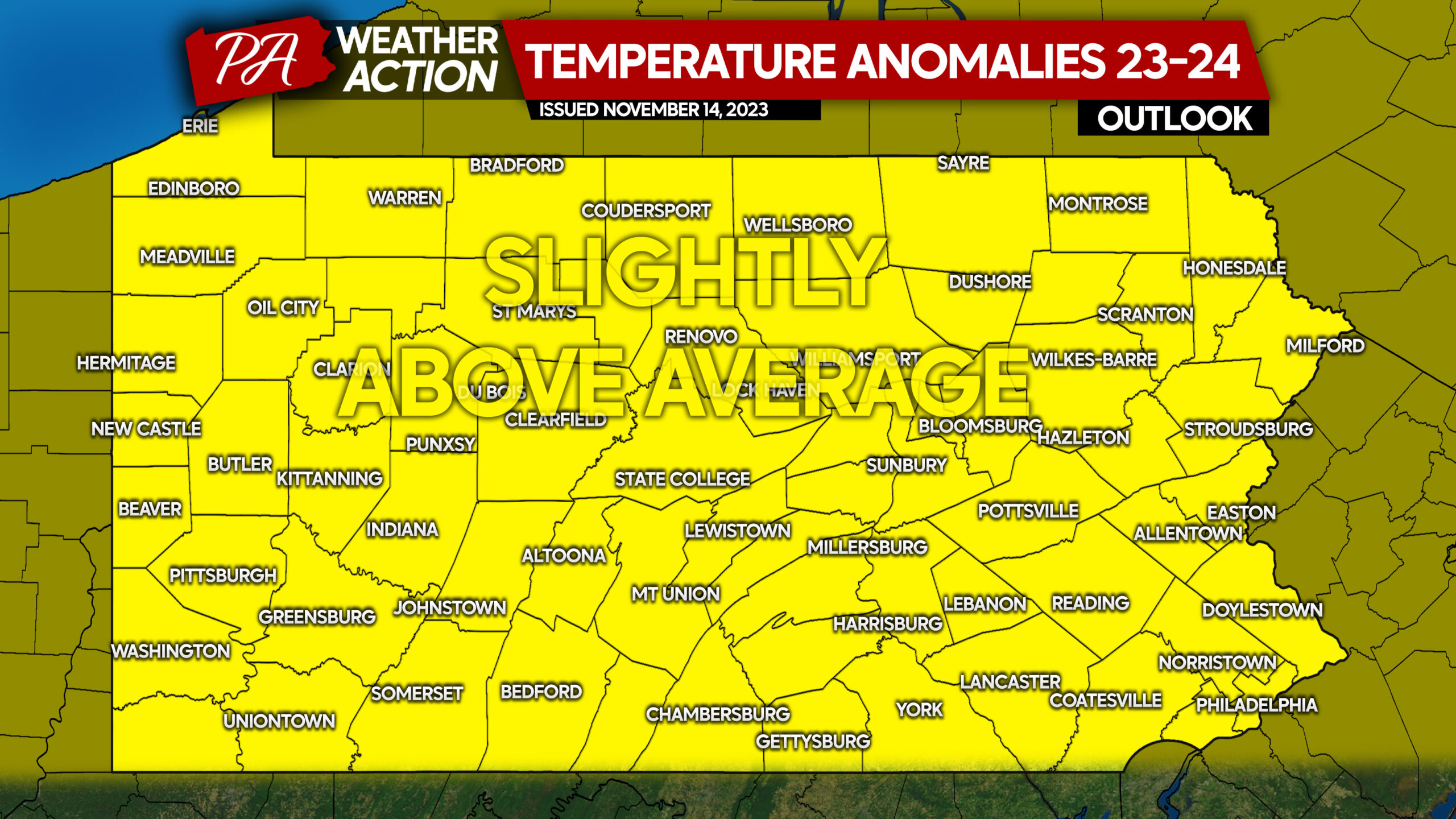
As the monthly outlooks indicate, we expect this winter to be a roller coaster. As you can see, we predict slightly above average temperatures overall but that line disappears at the Mason-Dixon Line. As a whole, this winter should end around 1-2°F above average, which is much colder than the last two winters and similar to Winter 2020-2021.
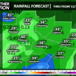
2023-24 Winter Precipitation Outlook
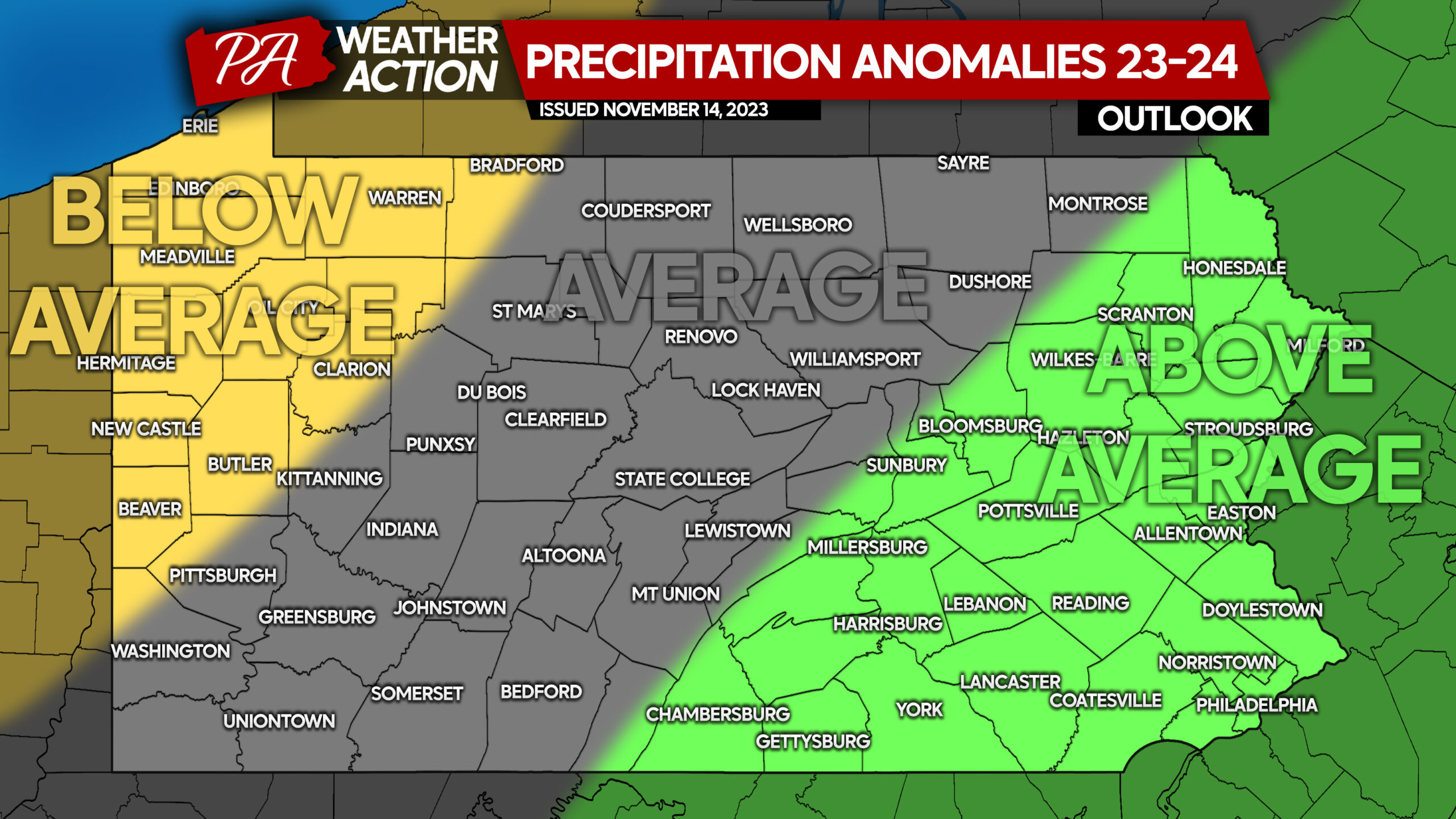
We are predicting above average precipitation along and east of I-81, with average precipitation over much of the Appalachians, and below average precipitation in parts of Western Pennsylvania. The various coastal storms will benefit eastern portions of the state more, and systems that go over our head generally track as far west as I-81, but not directly over the mountains or Western PA.
2023-24 Winter Snowfall Outlook
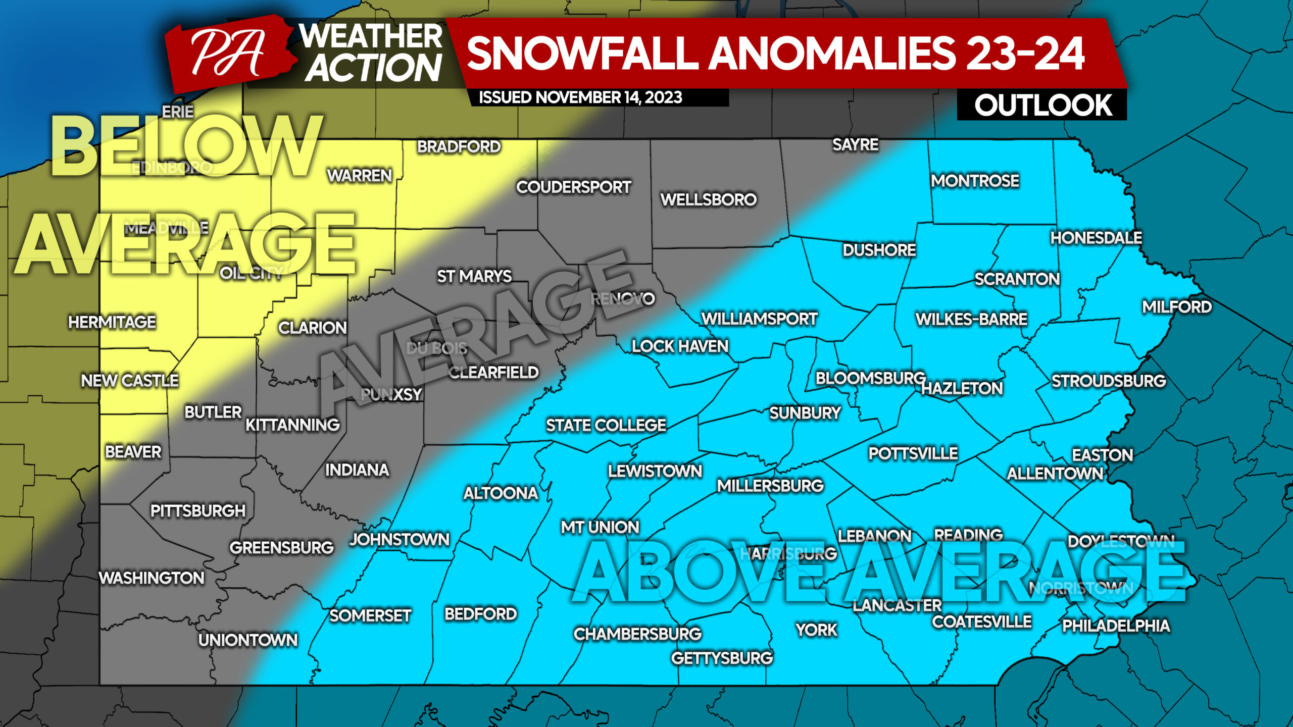
For the first time since Winter 2020-21, we expect above normal snowfall in a large portion of Central PA and all of Eastern PA. For areas more inland like Southwest PA and North Central PA, around average snowfall is forecast. Finally in areas enhanced by lake effect, mainly in Northwest PA, below average snowfall is anticipated.
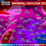
2023-24 Winter Snowfall Totals Outlook
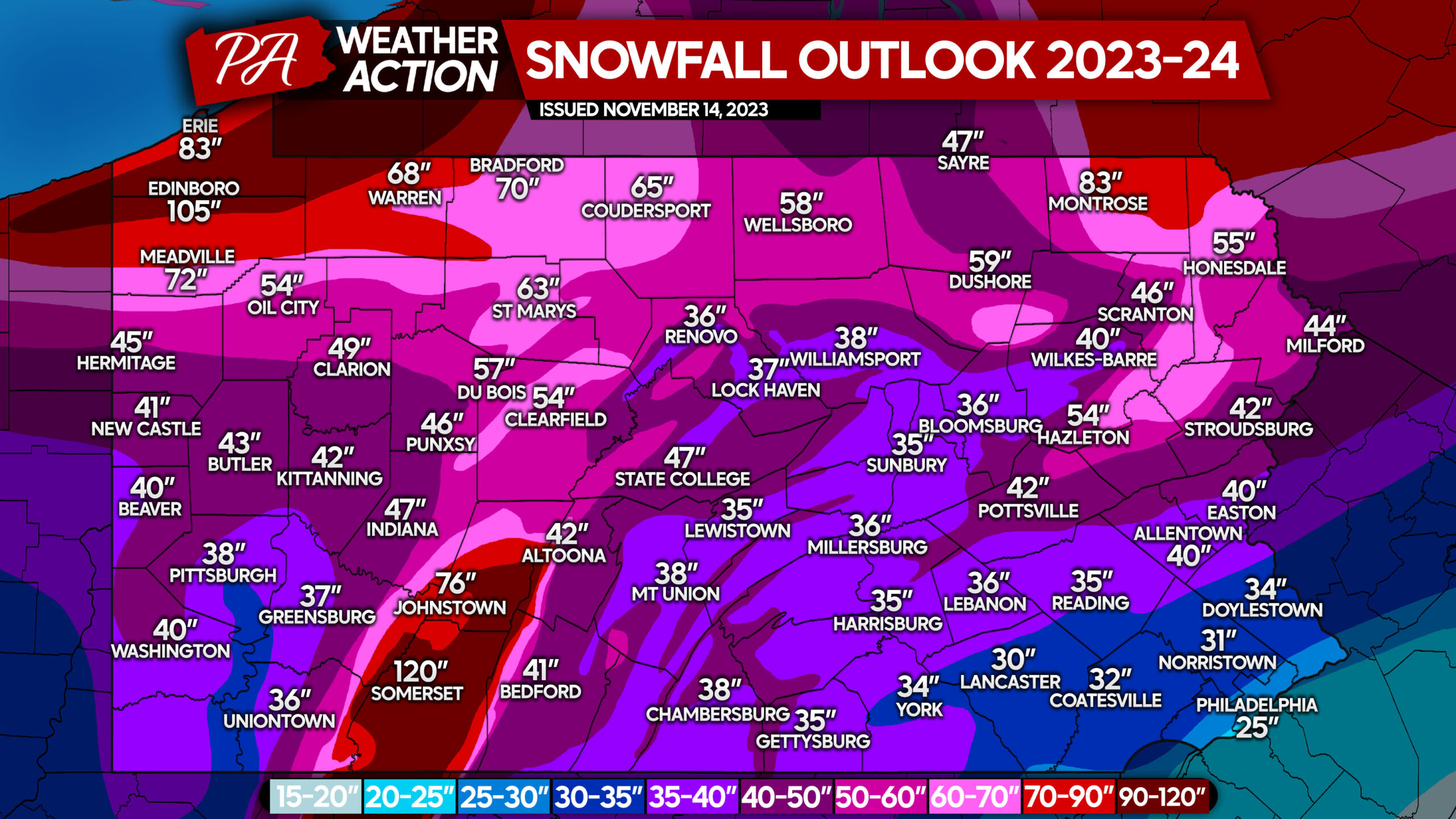
Let’s begin with the obvious. The probability of hitting the nail on the head in more than 20% of cities is very low. Leave a decent amount of room for error with this, although we did take into account the dozens of microclimates across the state mainly driven by elevation. This map reflects the snowfall anomalies that are forecast above, and actually is conservative in above average areas.
All of the totals you see in the above average area are around 110% of average snow, or just 10% above average. But when you’re coming off the absolute disgrace that last winter was, these totals look huge. But they are not, except maybe in Somerset and Edinboro where the occasional igloo will be spotted! Just kidding! But really, this winter is forecast to be refreshing return to normal.
We hope you enjoyed this year’s winter outlook, thank you for reading.
If you don’t already, be sure to follow us on Facebook using the blue banner below! Also consider sharing this outlook with friends, coworkers, family, etc who may be interested!
You must be logged in to post a comment.