
This year, March has been a month that made everyone happy weather-wise. We started off warm, even with a bit of severe weather. Then came the snow, dumping over a foot in some areas in the span of five days. Two days later, many of us were flirting with 70 degrees and it’s been very Spring-like ever since. But unfortunately, teleconnections have flipped favorable for a period of cold and even snow in Western PA. The next two weeks will feature below average temperatures, holding most of our daytime highs in the 40s and 50s. There may be a day or two in the 60s between cold fronts. We know, sigh.
FUTURE RADAR TIMING
Snow squalls will begin to move in from the west around sunrise Saturday morning. Squalls will continue much of the day Saturday in and west of the Laurel Highlands. By late Saturday evening, very light snow showers are expected in SWPA, while light to moderate snow continues overnight into Sunday morning across NWPA. More isolated snow squalls are expected Sunday in Western PA, but the majority of the snow will fall Saturday with the exception of the lake effect belts in Erie, Crawford, and Warren counties. Below is future radar from the Hi-Res NAM model.
SATURDAY – SUNDAY SNOWFALL FORECAST
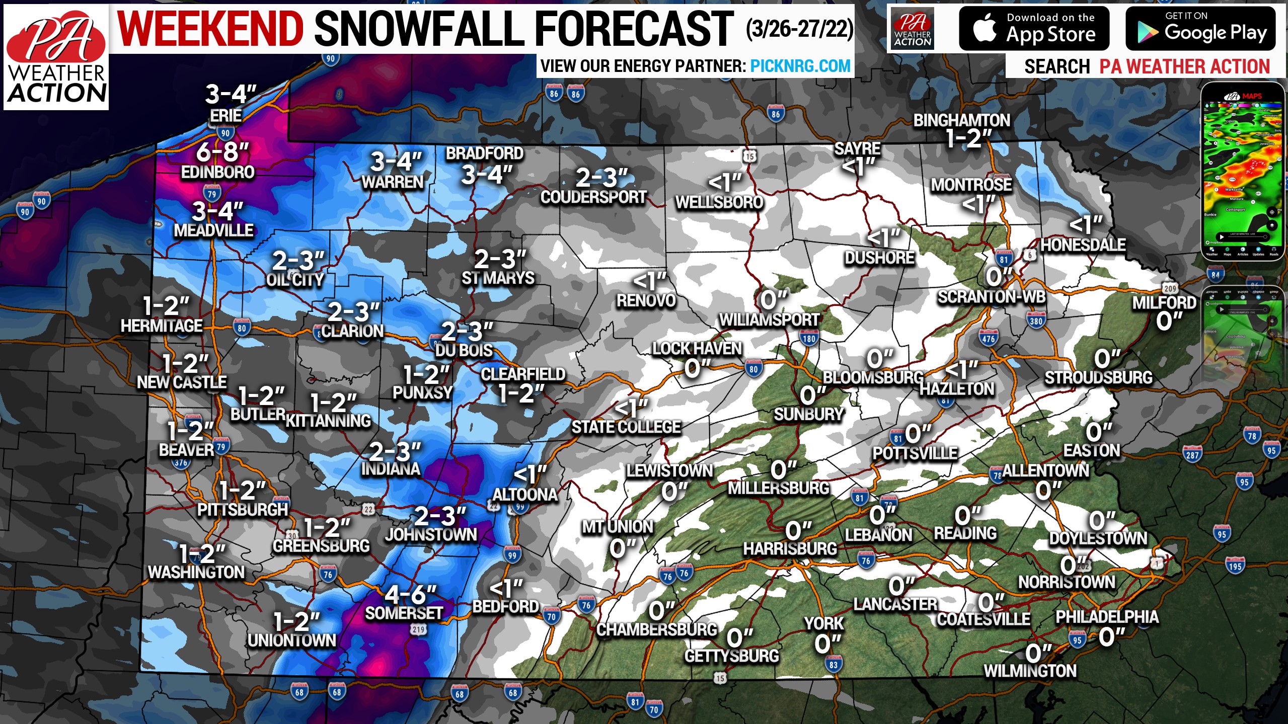
Most of Western Pennsylvania can expect 1-2″ of snow, with the Laurel Highlands & NWPA snowbelts seeing 4-8″. Highest accumulations in the Laurel Highlands will be on west-facing slopes, with highest accumulations in NWPA expected to be about 10-30 miles inland from Lake Erie. In the eastern half of the state, scattered rain showers are possible Saturday and a few snow squalls are possible in NEPA Sunday evening.
Hazardous road conditions are expected in the Laurel Highlands and across Northwest PA, so be sure to take it slow in those areas.
Feel free to share probably the last snowfall forecast of the season with family & friends!
[social_warfare]
Download our app using the banner below!
![]()
You must be logged in to post a comment.