
A cold front will move through Saturday, setting the stage for not only a snowy Sunday in parts of the state, but another week of chilly temperatures statewide. A weak clipper will move through late Saturday Evening, starting as rain for most areas in Western PA and the Laurel Highlands, then changing to snow in some locations just before ending. The bigger story though will be the lake effect snow bands that follow.
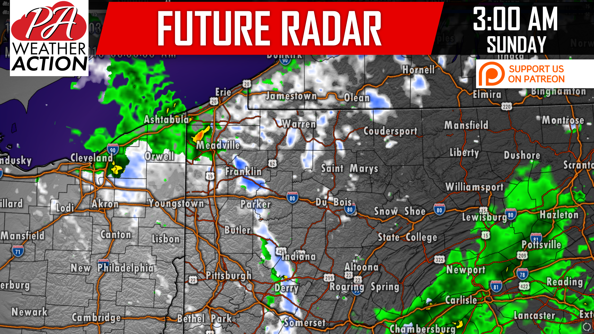
Lake effect snow showers will be found across much of Northwest PA and the Laurel Highlands in the pre-dawn hours of Sunday. Temperatures at this time will be near or sub-freezing in areas above 1500′ elevation in the Northwest PA mountains and Laurel Highlands, likely leading to snowfall accumulations of up to an inch in these areas. Here is the future radar for 3:00 AM Sunday:
That will not be the end of it however, as lake effect “streamers” will continue into the daylight hours of Sunday. While it’s difficult to pinpoint exactly what regions will receive persistent banding, we do have a general idea. Somerset and Cambria County will see off-and-on, but mainly on, snow showers beginning just after 12:00 AM Sunday, lasting until about 12:00 AM Monday. As a result, we expect these areas to pick up a couple inches of snow.
The high elevations of Northwest PA will also see relatively persistent snow showers Sunday, and can expect some snowfall accumulation as well.
FIRST CALL SNOWFALL FORECAST
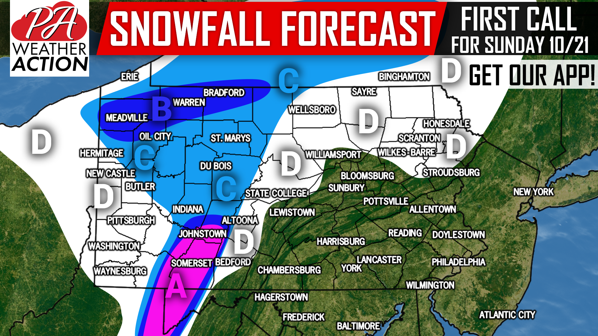
Area A: Periods of low visibility are likely Sunday Morning. Slick roads are possible, especially above 1800′. Snowfall accumulation of 2-3″ is expected, with highest amounts above 2000′, and lowest amounts below 1300′. Johnstown is more likely to get 1-2″ due to low elevation.
Area B: Low visibility and slick roads are possible in locations that see persistent snow banding. Snowfall accumulation of 1-2″ can be expected.
Area C: Most of the snow within this area will fall in the pre-dawn hours of Sunday. Low visibility is possible in heavy snow bands. Snowfall accumulation of up to 1″ is anticipated, mainly on grassy surfaces. However, there may be a few slick spots on the roads in locations above 1700′.
Area D: A few scattered snow showers are possible within this area from the pre-dawn hours of Sunday, into the evening. Snow will be hit-or-miss, and we don’t expect any accumulation more than an isolated coating on ridge-tops.
We will have an update to this forecast Saturday Evening! Download our app for your latest hourly and daily forecast, radar, alerts, and articles >>> Tap Here to Download PA Weather!
If you missed our Preliminary 2018-2019 Winter Outlook, just click this link!
Don’t forget to share this snowfall forecast using the blue button below, have a great weekend!
You must be logged in to post a comment.