
With nearly all of the Lower 48 states experiencing below average temperatures, and some areas extremely below average, you would expect us to be predicting snow. That is not the case, as this low pressure system will move up the Appalachians, before transferring to a coastal low pressure over our heads. The transfer will be too far north for the majority of us to see any snow, so instead we will be dealing with an ice threat across much of the state.
Significant icing is expected in a good portion of the state, and will be worst in the high elevations. Scattered power outages are expected in those areas. We are then tracking another winter storm for Thursday, and that one may bring several inches of snow to most of the state before more ice. Our first call for that storm will likely be on Tuesday.
STORM TIMING
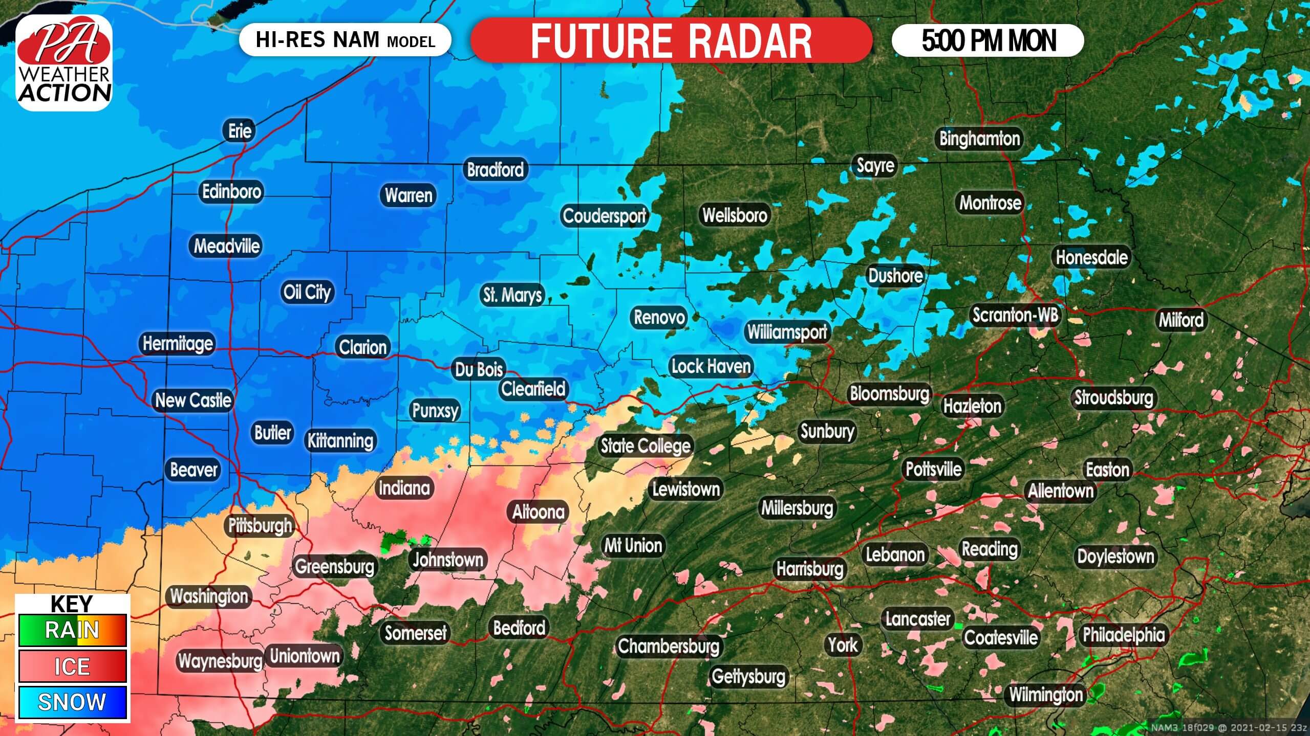
Very light precipitation may occur over the western half of the state Monday morning, but more widespread moderate precipitation won’t work its way in until the early evening. Snow, sleet, and freezing rain will move into western PA right around the evening rush. Below is Hi-Res NAM future radar for 5:00 PM Monday.
As we head later into the evening, precipitation will move east across much of the state. Late Monday evening is when we expect travel conditions to really worsen. Here is future radar for 11:00 PM Monday, showing that snow in the northern tier, sleet in the middle, and freezing rain in southern PA.

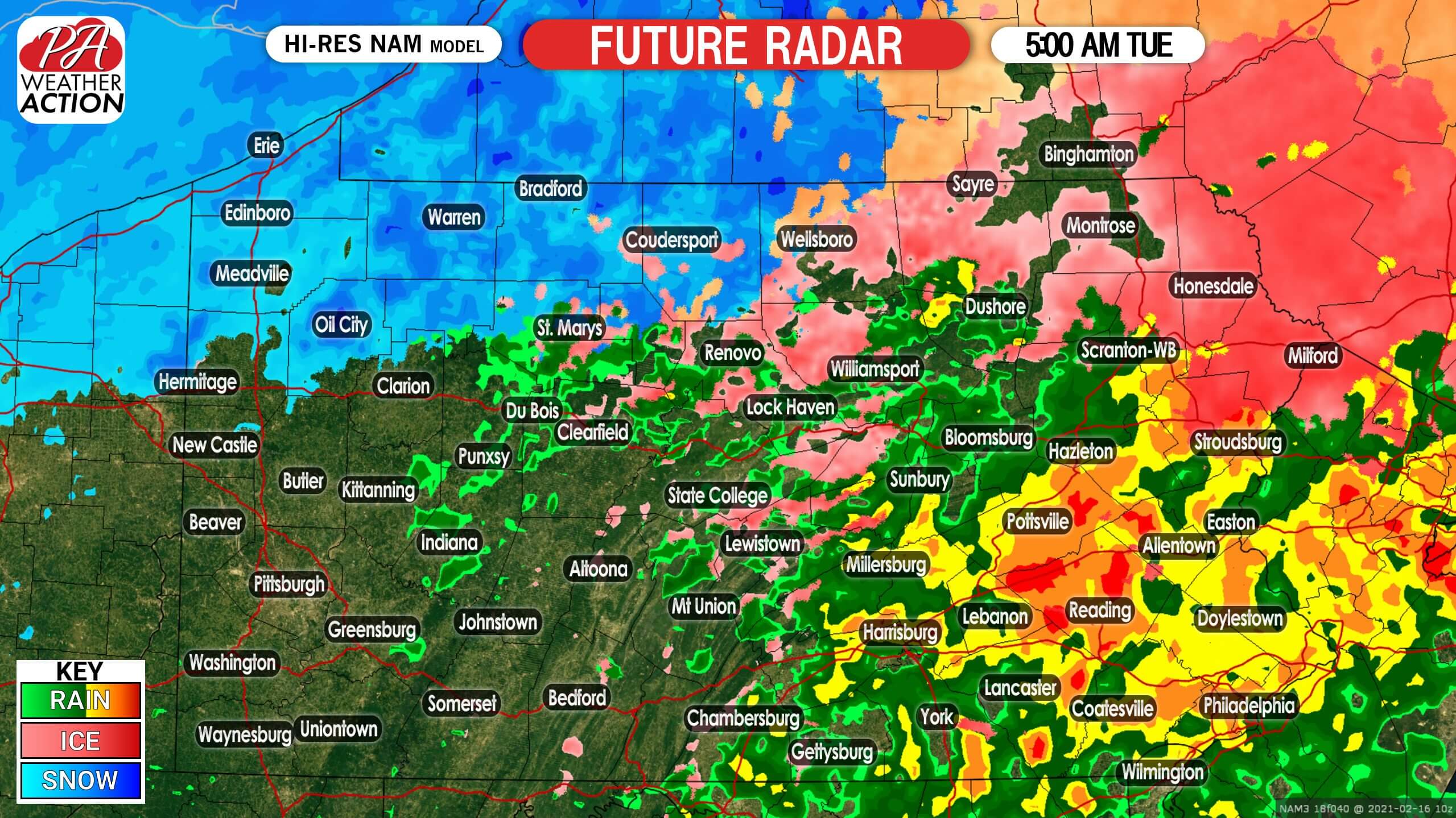
This will be a fast-moving storm. By the Tuesday morning commute, precipitation should be done in western PA and exiting eastern PA. Below is future radar for 5:00 AM Tuesday. As you can see, many of us may just be seeing plain rain by mid-morning Tuesday.
FINAL CALL MONDAY PM – TUESDAY AM ICE FORECAST
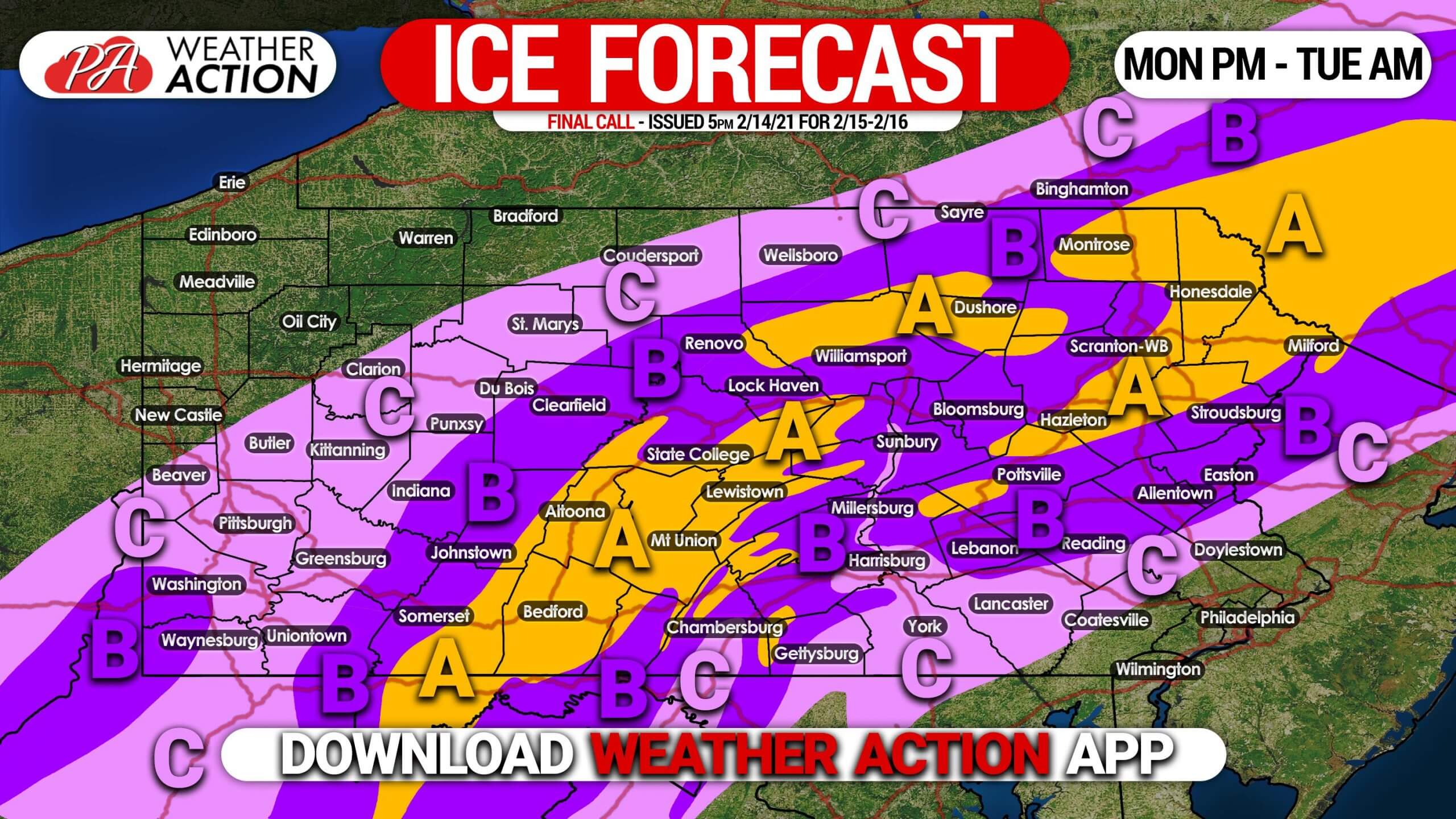
Freezing rain will cause ice to accumulate in these areas.
Area A: Ice accumulation of .25 – .50″ expected. Scattered power outages are likely, along with dangerous travel Monday evening into Tuesday morning.
Area B: Ice accumulation of .10 – .25″ expected. Scattered power outages are possible, along with hazardous travel Monday evening into early Tuesday morning.
Area C: Ice accumulation of .01 – .10″ expected. Isolated power outages are possible, along with slippery travel Monday evening into early Tuesday morning.
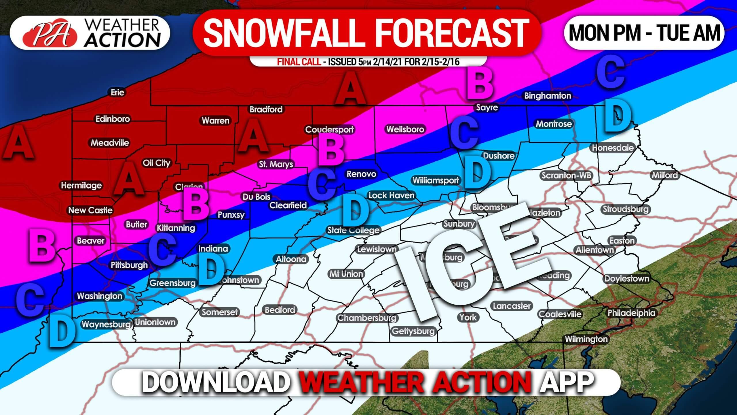
FINAL CALL MONDAY PM – TUESDAY AM SNOWFALL FORECAST
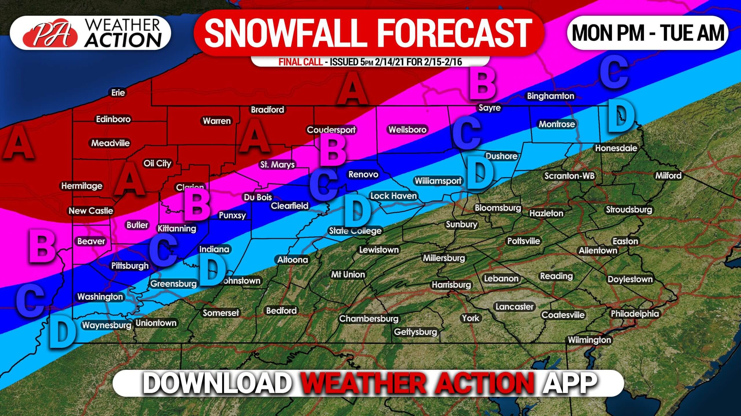
Area A: Snowfall accumulation of 8 – 14″ expected. Snow-packed roads will make travel very difficult Monday afternoon into Tuesday morning.
Area B: Snowfall accumulation of 5 – 8″ expected. After starting as snow, sleet and freezing rain may mix in close to the southern edge of this area, before changing back to snow. Snow-packed roads will make travel very difficult Monday afternoon into Tuesday morning.
Area C: Snowfall accumulation of 3 – 5″ expected. This area will start as snow, then switch over to sleet and freezing rain for much of the storm, possibly ending as another brief period of snow. Travel will be very difficult due to snow and ice-covered roads Monday afternoon into Tuesday morning.
Area D: Snowfall accumulation of 1 – 3″ expected. After briefly starting as snow, sleet and then mostly freezing rain is likely, before possibly ending with a brief period of snow. Travel will be very difficult due to snow and ice-covered roads Monday afternoon into Tuesday morning.
We are also tracking another significant winter storm on Thursday. To receive updates on that, download our app! Get it here >>> Weather Action App
Don’t forget to share this article with family and friends, stay safe!
You must be logged in to post a comment.