Temperatures have dropped significantly over the last 18 hours, after storms in Western PA prompted tornado warnings near Pittsburgh Wednesday evening. We are now switching to winter weather mode, with everything from first flakes of the season to as much as a foot of snow in PA by Friday.
A coastal low pressure system has developed and will be pushing into Southeast New York State by Friday morning, then Eastern PA Friday afternoon. That placement allows cold air to flow in behind the center, which in this case will be southwest of the low pressure. This puts most of Pennsylvania in the crosshairs for accumulating snow.
Heaviest snowfall will be over higher elevations, in mountainous areas above 1500′ elevation. Snow amounts will drop considerably as you go down into the valleys where temperatures are above freezing and downsloping (warmer temperatures, less precipitation downwind of mountains) occurs, namely in places like the Wyoming Valley and much of the Central Susquehanna River Valley.
Final Winter Storm Timing
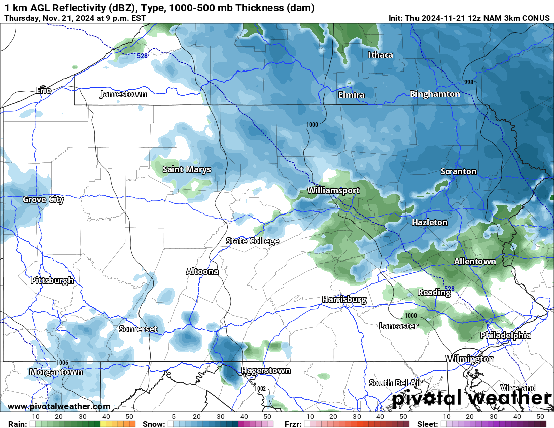
Rain will change to snow over the late evening hours of Thursday across the northeast quarter of the state. The changeover will occur down to around 800′ elevation, with locations lower than that like Wilkes-Barre and Williamsport seeing a mix of rain and snow into the early hours of Friday morning. Below is the Hi-Res NAM model for 9:00 PM Thursday.
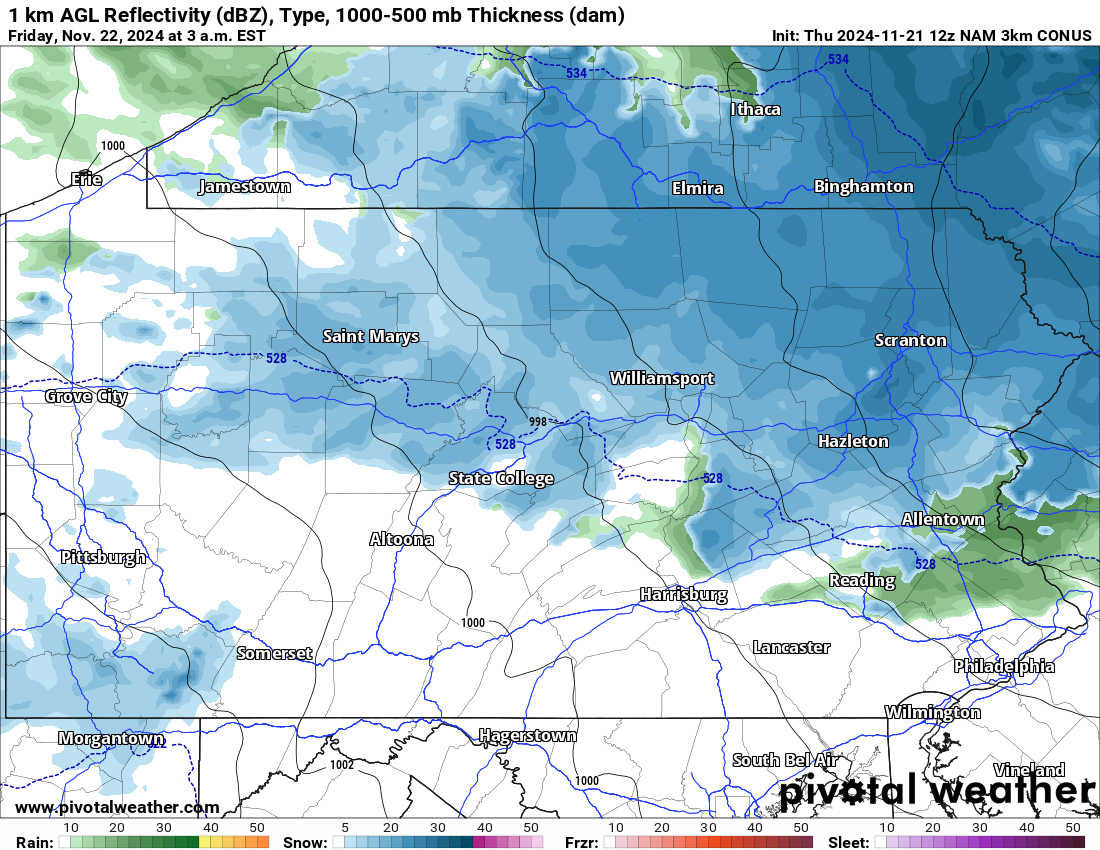
By 3-4 AM Friday, snow will be falling in most places near and north of I-80. Snowfall rates at this time Friday morning will be heaviest in the Northern Poconos, north and east of Scranton. The heavy snow bands will be moving southwest, as upper-level lows travel differently than usual coastal surface lows we see in winter.
Travel will be very difficult by this time in the Northern PA mountains. Speed limits have been reduced to 45mph for this storm on I-81 and I-84 in Northeast Pennsylvania, and we advise avoiding travel in the higher elevations outside of the Wyoming Valley by early Friday morning. Here is the Hi-Res NAM future radar for 3:00 AM Friday.
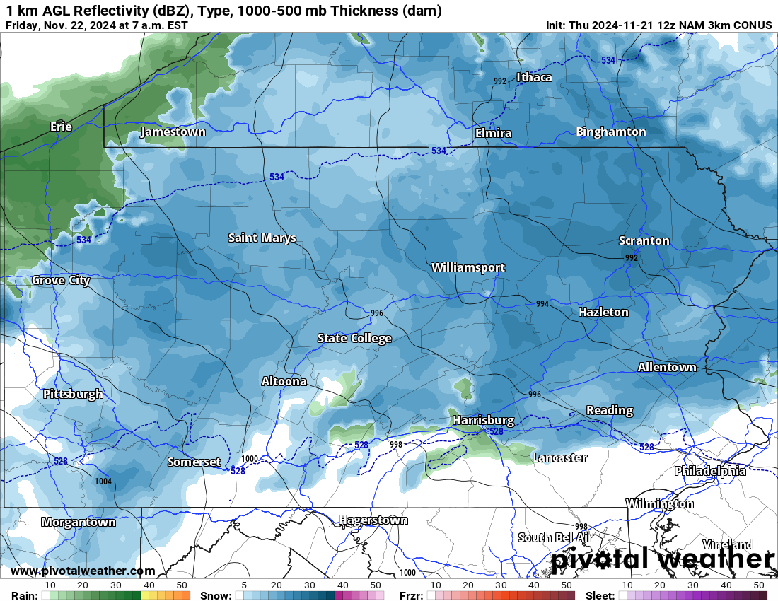
The Friday morning commute is going to be ugly across the Appalachians, with snow overspreading most areas north of I-76 by 6-7 AM Friday. Road impacts from the snow will be minimal below 800′ elevation, which includes most valleys across the state.
Snow will continue pushing south by md-Friday morning as the low pressure nears the state. Southern PA valleys may briefly start as rain before changing to snow as moderate precipitation moves in. Below is Hi-Res NAM future radar for 7:00 AM Friday.
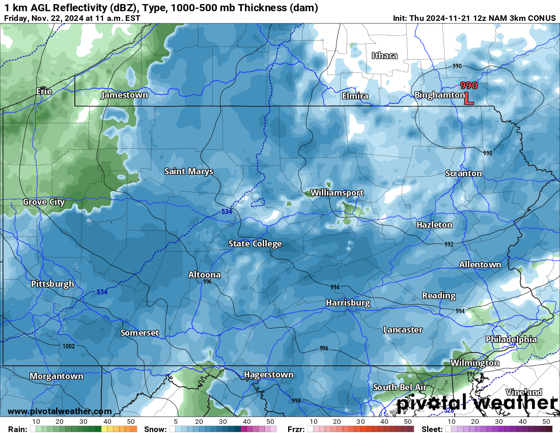
By late Friday morning, as the low pressure pushes closer, snow will overspread the state. Temperatures will be in the mid-30s in most places, with only elevations above 2000′ feet at or below freezing. Snow will likely accumulate on grassy surfaces only in the lowlands. Here is future radar for 11:00 AM Friday.
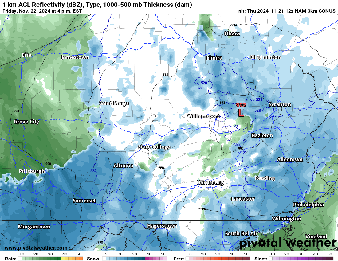
This is a long duration storm as you may be able to tell by now! Snow is anticipated to fall at a heavy rate in the Laurel Highlands by late Friday afternoon into the evening. Meanwhile in the lower Plateau in Western PA, snow is likely to change to rain by this time.
Whereas in Central and Eastern PA, moderate precipitation rates will result in continued snowfall, but areas with lighter precipitation will likely be seeing rain. Below is future radar for 4:00 PM Friday.
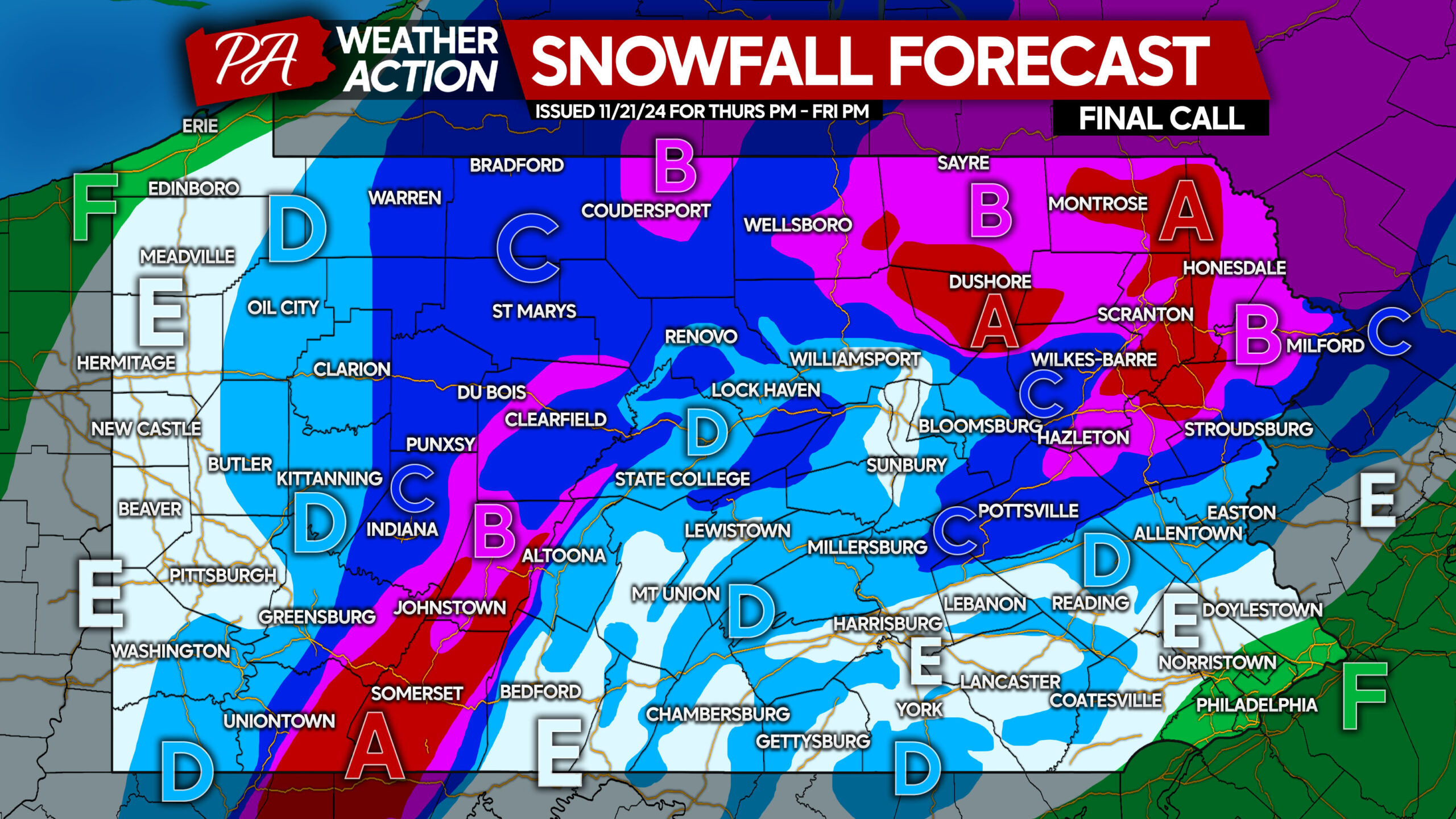
FINAL CALL SNOWFALL FORECAST FOR THURSDAY EVENING – FRIDAY
Area A: Snowfall accumulation of 8 – 12″ anticipated. Roads will be impassible Friday morning, causing work and school closures. Heavy snow and strong winds may cause sporadic power outages due to downed trees on power lines.
Area B: Snowfall accumulation of 4 – 8″ expected. Roads will become snow-covered, likely causing work and school closures. Isolated power outages are possible.
Area C: Snowfall accumulation of 2 – 4″ anticipated. Roadways are likely to become snow-covered or slushy. Work and school delays or cancellations possible.
Area D: Snowfall accumulation of 1 – 2″ expected on grassy surfaces. Roadways will likely remain wet, with slushy conditions possible on untreated surfaces during times of snow.
Area E: Snowfall accumulation of less than 1″ anticipated on grassy surfaces only.
Area F: Rain is expected from start to finish.
Don’t forget to share this forecast with friends and family who will be impacted!


You must be logged in to post a comment.