
The Second Call Snow & Ice Forecast has been posted, as of Friday at 5:00 PM. Please view the article linked below.
Second Call Snow & Ice Forecast for Weekend Wintry Mess Across Pennsylvania
Many have began counting down the days until Spring 2025, but doing that will simply make things worse in the coming weeks as an active winter storm pattern is expected. Here in Pennsylvania, we are caught in between a southeast ridge and cold air to our north and west. That will mean a lot of sloppy messes over the coming weeks.
Some storms may be snowier, while some storms may be mainly rain. We have already seen the differences across PA, especially between Southwest PA and the Appalachians. The coming storm this weekend will be similar to what we just had, though a bit colder.
If you’re looking for all snow, next Tuesday into Wednesday will have higher chances of that. But there’s a lot of details to work out with that storm, and getting this weekend storm out of the way will help.
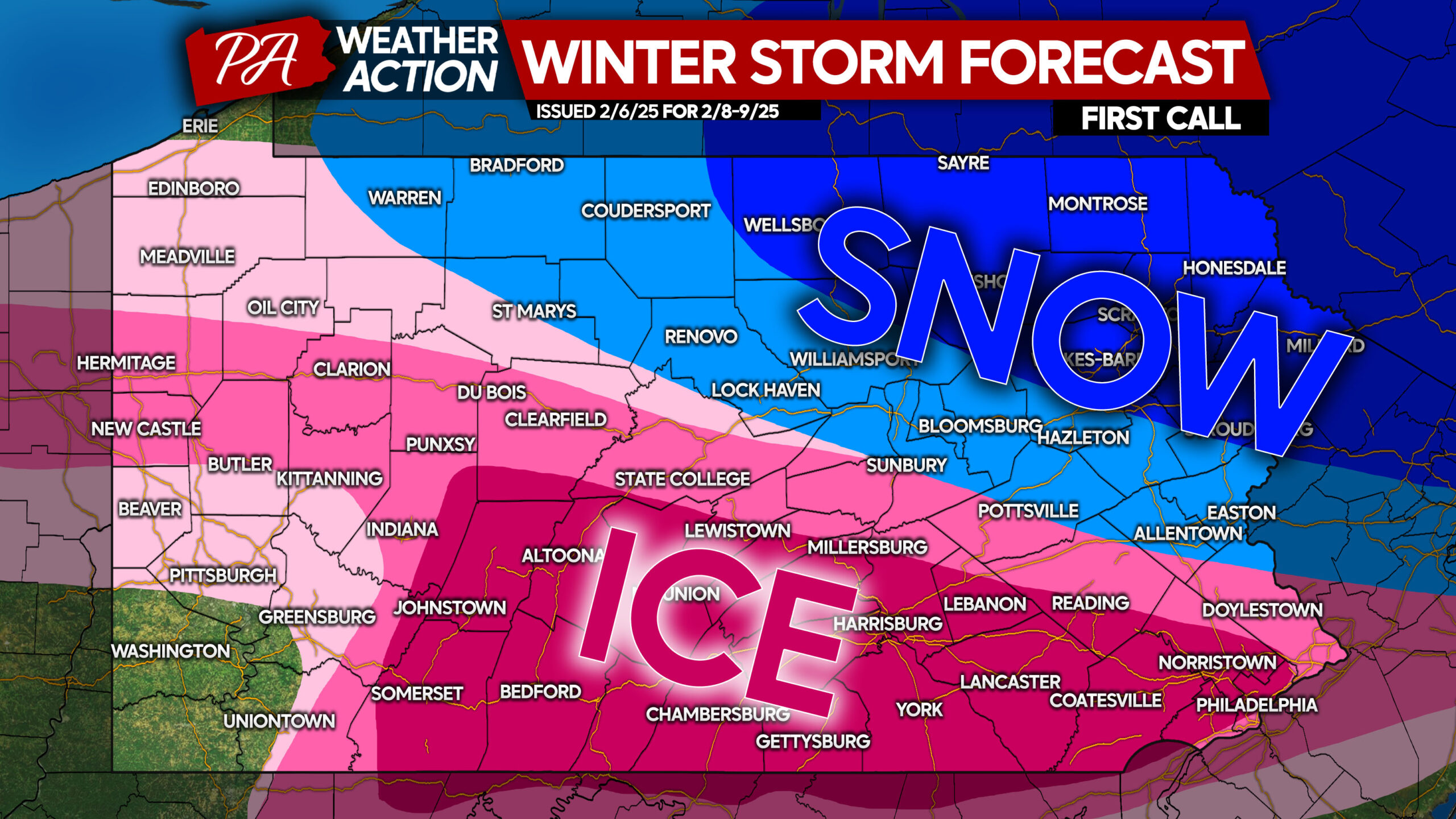
A low pressure will develop in the Midwest on Saturday morning and quickly push into Southwest PA Saturday evening, before transferring to a coastal low pressure east of New Jersey. As a result, precipitation type and amounts with this storm will be latitude-based.
We have seen models trend south over the last two days with this storm, which has brought more snow into the picture north of I-80 and in the Lehigh Valley. This also brought ice farther south, all the way to Philadelphia. We will see where trends go in the coming day.
WINTER STORM TIMING CHARTS
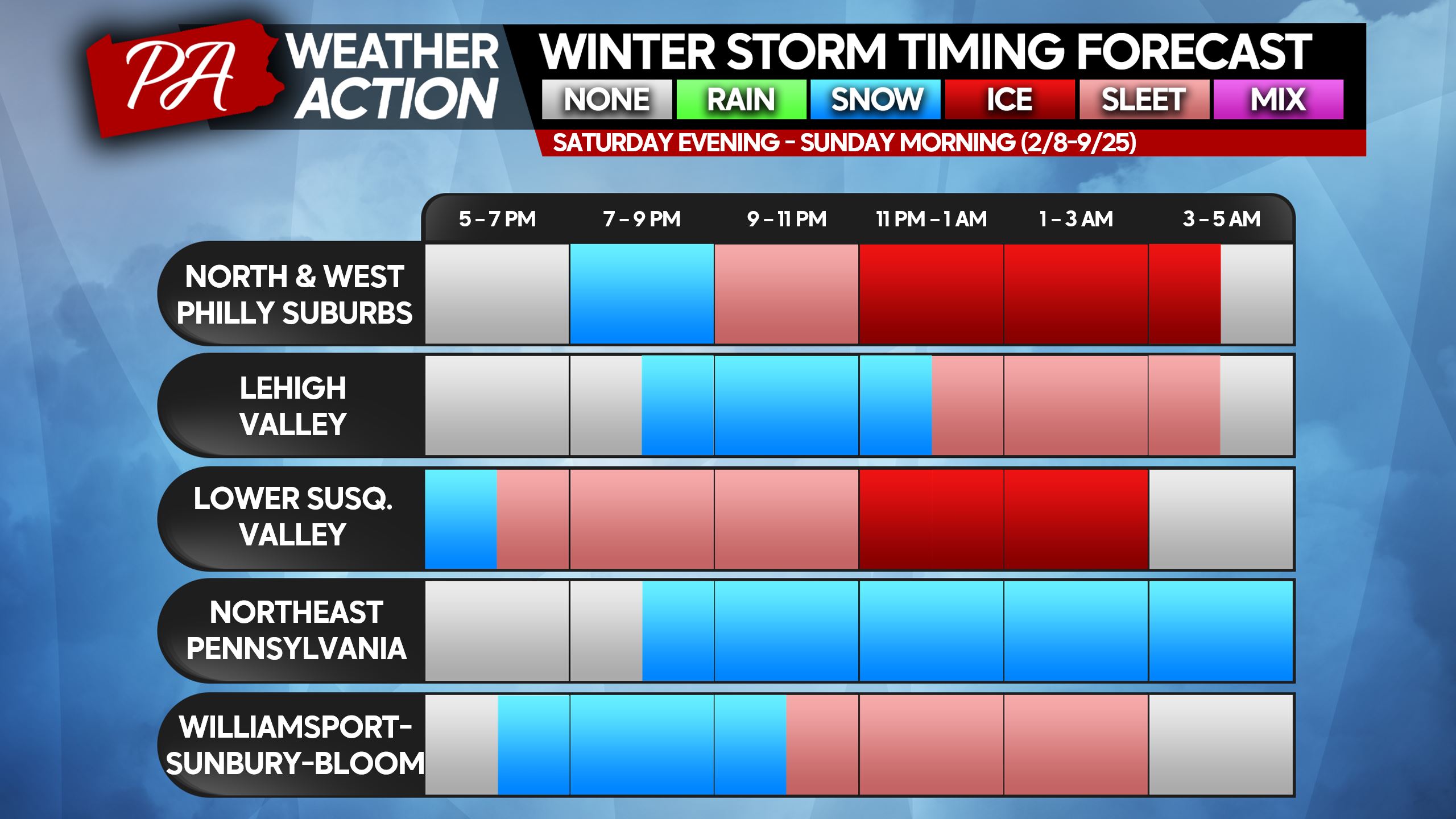
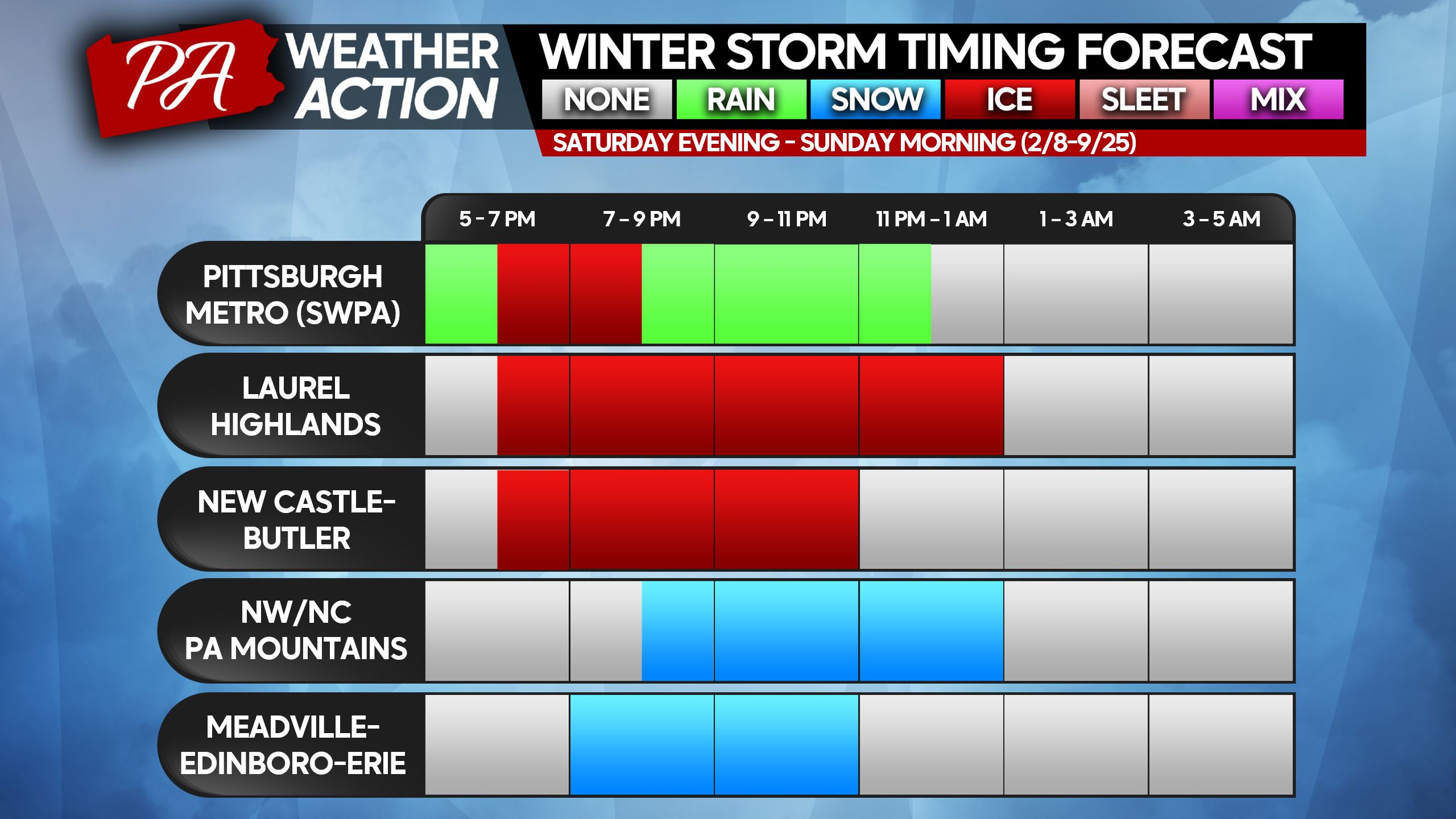
The storm will begin as snow in most places, and that transition to sleet and freezing rain will happen quickly south of I-80. Worst impacts will be felt late Saturday evening into early Sunday morning. We don’t recommend staying out late Saturday evening! By sunset Sunday, this storm will be on its way out.
Please find your nearest town/area on the timing charts below!
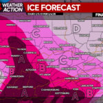
FIRST CALL ICE FORECAST FOR SATURDAY EVENING – SUNDAY MORNING
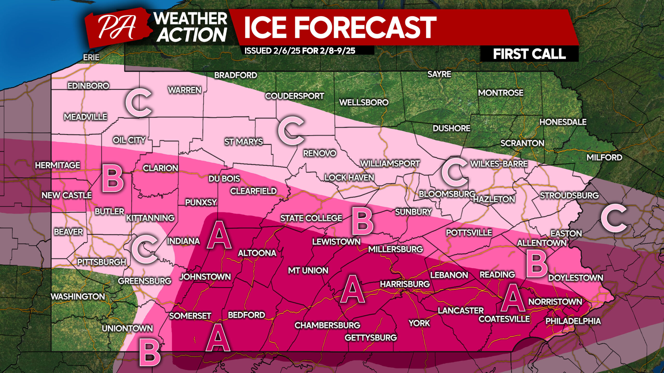
Area A: Ice accumulation between a tenth to a quarter of an inch (0.10 – 0.25″) anticipated. Roads will be icy, and travel is not advised.
Area B: Ice accumulation between a twentieth and a tenth of an inch (0.05 – 0.10″) expected. Slippery roads will cause unsafe travel conditions.
Area C: Ice accumulation of a hundredth to a twentieth of an inch (0.01 – 0.05″) anticipated. Untreated surfaces will be slippery.
FIRST CALL SNOW/SLEET FORECAST FOR SATURDAY EVENING – SUNDAY MORNING
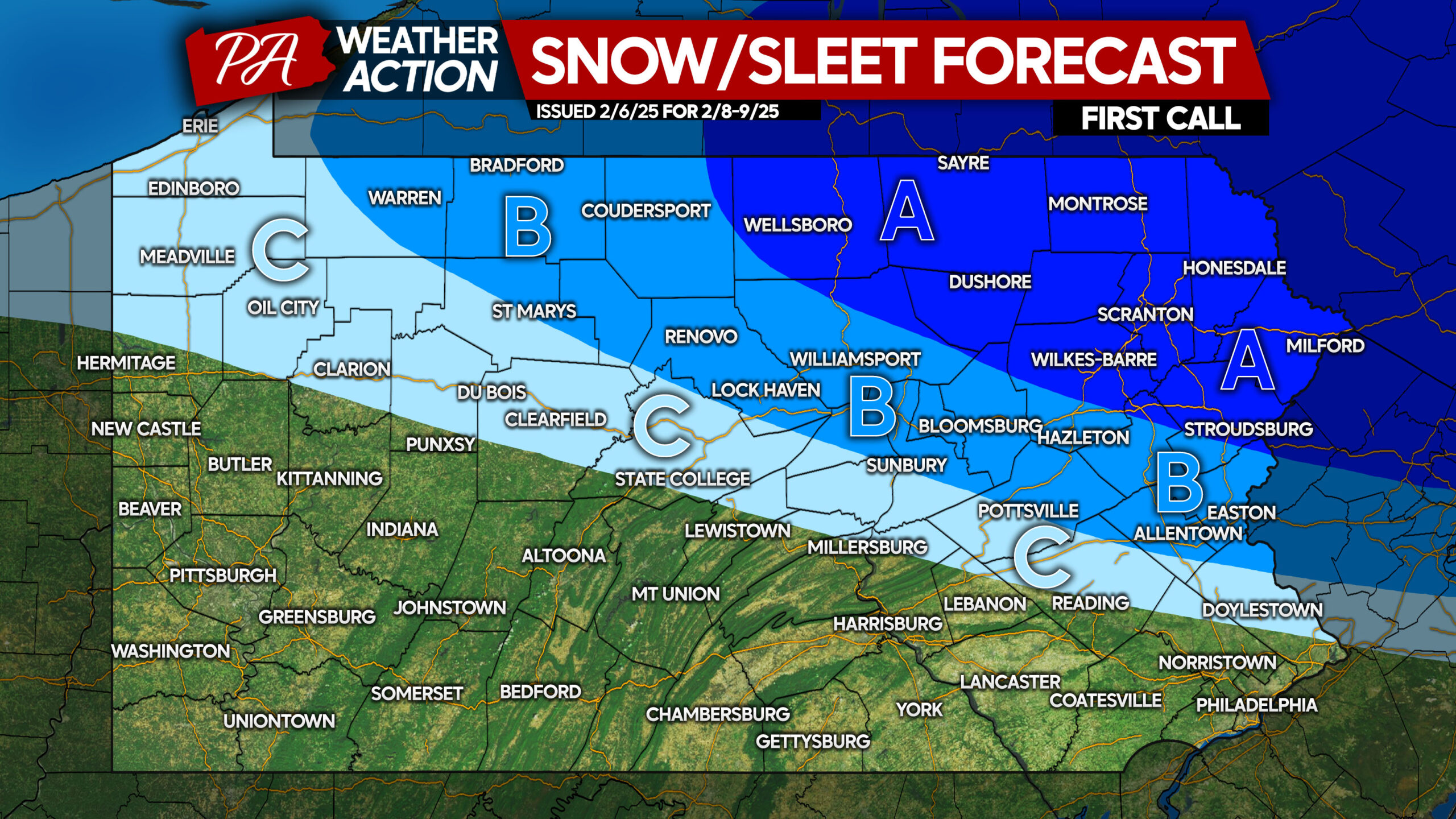
Area A: Snow and sleet accumulation of 4 – 6″ expected. Snow-covered roads will create hazardous travel conditions.
Area B: Snow and sleet accumulation of 2 – 4″ anticipated. Snow-covered roads will create hash travel conditions.
Area C: Snow and sleet accumulation of 1 – 2″ expected. Avoid travel after roads become slushy.
We will have another forecast on Friday at 5:00 PM, stay tuned!
Be sure to share this forecast with friends and family who may have Saturday evening plans.
You must be logged in to post a comment.