
After an overachiever dropped several inches of snow in Pittsburgh suburbs Monday into Tuesday, more snow is on the way with lake effect snow combining with a clipper system. Well over a foot of snow is expected by New Year’s Day in much of Northwest PA, with lighter but considerable amounts elsewhere.
As is the case most clipper systems, the Alleghenies will upslope, absorbing much of the precipitation and leaving east of the mountains dry. Some snow showers may reach the eastern half of PA, with most of the action in Western PA.
Lake effect snow will ramp back up overnight from Meadville to Erie, with scattered snow showers elsewhere. By Wednesday morning (New Year’s Eve), road conditions around Erie will be deteriorated once again. Below is the Hi-Res NAM model for 8:00 AM Wednesday.

Light snow is anticipated Wednesday afternoon in much of Western PA before the clipper pushes in, increasing snowfall rates. By Wednesday evening as many people are heading to celebrations, moderate to locally heavy snow will be falling up and down I-79 in Western PA, along with on I-80 west of Clearfield.

If you’re staying out late for the holiday, be aware of snow squalls in Western and Northern PA early Thursday morning. Especially at a time when fewer road crews will be out, take it slow on snow-covered and slippery roads. Here is future radar for 1:00 AM Thursday.

Snow squalls will calm by daybreak Thursday (New Year’s Day) for the few people who are out and about. Snow showers will continue through the afternoon across Northwest PA before finally clearing out.

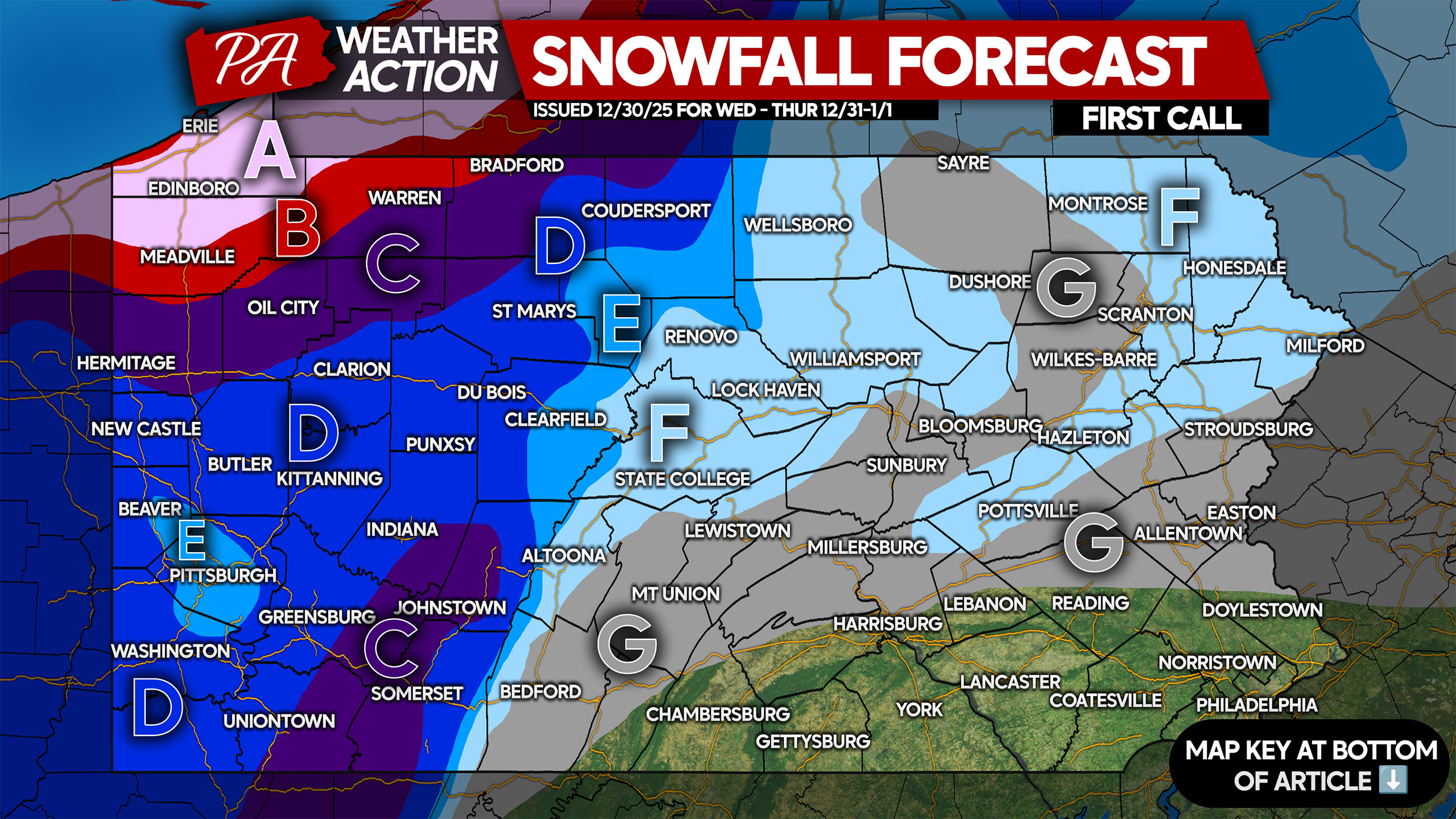
FIRST CALL SNOWFALL FORECAST FOR NEW YEAR’S EVE & DAY

Amounts adjusted 5:50 AM Wednesday to reflect latest forecast.
Area A: Snowfall accumulation of 12-18″ expected. Road conditions will be deeply snow-covered and hazardous for the entirety of Wednesday and Thursday. If traveling long distances, having a snow emergency kit in your car is recommended.
Area B: Snowfall accumulation of 8-12″ expected. Snow-covered roads will make travel treacherous most of Wednesday and Thursday.
Area C: Snowfall accumulation of 5-8″ expected. Roads will be snow-covered from Wednesday evening into Thursday morning.
Area D: Snowfall accumulation of 3-5” expected. Roads will be snow-covered Wednesday evening into early Thursday morning, impacting New Year’s celebrations.
Area E: Snowfall accumulation of 2-3″ expected. Very slippery travel is likely Wednesday evening into Thursday morning.
Area F: Snowfall accumulation of 1-2″ expected. Roads will be slippery especially in more rural areas late Wednesday evening through the predawn hours of Thursday.
Area G: Snowfall accumulation of less than 1″ expected. Scattered slippery conditions are possible during snow showers.
Many people will be out for New Year’s celebrations and not thinking about the weather. Be sure to share this forecast with friends and family!
You must be logged in to post a comment.