
In a winter that has produced very little snow, it shouldn’t be a big surprise some areas may see their biggest snowstorm of the season from a weak low pressure system moving in from the Ohio Valley. Unfortunately for many snow lovers across the state, this storm will be hardest hitting in the Pennsylvania wilds, where there’s likely more deer than people.
Storm Timing
Snow will breakout across Northwest and North Central PA around 6-8pm this evening, probably starting as rain for an hour in the lower valleys. Snow will push east-southeast and enter the Coal Region around 10pm-12am, and the Lehigh Valley by 11pm-1am. Heavy snow will fall at 1-2″ an hour for much of the event, before leaving North Central PA by 12-2am and East Central PA by 2-4am. Here’s the latest 3KM NAM future radar for a better illustration.
Travel Impacts
You will not want to be on the roads during those stated times above. Despite temperatures in the 40s today, temperatures will quickly dive to either side of freezing and snowfall rates will overcome any pretreating or clearing efforts. Stretches of road like I-80 in the central mountains and I-81 near and south of Hazleton will be very rough, and those areas are known for accidents in winter weather.
First Call Snowfall Forecast for Tonight (3/6-3/7/23)
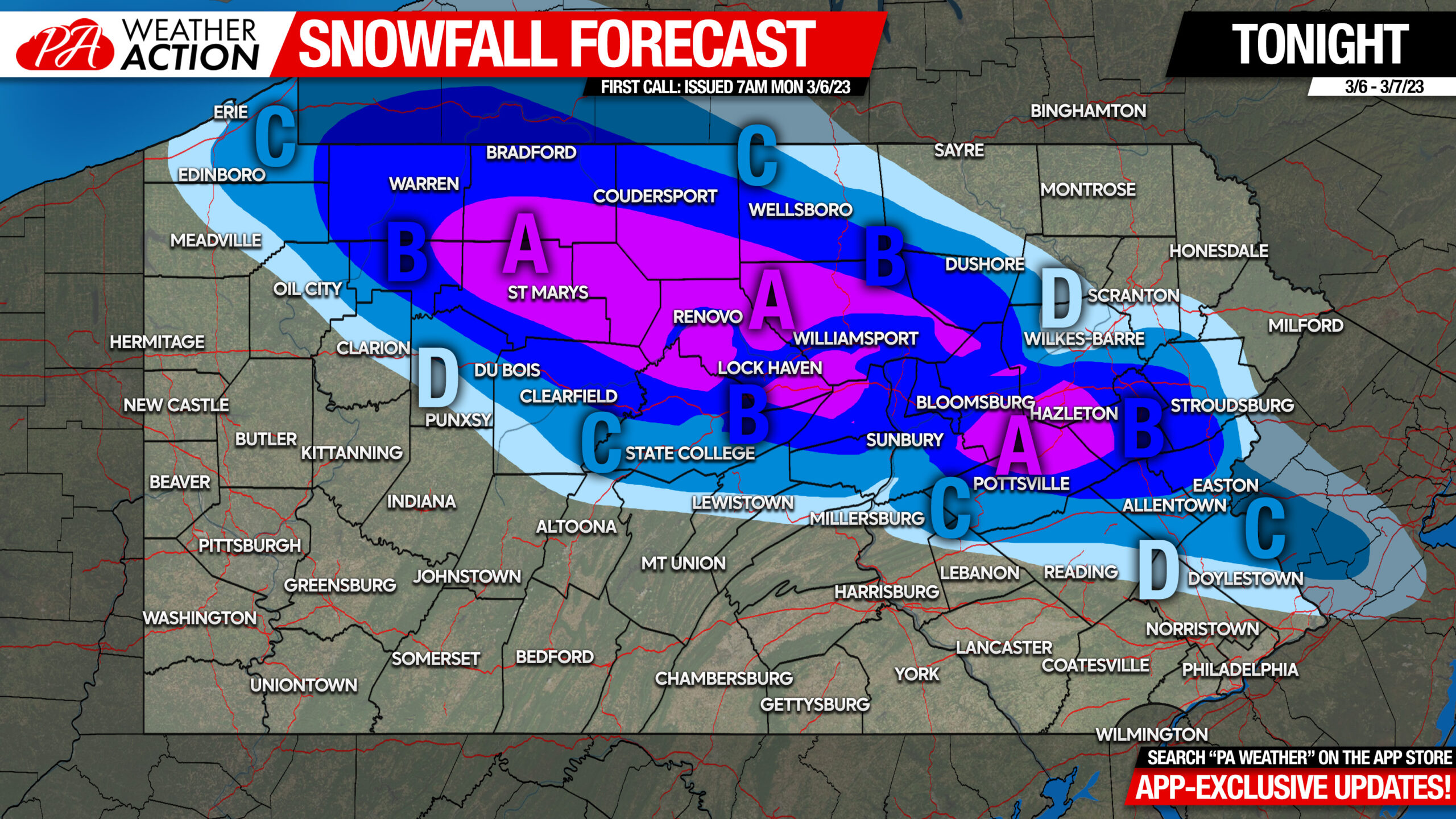
Area A: Snowfall accumulation of 5 – 8″ expected. Travel will be nearly impossible during a period tonight.
Area B: Snowfall accumulation of 3 – 5″ expected. Travel will be very difficult during a period tonight.
Area C: Snowfall accumulation of 2 – 3″ expected. Travel will be very difficult during a period tonight.
Area D: Snowfall accumulation of 1 – 2″ expected.
Stay tuned for an updated forecast later today if needed!
Be sure to share this important forecast with those in the impact areas!
[social_warfare]
Stay on top of everything from winter storms to severe storms multiple days out with latest model maps and trends! Check out the Updates section in our app for this exclusive content!


You must be logged in to post a comment.