
5:20 PM Wednesday Update: FINAL CALL SNOW & ICE FORECAST PSOTED (Click Article Below)
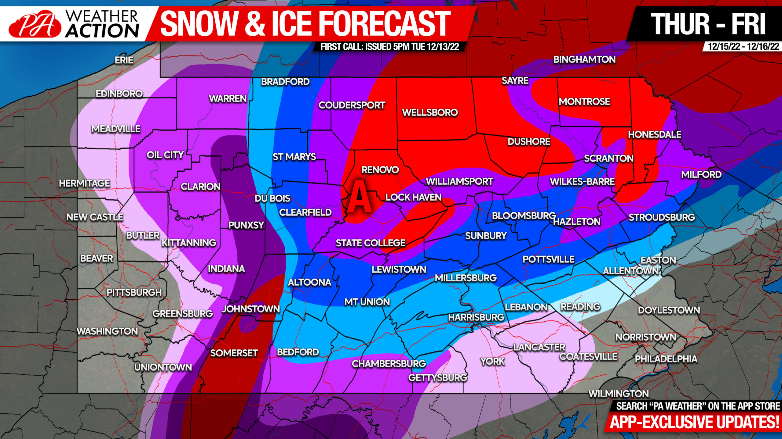
FINAL Call Snow & Ice Accumulation Forecast for Thursday – Friday Significant Winter Storm
Another winter storm in Pennsylvania that will bring very different impacts depending on where in the state you are. Significant snowfall and major ice accumulation likely in some areas, while others see mostly rain. Let’s get right into what you can expect.
Weather Alerts

Timing
Precipitation will move early Thursday morning in Southwest PA to late Thursday morning in Northeast PA. We expect the Alleghenies Mountains to start as freezing rain, while all areas east will begin with sleet. There’s a chance areas east of the Susquehanna River may start as snow. As precipitation becomes heavier, locations generally east of I-99 and north of I-76 are expected to switch to heavy snow.
Heavy snow will then continue in those areas, but rain/snow line will begin working north Thursday afternoon and evening. There may also be a brief period of sleet again before changing to rain. This changeover will come very early on in the storm in Southeast PA, and much later farther north. Below is the latest High Resolution NAM model simulation for most of the storm’s duration.
Road Impacts & Power Outages
Due to the storm beginning in the morning, road impacts will be high. Thursday morning’s commute will vary by location, but the evening will be treacherous nearly everywhere besides southwest and southeast PA. The Friday morning commute should be OK besides in the mountains of Northeast PA.
Widespread power outages are possible in Allegheny Mountains and likely in the Laurel Highlands Thursday afternoon through Friday morning. Scattered power outages are possible just outside of those areas as well, view ice map for reference.
View interactive forecast maps that are centered on your town here: https://paweatheraction.com/interactive-forecast-map/
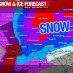
First Call Ice Forecast for Thursday
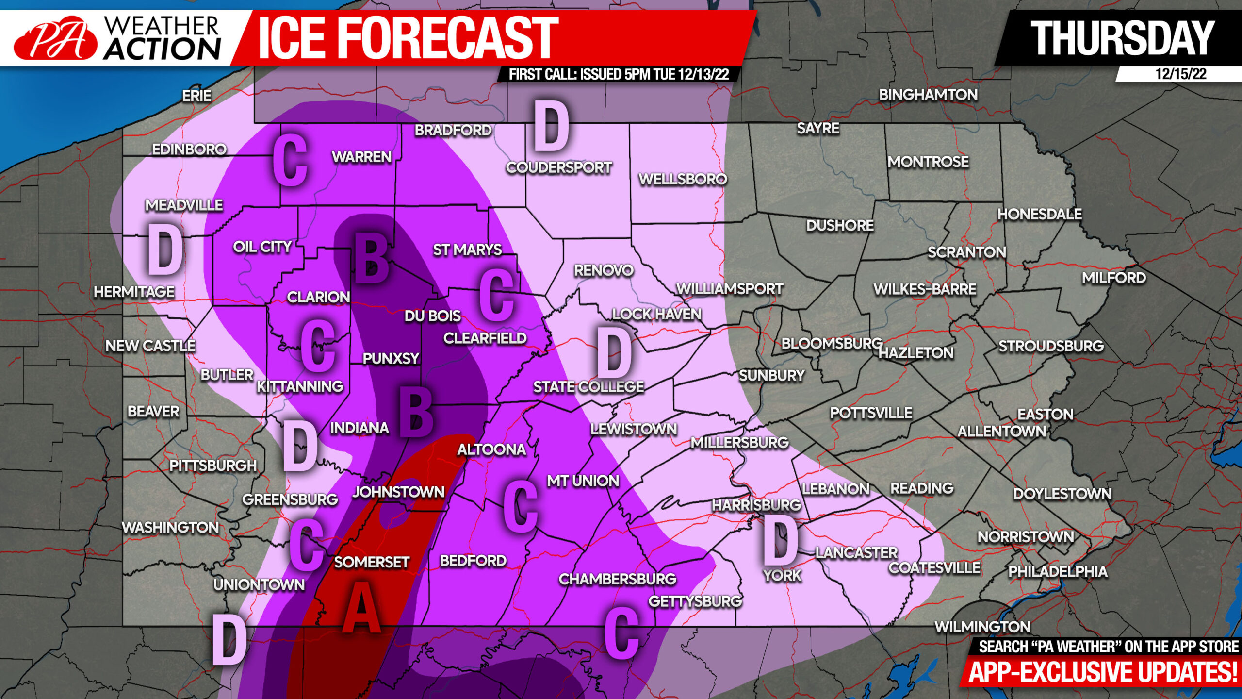
Area A: Ice accumulation of .50 – .75″ expected. Widespread power outages are expected Thursday, lasting into Friday.
Area B: Ice accumulation of .25 – .50″ expected. Scattered power outages are expected Thursday, lasting into Friday.
Area C: Ice accumulation of .10 – .25″ expected. Scattered power outages possible Thursday.
Area D: Ice accumulation of .01 – .10″ expected. Isolated power outages possible Thursday.
First Call Snowfall Forecast for Thursday – Friday
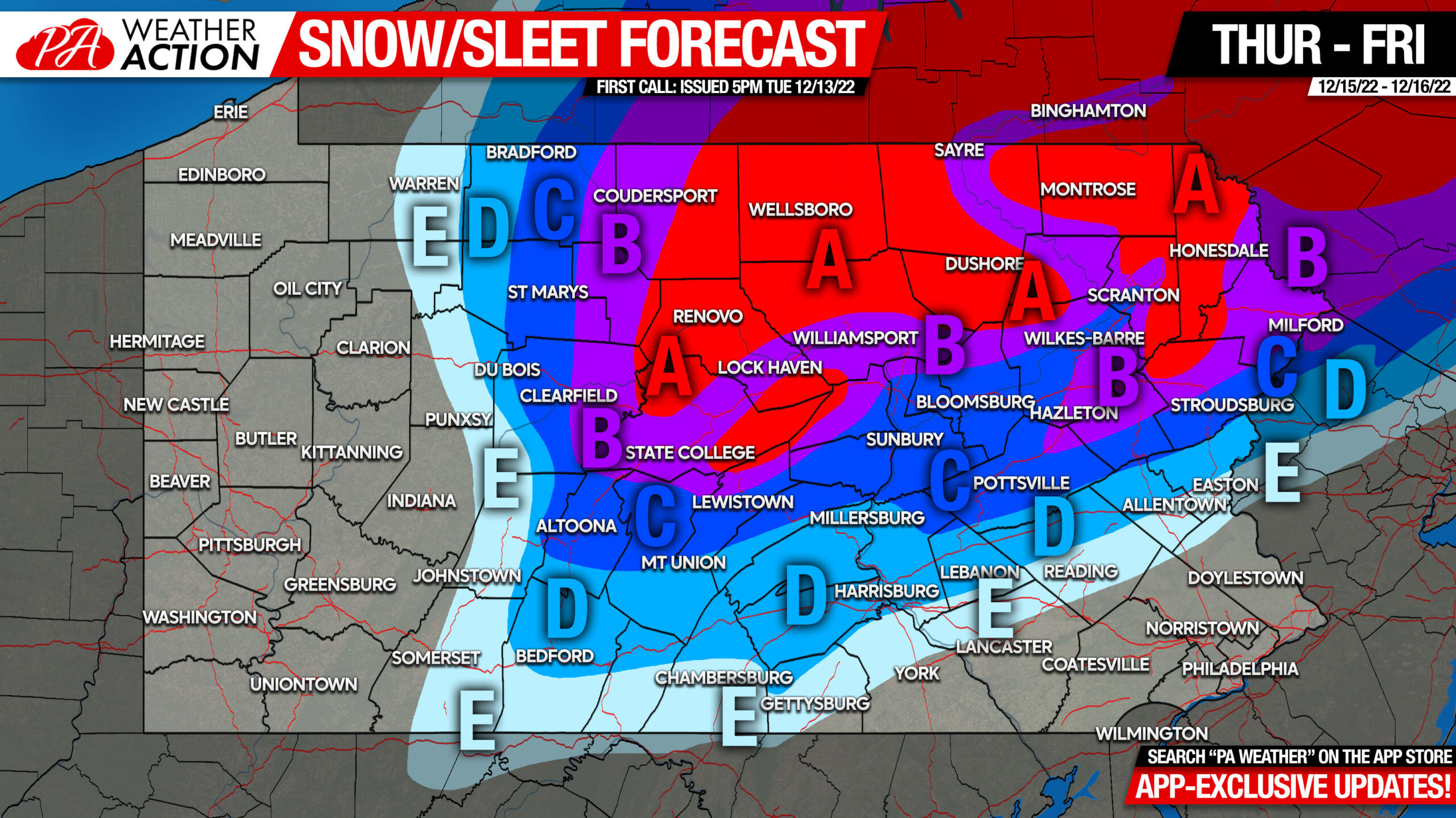
Area A: Snow and sleet accumulation of 6 – 9″ expected. Snow-covered roads likely late Thursday morning through Friday morning.
Area B: Snow and sleet accumulation of 4 – 6″ expected. Snow-covered roads likely late Thursday morning through Friday morning.
Area C: Snow and sleet accumulation of 2 – 4″ expected. Slushy roads are likely mid-late Thursday morning through late Thursday evening.
Area D: Snow and sleet accumulation of 1 – 2″ expected. Slushy roads possible mid-late Thursday morning through mid Thursday evening.
Area E: Snow and sleet accumulation of less than 1″ expected.
Be sure to share this forecast with family and friends in areas where considerable impacts are forecast.
[social_warfare]
If you would like to stay ahead of the latest short range model trends leading up to this storm and those to come this season, checkout the Updates section of our app! Either way, I highly recommend you try out our app. It has these handwritten updates as well as forecast and radar straight from your local NWS office. Tap the banner below!

You must be logged in to post a comment.