
Our forecast has been updated. View the latest updated forecast here: First Call Snowfall Forecast & Timing
This is probably the last thing you expected to be reading today, but we have to remember that this is March. Several of the past March’s have featured surprise winter storms, after days when high temperatures soared into the 70s, like tomorrow (Friday). To preface, this will be nothing that will require you to stock up on any more toilet paper than you already have, as anything that falls will immediately begin to melt on Tuesday. We are looking at the epitome of a “thread the needle” type event.
After showers and thunderstorms move through the state tomorrow, a cold front will follow behind. High temperatures Saturday will be about 20 degrees colder than Friday, and most of us will fall into the 20s Sunday morning. The cold air is currently modeled to be just deep enough to result in a snowy side to the coastal storm will develop off the Del-Mar-Va Monday morning. The greatest threat for accumulating snow looks to be in the Appalachian Mountains (including the Poconos). However, there is still a chance that the system could be weaker and not draw in as much cold air.
STORM TIMING:
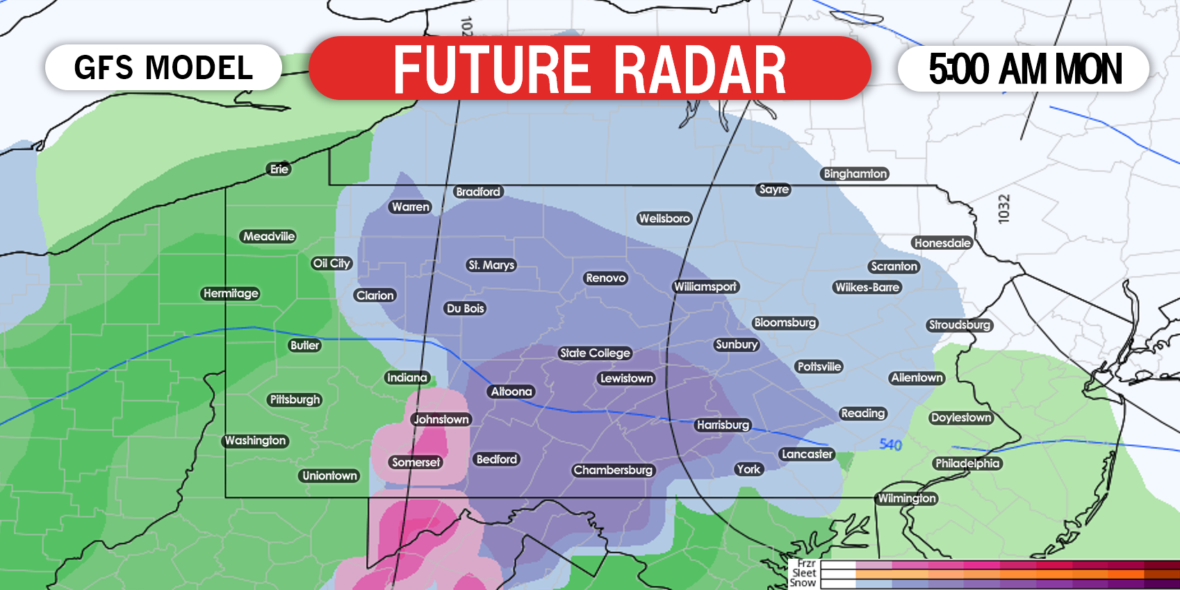
Precipitation is currently expected to move into southern Pennsylvania a few hours before sunrise Monday morning. This will help set a base before the sun angle gets stronger, making it easier for the snow to accumulate later in the day, given that rates will be moderate to heavy. However, much of western PA and southeast PA will likely start as rain. Below is the GFS model future radar for 5:00 AM Monday. All other major models are similar.
As the coastal low begins to strengthen, some areas that don’t begin as snow could actually change over to snow just after sunset Monday as dynamic cooling takes place (heavier precipitation rates can cool temperatures at all layers). By 11 AM Monday, much of central and eastern PA could be seeing moderate snowfall. Confidence in that statement increases the closer you are to i80, as the rain/snow line is modeled to be near i78. Here is future radar for 11:00 AM Monday.

The rain/snow line is likely to slowly push north in central and eastern PA Monday afternoon. The European and Canadian models have a slightly stronger coastal system, and keep the snow going until mid-evening Monday in much of northeast PA. The GFS ends precipitation a little sooner. Below is the GFS future radar for 5:00 PM Monday.

Since we are still about 3.5 days away from this potential storm, our snowfall forecast will not be too aggressive. It will all depend on how strong the coastal storm is. Definitely check back for updates to this forecast in the coming days.
FIRST LOOK AT MONDAY’S SNOWFALL POTENTIAL
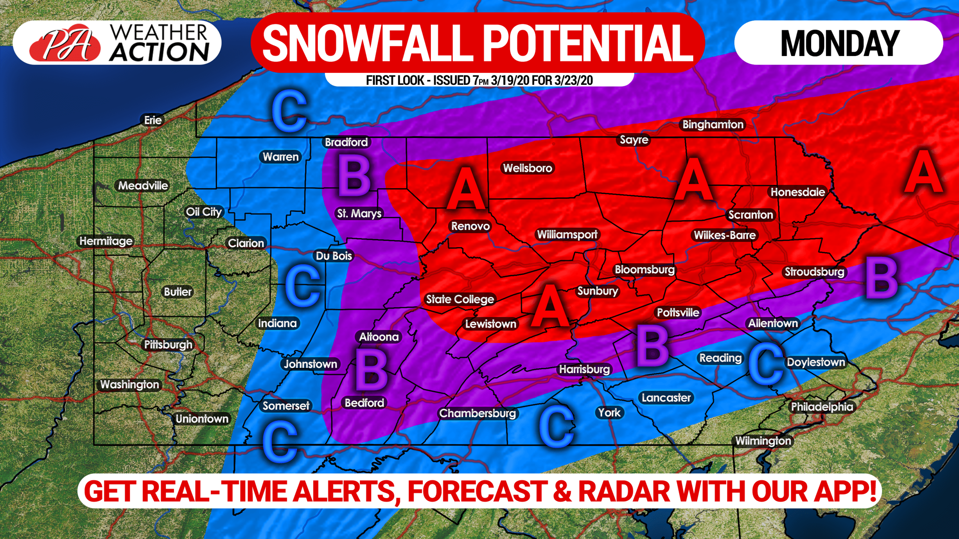
Area A: There is above a 50% chance this region will see 5″ or more of snowfall, given that it will likely stay snow the entire storm. Also, much of this area is highly elevated, which helps as March storms can be very elevation-dependent.
Area B: There is above a 50% chance this region will see 3″ or more of snowfall. Temperatures will be in the mid 30s for much of the storm, and the rain/snow line will be very close to the southern edge of this area. Currently we expect these locations to see mainly snow, but that may change.
Area C: There is above a 50% chance this region will see 1″ or more of snowfall. The rain/snow line will likely be within this area, and temperatures will be in the mid to upper 30s during the storm.
The potential impacts of this system all depend on the intensity of the coastal low pressure. Stay tuned for updated forecasts in the next few days.
A great way to do so is with our app. We send push notifications immediately when a new forecast is issued. Download it on iOS & Android here: Weather Action App Link
Don’t forget to share this forecast with your friends and family! Stay safe and stay tuned!
You must be logged in to post a comment.